
Petersburg, Virginia — The American South (Mid-Atlantic)
Pocahontas
The Revolutionary War
Photographed by Bernard Fisher, January 21, 2010
1. Pocahontas Marker
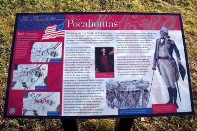
On 25 April 1781, this part of the community of Pocahontas served as the rear guard staging area for American Major General Frederick von Steuben’s Virginia militia in their defense of Petersburg against the invading British army under Major General William Phillips.
During the evening and night before the battle, troops of Brigadier General Peter Muhlenberg’s Corps had encamped in Pocahontas and on the Heights (now Colonial Heights) above the community to protect the army from any possible British surprise attack. This encampment had also served to receive and assemble additional gathering militia being called up for the emergency. On the morning of the battle, von Steuben moved his army to positions on the eastern edges of Petersburg and Blandford to prepare for battle. He deployed elements of the Chesterfield County militia, under Colonel Robert Goode, and two companies of Lieutenant Colonel Robert Caul’s Virginia cavalry, including one which was commanded by Captain Robert Bolling IV of Petersburg, along this north side of the Appomattox River all the way downstream to Bermuda
this page online
The Pocahontas community was important for its many warehouses and docks, which supported Petersburg’s large harbor and tobacco economy and maintained military stores for the American Continental Army. The Pocahontas Bridge, a narrow wooden structure, was a significant avenue of movement for troops and supplies of the Continental Army during the war.
(sidebar)
Battle Sequence
These
Photographed by Bernard Fisher, January 21, 2010
2. Pocahontas Marker
Topics. This historical marker is listed in these topic lists: War, US Revolutionary • Waterways & Vessels. A significant historical date for this entry is April 25, 1781.
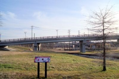
Location. Marker has been reported missing. It was located near 37° 14.193′ N, 77° 24.136′ W. Marker was in Petersburg, Virginia. It was at the intersection of Pocahontas Street and Bridge Street, on the right when traveling north on Pocahontas Street. Touch for map. Marker was in this post office area: Petersburg VA 23803, United States of America. Touch for directions.

Regionally, this marker was in Central Virginia. It was also in the American South and specifically in the Upper South. Globally, it was in North America, the Western Hemisphere, the Western World, and the Anglosphere. Historically, it found itself in what was once the territory of the Mississippian Culture, one of the original Thirteen Colonies, one of the Confederate States of America, and the Antebellum South.
Other nearby markers. At least 8 other markers are within walking distance of this location: Charles Stewart (within shouting distance of this marker); Pocahontas Island (within shouting distance of this marker); South Side Station (approx. 0.2 miles away); a different marker also named South Side Station (approx. 0.2 miles away); The McIlwaine House (approx. ¼ mile away); Bollingbrook Hotel (approx. ¼ mile away); Farmers Market (approx. ¼ mile away); 1864-1865: The Bombardment of Petersburg (approx. ¼ mile away). Touch for a list and map of all markers in Petersburg.
Other markers no longer nearby. The Battle at the Bridge (was about 400 feet away, measured in a direct line but has been confirmed missing); a different marker also named South Side Station (was approx. 0.2 miles away but has been replaced with another marker now near it).
More about this marker. On the left are three maps entitled, “First phase of the Battle of Petersburg”, “Second phase of the Battle of Petersburg”, and “Final phase of the Battle of Petersburg”,
On the center is an image of “British Commander Major General William Phillips”. Courtesy of the National Army Museum, London.
On the right is an image of “Major General Frederick Von Steuben from an engraving by Frederick Girsch, courtesy of the Library of Congress.”
On the lower right is an image of “Virginia Militia In Action during the Battle at the Bridge.” Courtesy of the Artist, Robert P. Davis.
Also see . . . American Revolution Round Table - Richmond. The ARRT-R of Richmond is devoted to the study of all aspects of the Revolutionary period (ca. 1763-89). (Submitted on January 24, 2010.)
Credits. This page was last revised on February 8, 2025. It was originally submitted on January 24, 2010, by Bernard Fisher of Richmond, Virginia. This page has been viewed 1,514 times since then and 25 times this year. Last updated on February 8, 2025, by Evan Dwyer of Richmond, Virginia. Photos: 1, 2. submitted on January 24, 2010, by Bernard Fisher of Richmond, Virginia. • J. Makali Bruton was the editor who published this page.
