Long Bridge Park in Arlington in Arlington County, Virginia — The American South (Mid-Atlantic)
Bridging the Past
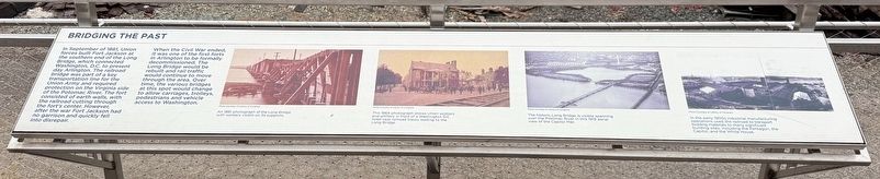
In September of 1861, Union forces built Fort Jackson at the southern end of the Long Bridge, which connected Washington, D.C. to present day Arlington. The railroad bridge was part of a key transportation line for the Union Army and required protection on the Virginia side of the Potomac River. The fort consisted of earth walls, with the railroad cutting through the fort's center. However, after the war Fort Jackson had no garrison and quickly fell into disrepair.
When the Civil War ended,it was one of the first forts in Arlington to be formally decommissioned. The Long Bridge would be rebuilt and rail traffic would continue to move through the area. Over time, the various bridges at this spot would change to allow carriages, Trolleys, pedestrians and vehicle access to Washington.
[Captions:]
An 1861 photograph of the Long Bridge with workers visible on its supports.
This 1864 photograph shows Union soldiers and artillery in front of a Washington D.C. hotel near railroad tracks leading to the Long Bridge.
The historic Long Bridge is visible spanning over the Potomac River in this 1919 aerial view of the Capitol Mall.
In the early 1900s industrial manufacturing operations used the railroad to transport building materials to many significant building sites, including the Pentagon, the Capitol, and the White House.
Topics and series.
this page online
Location. 38° 52.218′ N, 77° 2.555′ W. Marker is in Arlington, Virginia, in Arlington County. It is in Long Bridge Park. It can be reached from the intersection of Long Bridge Drive and Boundary Drive, on the left when traveling south. Touch for map. Marker is at or near this postal address: 333 Long Bridge Drive, Arlington VA 22202, United States of America. Touch for directions.

Regionally, this marker is in the Washington Metropolitan Area and in Northern Virginia. It is also in the American South, specifically in the Upper South, in the Mid-Atlantic, and on the Eastern Seaboard. Globally, it is in the North Atlantic Region, North America, the Western Hemisphere, the Western World, and the Anglosphere. Historically, it finds itself in what was once the territory of the Mississippian Culture, one of the original Thirteen Colonies, one of the Confederate
Other nearby markers. At least 8 other markers are within walking distance of this marker: Fort Runyon (about 700 feet away, measured in a direct line); A Historic Junction (approx. 0.2 miles away); Looking Beyond the Park (approx. 0.2 miles away); Long Bridge Park: A Legacy of Recreation (approx. 0.2 miles away); From Brownfield to Playing Fields (approx. 0.3 miles away); Arlington's Natural Side (approx. 0.3 miles away); A Roadside Respite (approx. 0.4 miles away); Ronald Reagan Washington National Airport & George Washington Memorial Parkway (approx. half a mile away). Touch for a list and map of all markers in Arlington.
Other markers no longer nearby. Long Bridge Park: A Community Space (was approx. 0.2 miles away but has been replaced with another marker now near it); a different marker also named From Brownfield to Playing Fields (was approx. 0.3 miles away but has been replaced with another marker now near it).
Credits. This page was last revised on February 9, 2025. It was originally submitted on February 9, 2025, by Devry Becker Jones of Washington, District of Columbia. This page has been viewed 130 times since then and 21 times this year. Photos: 1, 2. submitted on February 9, 2025, by Devry Becker Jones of Washington, District of Columbia.
