North Shore in Duluth in Saint Louis County, Minnesota — The American Midwest (Upper Plains)
Prospectors & Settlers

Photographed by Cosmos Mariner, June 24, 2024
1. Prospectors & Settlers Marker
Before 1840, rumors of copper deposits along the North Shore's hills and streams had captured the interest of mineral prospectors. With the 1854 Treaty of La Pointe, the Ojibwe people reluctantly ceded their territories to the United States. Land between Fond du Lac and the Canadian border then opened to European settlement. Prospectors poured into the region to stake their claims.
In 1855, Clifton was the first town to be platted. At the mouth of the Talmadge River (just a stone's throw from present-day McQuade Harbor), Clifton was poised for the anticipated copper boom. But sufficient quantities of minerals were never found and Clifton became a ghost town existing only on paper. Other nearby towns, including Montezuma, Buchanan, and Agate Bay met the same fate.
[photo and illustration captions]
• North Shore Fishing, circa 1873
By 1870, a railway linking Duluth to St. Paul markets created a boom for North Shore commercial fishing. Note the plentiful lake trout and whitefish and the birchbark canoe — many Ojibwe people have fished commercially on Lake Superior.• Clifton Town Site Plat (Detail), 1855
Two proposed piers extended• Traces of 19th Century Copper Mininghundreds of feet into Lake Superior, forming a breakwater. Although this town was never built, there has been settlement and activity here ever since.
Click or scan to see
this page online
Topics. This historical marker is listed in these topic lists: Indigenous Peoples and Communities • Industry & Commerce • Settlements & Settlers. A significant historical year for this entry is 1855.
Location. 46° 52.876′ N, 91° 55.128′ W. Marker is in Duluth, Minnesota, in Saint Louis County. It is in North Shore. It can be reached from the intersection of Congdon Boulevard (North Shore Drive) (State Highway 61) and McQuade Road, on the left when traveling north. The marker is located in the McQuade Small Craft Harbor interpretive kiosk, overlooking Lake Superior. Touch for map. Marker is at or near this postal address: 5105 Congdon Boulevard, Duluth MN 55804, United States of America. Touch for directions.

Regionally, this marker is in the Arrowhead Region and in the Iron Range. It is also in the American Midwest and in the Corn Belt. Globally, it is in North America, in the Great North Woods, on the Great Lakes, in the Western

Minnesota Historical Society
2. Marker detail: Loading a Log Rail Car Near Duluth, 1885
Timber interests operated extensively in the area from the 1880s to 1910. The Scott & Holston Company operated a log landing at Clifton and there were shingle and broomstick mills on the Talmadge River.
Other nearby markers. At least 8 other markers are within 7 miles of this marker, measured as the crow flies: Commercial Fishing (here, next to this marker); Highway 61: Road to Tourism (here, next to this marker); Superior: One Great Lake (here, next to this marker); Boatwatching (here, next to this marker); Safe Haven from Wild Winds and Waves (here, next to this marker); Clifton–French River (approx. 1.6 miles away); The Skyline Parkway (approx. 5.1 miles away); Buchanan (approx. 6½ miles away). Touch for a list and map of all markers in Duluth.
Related markers. Click here for a list of markers that are related to this marker. Clifton
Also see . . .
1. Samuel Caldwell McQuade (Veterans Memorial Hall).
Excerpt: Samuel Caldwell McQuade was born in July 4th, 1829, to Captain James Maynard & Elizabeth McQuade in Kittanning, Pennsylvania.(Submitted on February 23, 2025, by Cosmos Mariner of Cape Canaveral, Florida.)
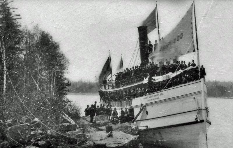
He moved west to Ontonagon, Michigan in searchof copper deposits. There he married Abigail Eliza [Hayward] in 1856, and they started a family. They moved to the Duluth area and established a trading post at Endion; he was one of the first three white settlers in the area.George A. Newton/Northeast Minnesota Historical Center, Duluth3. Marker detail: The Steamboat Ossifrage, Knife River, 1888Before roads were built in the 1920s, steamers, fishing boats, and canoes carried passengers, supplies, fish shipments, and mail to the communities of the North Shore.
Samuel was one of 18 locals of the St. Louis County area that served with the Union during the Civil War. He mustered in as a Private (PVT) with Company F & S of the 27th Michigan Volunteer Infantry Regiment at Ypsilanti, Michigan. He rose to the rank of 2nd Lieutenant (2LT) serving as a musician. Several prominent battles they participated in were Vicksburg, Wilderness, Spotsylvania, Petersburg and the Appomattox Campaign.
After the war he returned home to his family in Duluth. He was elected Alderman and afterwards served a term as county commissioner. In 1878 he was elected sheriff and later appointed Chief of Police in 1890.
2. 1854 Treaty of La Pointe (Wikipedia).
Excerpt: The treaty ceded all of the Lake Superior Ojibwe lands to the United States in the Arrowhead Region of Northeastern Minnesota, in exchange for(Submitted on February 23, 2025, by Cosmos Mariner of Cape Canaveral, Florida.)reservations for the Lake Superior Ojibwe in Wisconsin, Michigan, and Minnesota. The signatory tribes retain hunting, fishing and gathering right within this region. The portions left unceded were given claims to the Mississippi Ojibwe. 4. Marker detail: Samuel McQuadeIn 1854, Samuel McQuade traveled from Michigan to Duluth to search for copper. "I came on snowshoes," he said. He built this area's first homestead in the 1860s and served as the first County Sheriff. Nearby McQuade Road has been a local thoroughfare since 1914.

Photographed by Cosmos Mariner, June 24, 2024
5. Prospectors & Settlers Marker
This is the leftmost of three panels on the north side of the McQuade Small Craft Harbor interpretive kiosk.
Photographed by Cosmos Mariner, June 24, 2024
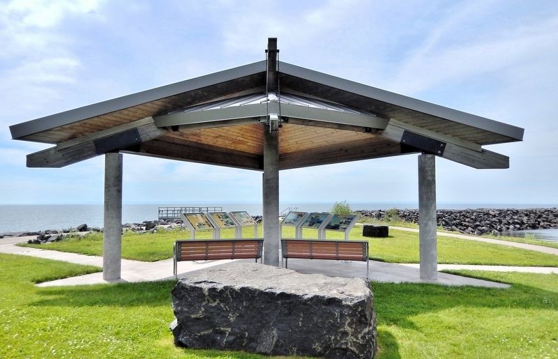
6. McQuade Small Craft Harbor Interpretive Kiosk
The interpretive kiosk is on the south side of North Shore Drive, overlooking Lake Superior. Access to the kiosk is from the parking lot on the north side of North Shore Drive. There is a pedestrian access tunnel under the highway. This is the leftmost of six interpretive panels in the kiosk.
Credits. This page was last revised on February 23, 2025. It was originally submitted on February 22, 2025, by Cosmos Mariner of Cape Canaveral, Florida. This page has been viewed 275 times since then and 33 times this year. Photos: 1, 2. submitted on February 22, 2025, by Cosmos Mariner of Cape Canaveral, Florida. 3. submitted on February 23, 2025, by Cosmos Mariner of Cape Canaveral, Florida. 4, 5, 6. submitted on February 22, 2025, by Cosmos Mariner of Cape Canaveral, Florida.
