Near Blacksburg in Cherokee County, South Carolina — The American South (South Atlantic)
James Williams at Kings Mountain
⎯⎯⎯
The Battle of Kings Mountain
Photographed by Dave W, July 30, 2022
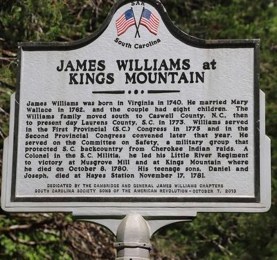
1. James Williams at Kings Mountain Marker
James Williams at Kings Mountain
James Williams was born in Virginia in 1740. He married Mary Wallace in 1762, and the couple had eight children. The Williams family moved south to Caswell County, N.C., then to present day Laurens County, S.C. in 1773. Williams served in the First Provincial (S.C.) Congress in 1775 and in the Second Provincial Congress convened later that year. He served on the Committee on Safety, a military group that protected S. C. backcountry from Cherokee Indian raids. A Colonel in the S. C. Militia, he led his Little River Regiment to victory at Musgrove Mill and at Kings Mountain where he died on October 8, 1780. His teenage sons, Daniel and Joseph, died at Hayes Station November 17, 1781.
The Battle of Kings Mountain
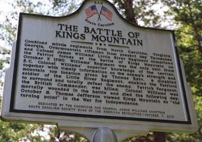
Combined militia regiments from North Carolina, Virginia. Georgia, Overmountain riflemen from present day Tennessee and Colonel James Williams' Little River Regiment comprised the Patriot forces at the Battle of Kings Mountain on October 7, 1780. Williams' Regiment was the only unit from S.C. Colonel Williams' superior knowledge of the terrian, together with timely information
this page online
Erected 2013 by Cambridge and General James Williams Chapters South Carolina Society Sons of the American Revolution.
Topics. This historical marker is listed in these topic lists: Colonial Era • Patriots & Patriotism • Settlements & Settlers • War, US Revolutionary. A significant historical date for this entry is October 7, 1780.
Location. 35° 8.126′ N, 81° 21.668′ W. Marker is near Blacksburg, South Carolina, in Cherokee County. It is on Park Road (State Road 705) 0.7 miles west of Apple Road, on the right when traveling west. Touch for map. Marker is in this post office area: Blacksburg SC 29702, United States of America. Touch for directions.

Regionally, this marker is in Upstate and in the Foothills. It is
Photographed by Dave W, July 30, 2022
2. The Battle of Kings Mountain Marker
Other nearby markers. At least 8 other markers are within one mile of this marker, measured as the crow flies: Kings Mountain Battleground (about 400 feet away, measured in a direct line); Two Parks, One Mountain (approx. 0.9 miles away); God Save the King! (approx. one mile away); Liberty! (approx. one mile away); Carolina Backwoodsmen (approx. one mile away); Kings Mountain Battlefield Trail (approx. one mile away); Americans Vanquished (approx. one mile away); Fighting in a Forest Primeval (approx. one mile away). Touch for a list and map of all markers in Blacksburg.
More about this marker. On the back side, "terrain" is misspelled aa "terrian",
Also see . . . Kings Mountain National Military Park.

Photographed by Mark Parker, February 21, 2025
3. Wide view of marker near a walking trail
Credits. This page was last revised on May 9, 2025. It was originally submitted on August 10, 2022, by Dave W of Co, Colorado. This page has been viewed 1,004 times since then and 122 times this year. Last updated on February 24, 2025, by Mark Parker of Hickory, North Carolina. Photos: 1, 2. submitted on August 10, 2022, by Dave W of Co, Colorado. 3. submitted on February 24, 2025, by Mark Parker of Hickory, North Carolina. • Bernard Fisher was the editor who published this page.
