Jan Kok, Curaçao, Dutch Caribbean — Caribbean (Dutch Caribbean)
Rif St.Marie
International protected area under the Ramsar Convention - (February 5th, 2013)
| — | Unique Nature Areas of Curacao | — |
Photographed by Pete Skillman, February 21, 2025
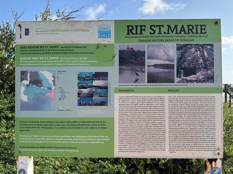
1. Rif St.Marie Marker

(Papiamentu):
Gobièrnu a destiná área di Rif St. Marie komo un área di Ramsar; e tratado internashonal pa protekshon di reanan akuátiko di importansia internashonal.
Ministerio di Salubridat, Medio Ambiente i Naturalesa ta pidi públiko su kolaborashon pa hasi uso di e área úniko aki na un manera responsabel, es desir tene eárea limpi, preferiblemente no kana ku kachó pa no molestiá entre otro e flamingonan, ni usa vehíkulo motorisá denter di e área i piska na un manera responsabel.
Pa mas informashon por bishitá website di Ramsar: www.ramsar.org
E ruina di lanthis Rif-St. Marie ta situá parti pabou di e área. Tabata usa e saliña den pasado pa produsí salute ku añanan 60 di siglo pasá. E zoutpannan tur ta eksistí ainda. A lanta un estatua na Rif-St. Marie pa rekordá e rebelion di e katibunan na ougustùs 1795 na Korsou. Aktualmente ta usa e área pa rekreashon (kana, kore baiskel) i tambe pa ekspedishon di eko- turismo. E komunidat lokal ta konsiderá eárea aki un área balioso pasobra su paisahe ta bunita. Eárea di Rif-St. Marie ta relativamente
this page online
Photographed by Pete Skillman, February 21, 2025
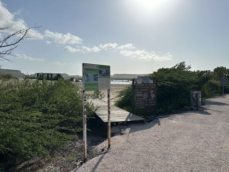
2. Rif St.Marie Marker - wide view
(English):
The Government of Curaçao has designated the Rif St. Marie area for a Ramsar nomination; the international treaty for the protection of wetlands of international importance.
The Ministry of Health, Environment and Nature would like to ask collaboration of all visitors of the area to use the area in a responsible manner, i.e. keep the area clean, preferably do not walk your dog unleashed to not disturb the flamingos, do not use motorized vehicles in the area, and fish in a responsible way.
For more information please visit the Ramsar website: www.ramsar.org
Ruins of the old plantation house Rif-Sint Marie are found on the western part of the area. The saliña was used for salt extraction until the 1960s and saltpans are still present. A statue was erected near Rif-Sint Marie in memory of a slave revolt held in August 1795 on Curaçao. The area is currently used for recreational purposes (hiking, biking) but receives guided eco-tours. It is considered of high scenic value by the local population. The area of Rif-Sint Marie is relatively undisturbed and undeveloped and comprises a saliña of approximately 130 ha, surrounded by mud flats, shrub land and forests. The saliña is a foraging habitat for flamingos and several waterbirds. The coral reef of Rif-Sint Marie is well developed and shelters several threatened coral species (Acropora spp.). The saliña of Rif-Sint Marie is crucial to maintain viable populations of the Caribbean flamingo during the dry season when the larger wetlands of Venezuela (where part of the population forages) run dry. Furthermore, the increased abundance of flamingos on Curaçao since the early 90's suggests that the (growing) breeding population on the nearby island of Bonaire (up to 1,300 pairs nesting in Pekelmeer Saltworks IBA/Breeding Reserve/Ramsar site) is spreading out and has started colonizing suitable habitats on neighboring islands, such as Curaçao. The saliña of Rif-Sint Marie provides important food sources for these flamingos and is part of a network of feeding sites for this species, not only on Curacao itself, but also within the Southern Caribbean Ecoregion. The shallow reefs (0 to 4 m depth) of this Ramsar site harbor dense populations of the Elkhorn coral (Acropora palmata) and large stands of Fire coral (Millepora complanata), which both provide complex structural habitats for specific reef fish species that are crucial for these species as hiding places and nursery habitats. The reef flat adjacent to Boka Sint Marie shelters luxurious coral communities which cover more than 50% of the bottom. Near the entrance alone one can encounter approximately 2.76 hectares of mangroves, especially the black mangroves.
(Captions):
To the left map of the Ramsar area Rif St.Marie. Above some examples of unique flora and fauna of the area and salt ponds: Carribean flamingo, osprey's, and elkhorn coral.
Left: Great blue heron.
Middle: Mangrove forest at entrance of the salina.
Right: Historical limestone oven near entrance channel to salina.
Erected by Curacao Ministry of Health, Environment and Nature.
Topics. This historical marker is listed in these topic lists: Animals • Industry & Commerce • Parks & Recreational Areas • Settlements & Settlers.
Location. 12° 12.79′ N, 69° 3.171′ W. Marker is in Jan Kok, Curaçao (Curaçao). It is on Weg naar St Willibrordus, on the right when traveling east. Touch for map. Marker is at or near this postal address: Weg naar St Willibrordus 1b, Jan Kok, Curaçao, Dutch Caribbean. Touch for directions.

Regionally, it is one of the Lesser Antilles on the Caribbean Sea, on in the Atlantic Ocean, and in North America.
Other nearby markers. At least 8 other markers are within 18 kilometers of this marker, measured as the crow flies: 1st Battle won by Freedom Fighters (about 120 meters away, measured in a direct line); Headquarters & Meeting with Father Schinck (approx. 1.9 kilometers away); Area Information: Rif St Marie (approx. 3.2 kilometers away); USS Erie PG-50 (approx. 14.6 kilometers away); Tribute to the Martyrs of 1795 (approx. 16.2 kilometers away); Tula's Rehabilitation Monument (approx. 16.2 kilometers away); Tula Freedom Monument (approx. 16.3 kilometers away); Free at Last (approx. 16.3 kilometers away).
Also see . . .
1. Ramsar - The Convention of Wetlands. This area is protected wetlands under the Ramsar Convention. The Ramsar website is mentioned on the marker itself. (Submitted on March 1, 2025, by Pete Skillman of Wilmington, Delaware.)
2. Rif-Sint Marie - Ramsar Sites Information Service.
Rif-Sint Marie. 05/02/2013. Curaçao; 667 ha; 12°12'16"N 069°03'16"W. Conservation Area, Important Bird Area. The area of Rif-Sint Marie is relatively undisturbed and undeveloped and comprises a salt mash surrounded by mud flats, shrub land, and forests. The marsh is a strategic feeding habitat for flamingos and several waterbirds.(Submitted on March 1, 2025, by Pete Skillman of Wilmington, Delaware.)
Credits. This page was last revised on March 5, 2026. It was originally submitted on February 26, 2025, by Pete Skillman of Wilmington, Delaware. This page has been viewed 186 times since then and 39 times this year. Photos: 1, 2. submitted on February 26, 2025, by Pete Skillman of Wilmington, Delaware.
