Nashville in Davidson County, Tennessee — The American South (East South Central)
Richland Creek Greenway
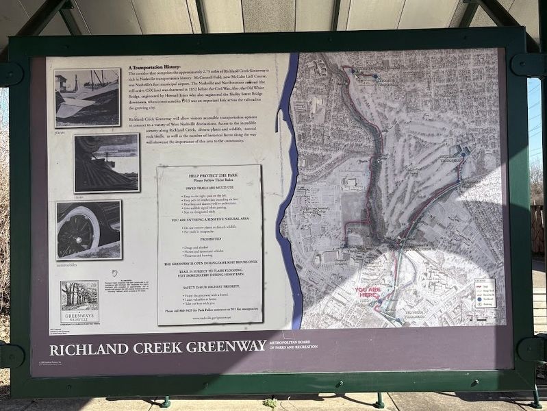
A Transportation History
Photographed by Darren Jefferson Clay, March 2, 2025
1. Richland Creek Greenway Marker
The corridor that comprises the approximately 2.75 miles of Richland Creek Greenway is rich in Nashville transportation history. McConnell Field, now McCabe Golf Course, was Nashville's first municipal airport. The Nashville and Northwestern railroad (the still active CSX line) was chartered in 1852 before the Civil War. Also, the Old White Bridge, engineered by Howard Jones who also engineered the Shelby Street Bridge downtown, when constructed in 1913 was an important link across the railroad to the growing city.
Richland Creek Greenway will allow visitors accessible transportation options to connect to a variety of West Nashville destinations. Access to the incredible scenery along Richland Creek, diverse plants and wildlife, natural rock bluffs, as well as the number of historical facets along the way will showcase the importance of this area to the community.
Help Protect the Park
Please Follow These Rules
Paved trails are multi-use
•Keep to the right, pass on the left.
•Keep pets on leashed not exceeding six feet.
•Bicycling and skaters yield to pedestrians.
•Give audible signal
this page online
•Stay on designated trails.
You are entering a sensitive natural area.
•Do not remove plants or disturb wildlife.
• Put trash in receptacles.
Prohibited
•Drugs and alcohol
•Horses and motorized vehicles
•Firearm and hunting
The greenway is open during daylight hours only. Trail is subject to flash flooding. Exit immediately during heavy rain.
•Safety is our highest priority
Enjoy the greenway with a friend.
Leave valuable at home.
Take car keys with you.
Please call 880-3429 for Park Police assistance or 911 for emergencies.
www.nashville.gov/greenways
Erected by Metropolitan Board of Parks and Recreation.
Topics. This historical marker is listed in these topic lists: Air & Space • Bridges & Viaducts • Parks & Recreational Areas • Railroads & Streetcars. A significant historical year for this entry is 1852.
Location. 36° 7.664′ N, 86° 50.976′ W. Marker is in Nashville, Tennessee, in Davidson County. It is on White Bridge Pike, on the right when traveling north. Touch for map. Marker is at or near this postal address: 22 White Bridge Pike, Nashville TN 37205, United States of
Photographed by Darren Jefferson Clay, March 2, 2025
2. Richland Creek Greenway Marker

Regionally, this marker is in Middle Tennessee. It is also in the American South and specifically in the Upper South. Globally, it is in North America, the Western Hemisphere, the Western World, and the Anglosphere. Historically, it finds itself in what was once the territory of the Mississippian Culture, one of the Confederate States of America, and the Antebellum South.
Other nearby markers. At least 8 other markers are within walking distance of this marker: Dutchman’s Curve Train Wreck (about 300 feet away, measured in a direct line); Battle of Nashville (approx. 0.3 miles away); Johnson's Station (approx. 0.6 miles away); Vine Street Christian Church (approx. 0.6 miles away); Hood's Maneuvers (approx. 0.6 miles away); Montgomery Bell Academy (approx. 0.7 miles away); Thayer U.S. Army General Hospital (approx. 0.7 miles away); Kenner Manor Historic District (approx. 0.8 miles away). Touch for a list and map of all markers in Nashville.
Credits. This page was last revised on March 4, 2025. It was originally submitted on March 2, 2025, by Darren Jefferson Clay of Duluth, Georgia. This page has been viewed 254 times since then and 69 times this year. Photos: 1, 2. submitted on March 2, 2025, by Darren Jefferson Clay of Duluth, Georgia. • James Hulse was the editor who published this page.
