East Florence in Lauderdale County, Alabama — The American South (East South Central)
Florence Canal
Photographed by Sandra Hughes Tidwell, March 26, 2025
1. Florence Canal Marker
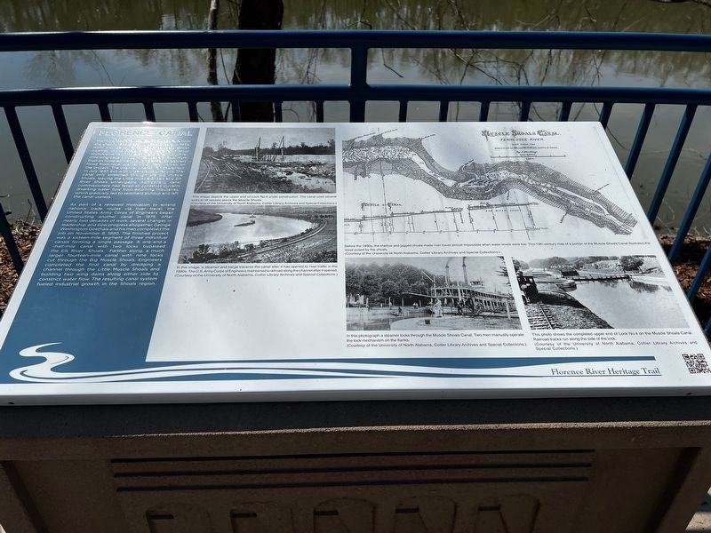
As part of a renewed motivation to extend national trade routes via river travel, the United States Army Corps of Engineers began construction another canal in 1875. After nearly two decades of work, several changes in leadership, and slow progress altogether, Goerge Washington Goethals and his men completed the job on November 8, 1890. The finished project was a sixteen-mile segment of three individual
this page online
Captions
(Photo #1) This image depicts the upper end of Lock No. 4 under construction. The canal used several locks to lift vessels above the Muscle Shoals. (Courtesy of the University of North Alabama, Collier Library Archives and Special Collections)
(Photo #2) In this image, a steamer and a barge traverse the canal after it has opened to river traffic in the 1890s. The U.S. Army Corps of Engineers maintained a railroad along the channel after it opened. (Courtesy of the University of North Alabama, Collier Library Archives and Special Collections)
(Photo #3) Before the 1890s, the shallow and jagged shoals made river travel almost impossible when water levels were low. This 19th-century map of a portion of the Muscle Shoals Canal illustrates the issue posed by the shoals. (Courtesy of the University of North Alabama, Collier Library Archives and Special Collections)
(Photo #4) In this photograph, a steamer locks through the Muscle Shoals Canal. Two men manually operate the lock mechanism on the flanks. (Courtesy of the University of North Alabama, Collier Library Archives and Special Collections)
(Photo #5) This photo shows the completed upper end of Lock No. 4 on the Muscle Shoals Canal. Railroad tracks run along the side of the lock. (Courtesy of the University of North Alabama, Collier Library Archives and Special Collections)
Erected by Florence
Photographed by Sandra Hughes Tidwell, March 26, 2025
2. Florence Canal Marker
Topics. This historical marker is listed in this topic list: Waterways & Vessels. A significant historical month for this entry is July 1837.
Location. 34° 48.158′ N, 87° 38.279′ W. Marker is in Florence, Alabama, in Lauderdale County. It is in East Florence. It is on South Oneal Street. Touch for map. Marker is at or near this postal address: 725 S Oneal St, Florence AL 35630, United States of America. Touch for directions.

Regionally, this marker is in North Alabama and in the Shoals. It is also in the American South, specifically in the Deep South, in Appalachia, and specifically in Southern Appalachia. Globally, it is in North America, a Gulf of Mexico state, the Western Hemisphere, the Western World, and the Anglosphere. Historically, it finds itself in what was once the territory of the Mississippian Culture, one of the Confederate States of America, and the Antebellum South.
Other nearby markers. At least 8 other markers are within walking distance of this marker: Wagon Works (approx. 0.2 miles away); Wilson Dam Lock (approx. ¼ mile away); Natural History (approx. ¼ mile away); Tennessee Valley Authority (approx. 0.4 miles away); Wilson Dam (approx. 0.4 miles away); Charles Caine Anderson (approx. 0.4 miles away); Florence Wagon Company (approx. 0.4 miles away); Lt. Col. R. Edward Yeilding (approx. 0.4 miles away). Touch for a list and map of all markers in Florence.
Credits. This page was last revised on April 1, 2025. It was originally submitted on March 27, 2025, by Sandra Hughes Tidwell of Killen, Alabama, USA. This page has been viewed 358 times since then and 88 times this year. Photos: 1, 2. submitted on March 27, 2025, by Sandra Hughes Tidwell of Killen, Alabama, USA. • James Hulse was the editor who published this page.
