East Florence in Lauderdale County, Alabama — The American South (East South Central)
Native American
Chokma! (Hello in Chickasaw)
Photographed by Sandra Hughes Tidwell, March 26, 2025
1. Native American Chokma! (Hello in Chickasaw) Marker
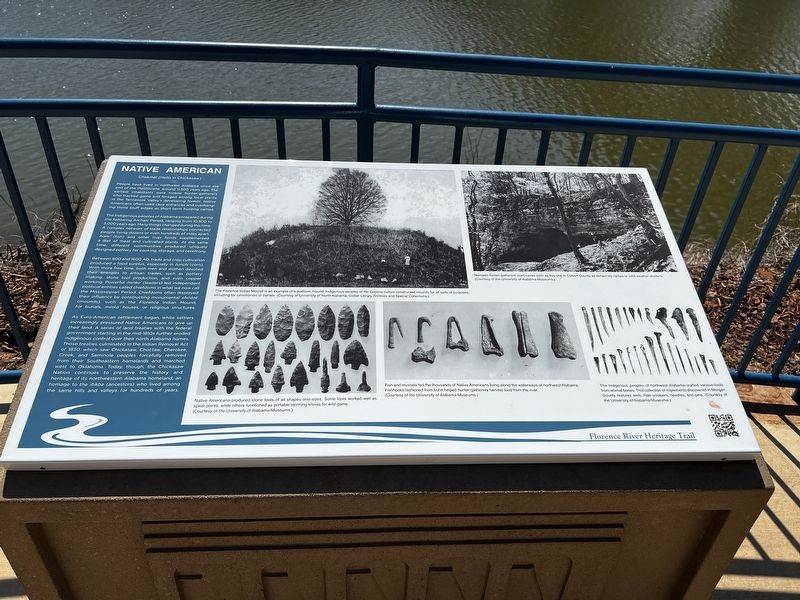
The indigenous people of Alabama prospered during the following Archaic Period, ranging from 10,500 to 3,000 years ago. Many things changed during this time. A complex network of trade relationships connected people living down or even hundreds of miles apart. Nani` (fish) and other river foods supplemented a diet of meat and cultivated plants. At the same time, different communities produced uniquely designed pottery for cooking, storage, and ceremony.
Between 800 and 1600 AD, trade and crop cultivation produced a food surplus, especially in tunchi (corn). With more free time, men and women devoted their energies to artisan trades, such as pottery making, stone tool production, and even copper working. Powerful minko (leaders) led independent political entities called
this page online
As Euro-American settlement began, white settlers increasingly pressured Native Americans to give up their land. A series of land treaties with the federal government starting in the mid-1810s further eroded indigenous control over their North Alabama homes. Those treaties culminated in the Indian Removal Act of 1830, which saw Chickasaw, Choctaw, Cherokee, Creek, and Seminole peoples forcefully removed from their Southeastern homelands and marched west to Oklahoma. Today, though, the Chickasaw Nation continues to preserve the history and heritage of its northwestern Alabama homeland, an homage to the itikba (ancestors) who lived among the same hills and valleys for hundreds of years.
Captions
(Photo #1) The Florence Indian Mound is an example of a platform mound. Indigenous peoples of the Copena culture constructed mounds for all sorts of purposes, including for ceremonies or burials. (Courtesy of University of North Alabama, Collier Library Archives and Special Collections)
(Photo #2) Native Americans produced stone tools of all shapes and sizes. Some tools worked well as spear points, while others functioned as portable skinning knives for wild game. (Courtesy of the University of Alabama Museums)
(Photo #3) Fish and mussels fed the thousands of Native Americans living along the waterways of northwest Alabama. Bone fishhooks helped hunter-gatherers harvest food from the river. (Courtesy of the University of Alabama Museums)
(Photo #4) Nomadic hunter-gatherers used caves such as this one in Colbert County as temporary camps or cold-weather shelters. (Courtesy of the University of Alabama Museums)
(Photo #5) The Indigenous people of northwest Alabama crafted various tools from animal bones. This collection of implements discovered in Morgan County features awls, hide scrapers, needles, and pins. (Courtesy of the University of Alabama Museums)
Erected by Florence
Photographed by Sandra Hughes Tidwell, March 26, 2025
2. Native American Chokma! (Hello in Chickasaw) Marker
Topics. This historical marker is listed in this topic list: Indigenous Peoples and Communities. A significant historical year for this entry is 600 CE.
Location. 34° 48.009′ N, 87° 38.942′ W. Marker is in Florence, Alabama, in Lauderdale County. It is in East Florence. It is on Industry Street. Touch for map. Marker is at or near this postal address: 630 Industry St, Florence AL 35630, United States of America. Touch for directions.

Regionally, this marker is in North Alabama and in the Shoals. It is also in the American South, specifically in the Deep South, in Appalachia, and specifically in Southern Appalachia. Globally, it is in North America, a Gulf of Mexico state, the Western Hemisphere, the Western World, and the Anglosphere. Historically, it finds itself in what was once the territory of the Mississippian Culture, one of the Confederate States of America, and the Antebellum South.
Other nearby markers. At least 8 other markers are within walking distance of this marker: Maud McKnight Lindsay (approx. 0.3 miles away); Wagon Works (approx. half a mile away); Florence Wagon Company (approx. half a mile away); East Florence Historic District (approx. 0.6 miles away); Florence Canal (approx. 0.7 miles away); Cotton and Textile Mills (approx. 0.7 miles away); General Hood's Narrow Escape (approx. 0.8 miles away); Old Confederate Fort (approx. 0.8 miles away). Touch for a list and map of all markers in Florence.
Credits. This page was last revised on April 1, 2025. It was originally submitted on March 27, 2025, by Sandra Hughes Tidwell of Killen, Alabama, USA. This page has been viewed 166 times since then and 21 times this year. Photos: 1, 2. submitted on March 27, 2025, by Sandra Hughes Tidwell of Killen, Alabama, USA. • James Hulse was the editor who published this page.
