Castile in Wyoming County, New York — The American Northeast (Mid-Atlantic)
The Iroquois Confederacy
Photographed by Susan A. Dalaba, August 12, 2021
1. The Iroquois Confederacy Marker
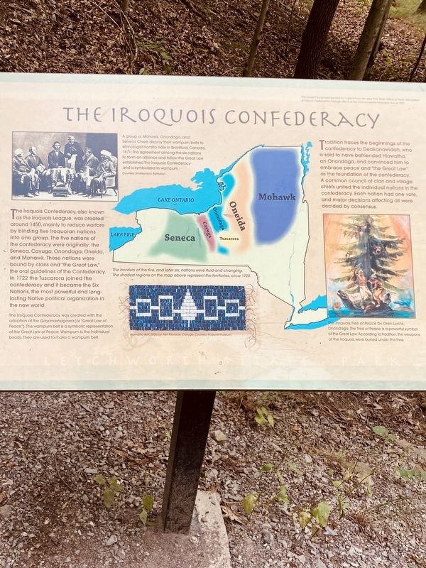
The Iroquois Confederacy, also known as the Iroquois League, was created around 1450, mainly to reduce warfare by binding five Iroquoian nations into one group. The five nations of the confederacy were originally: the Seneca, Cayuga, Onondaga, Oneida, and Mohawk. These nations were bound by clans and “the Great Law,” the oral guidelines of the Confederacy. In 1722, the Tuscarora joined the confederacy and it became the Six Nations, the most powerful and long lasting Native political organization in the new world.
Tradition traces the beginnings of the confederacy to Deakanawidah, who is said to have befriended Hiawatha, an Onondaga, and convinced him to embrace peace and “the Great Law” as the foundation of the confederacy. A common council of clan and village chiefs united the individual nations in the confederacy. Each nation had one vote, and the major decisions affecting all were decided by consensus.
[Captions:]
A group of Mohawk, Onondaga, and Seneca Chiefs display their wampum belts to ethnologist Horatio Hale in Brantford, Canada, 1871. The agreement among the six nations to form an alliance and follow the Great Law established the Iroquois Confederacy and is symbolized in wampum. (Courtesy Smithsonian Institution)
The borders of the five, and later six, nations were fluid and changing. The shaded regions on the map above represent the territories, circa 1720.
The Iroquois Confederacy was created with the adoption of the Gayanashagowa (or “Great Law of Peace”). This wampum belt is a symbolic representation of the Great Law of Peace. Wampum is the individual beads. They are used to make a wampum belt.
The Iroquois Tree of Peace by Oren Lyons, Onondaga. The Tree of Peace is a powerful symbol of the Great Law. According to tradition, the weapons of the Iroquois were buried under this tree.
Topics.
this page online
Location. 42° 35.173′ N, 78° 2.587′ W. Marker is in Castile, New York, in Wyoming County. It can be reached from Park Road. Placard is on the Council Grounds Trail between the Council Grounds and the William Pryor Letchworth Museum. Touch for map. Marker is at or near this postal address: 6514 Park Rd, Castile NY 14427, United States of America. Touch for directions.

Regionally, this marker is in Upstate New York, specifically in Western New York, and in the Finger Lakes. It is also in the American Northeast and in the Mid-Atlantic. Globally, it is in North America, the Western Hemisphere, the Western World, and the Anglosphere. Historically, it finds itself in what was once the Haudenosaunee (Iroquois) Confederacy, New Netherland, and one of the original Thirteen Colonies.
Other nearby markers. At least 8 other markers are within walking distance of this marker: Mary Jemison (within shouting distance of this marker); Welcome to the Seneca Council Grounds (within shouting distance of this marker); The Council Grounds Ca. 1907...and Under Restoration (within shouting distance of this marker); Nancy Jemison Log Cabin (within shouting distance of this marker); Iroquois Clans (within shouting distance of this marker); To the Memory of Mary Jemison (within shouting distance of this marker); This Ancient Seneca Council House (within shouting distance of this marker); In Grateful Memory of William Pryor Letchworth (about 800 feet away, measured in a direct line).
Credits. This page was last revised on April 21, 2025. It was originally submitted on March 29, 2025, by Susan A. Dalaba of Cortland, New York. This page has been viewed 236 times since then and 50 times this year. Photo 1. submitted on March 29, 2025, by Susan A. Dalaba of Cortland, New York. • Devry Becker Jones was the editor who published this page.
Editor’s want-list for this marker. Verification of the geocoordinates. • A wide shot of the marker in context. • Can you help?
