Decatur in Morgan County, Alabama — The American South (East South Central)
The Land of the Indians
1773
Photographed by Sandra Hughes Tidwell, March 25, 2025
1. The Land of the Indians 1773 Marker
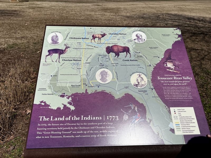
Early historians called the Tennessee River Valley "The most wonderful game preserve ever to exist upon the earth."
In the 1700's buffalo roamed over the plains of the Tennessee River Valley in countless numbers. Their paths were knee deep and radiated in every direction from the many licks in the county. Deer, elk, and wild turkeys were abundant, with as many as sixty deer counted in a single herd. The Tennessee River swarmed with fish, and its bottom was strewn with mussels and periwinkle.
Early Settlers of Alabama by James Edmonds Sanders and Elizabeth Saunders Blair Stubbs.
Legend
• Indian Town
• Colonial Town
• Fort
• Path
• Treaty Boundary Line
• British/Spanish Boundary
• Modern State Border
• Modern Alabama Border
• Tennessee River
• Creek/Seminole Nation
• British Colony
• Choctaw/Chickasaw/Cherokee Nations
Drawings of Chiefs
• Cherokee Nation - Chief Ostenaco of the Cherokee
• Chickasaw Nation - Chickasaw War Chief
• Creek Nation - Creek War Chief
• Seminoles - Mico Chlucco, King of the Seminoles
Topics.
this page online
Location. 34° 35.844′ N, 86° 58.625′ W. Marker is in Decatur, Alabama, in Morgan County. It is at the intersection of Gordon Drive Southeast and 8th Ave SE on Gordon Drive Southeast. Marker is near the Children's playground in Delano Park. Touch for map. Marker is at or near this postal address: 825 Gordon Dr SE, Decatur AL 35601, United States of America. Touch for directions.

Regionally, this marker is in North Alabama. It is also in the American South, specifically in the Deep South, in Appalachia, and specifically in Southern Appalachia. Globally, it is in North America, a Gulf of Mexico state, the Western Hemisphere, the Western World, and the Anglosphere. Historically, it finds itself in what was once the original Cherokee Nation, the territory of the Mississippian Culture, one of the Confederate States of America, and the Antebellum South.
Other nearby markers. At least 8 other markers are within walking distance of this marker: Health and Civic Welfare (within shouting distance
Photographed by Darren Jefferson Clay, July 26, 2025
2. The Land of the Indians Marker
Also see . . .
1. Decatur, Alabama. Wikipedia entry (Submitted on July 21, 2026, by Larry Gertner of New York, New York.)
2. Ostenaco. Wikipedia entry:
Ostenaco, headman of Tommotley, also known as (Mankiller) and ‘Judd’s or Judge’s Friend,’ was a prominent chief during the Cherokee Wars, a rival of Attakullakulla. (Submitted on October 7, 2025, by Larry Gertner of New York, New York.)
Credits. This page was last revised on July 21, 2026. It was originally submitted on April 6, 2025, by Sandra Hughes Tidwell of Killen, Alabama, USA. This page has been viewed 294 times since then and 80 times this year. Photos: 1. submitted on April 6, 2025, by Sandra Hughes Tidwell of Killen, Alabama, USA. 2. submitted on August 8, 2025, by Darren Jefferson Clay of Duluth, Georgia. • James Hulse was the editor who published this page.
