Vieux-Québec-Cap-Blanc-colline Parlementaire in Capitale-Nationale, — Central Canada (French-Canadian)
Citadelle Temporaire
⎯⎯⎯
Temporary Citadel
(1779-1783)
Photographed by Cosmos Mariner, August 3, 2019
1. Citadelle Temporaire / Temporary Citadel Marker

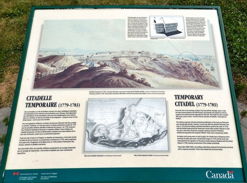
Pour les ingénieurs militaires, le secteur du Cap-aux-Diamants doit être protégé en priorité. Toutefois, ce n'est que suite à l'invasion américaine avortée de 1775 que les autorités militaires décident d'effectuer les travaux : en 1778, le gouverneur Frederick Haldimand demande à l'ingénieur William Twiss d'ériger une citadelle temporaire. En fait, les Britanniques craignent une autre tentative de la part des Américains, autant qu'un soulèvement populaire.
Faute de main-d'œuvre et d'argent, la citadelle est temporaire, c'est-à-dire qu'elle est faite de terre et de bois. La construction commence en 1779, mais la signature de la paix entre l'Angleterre et les États-Unis en 1783 entraîne l'interruption des travaux, laissant la citadelle
this page online
Plus tard (1820-1831), les autorités militaires remplacèrent cet ouvrage temporaire par un ouvrage de maçonnerie, c'est-à-dire la citadelle que nous connaissons aujourd'hui.
The military engineers felt that protecting fortification of the Cap-aux-Diamants area should take priority. However, it was only after the abortive American invasion in 1775 that the military authorities decided to perform the work. In 1778, with the British fearing that the Americans would make another attempt to take the city or that there would be a popular uprising, Governor Frederick Haldimand requested that engineer William Twiss erect a temporary citadel.
As labour and money were in short supply, the citadel was a temporary structure built of earth and wood. Construction began in 1779, but the work was interrupted

J. Peachey, 1784, Library and Archives Canada
2. Marker detail: Citadelle temporaire / Temporary citadel
L'ouvrage était situé un peu plus à l'ouest que le citadelle actuelle. • • • The structure extended a little farther west than the present-day citadel.
Years later (1820-1831), the military authorities replaced the temporary structure with a masonry structure. This is the citadel that we know today.
Erected by Commission des champs de bataille nationaux/The National Battlefields Commission.
Topics. This historical marker is listed in these topic lists: Architecture • Colonial Era • Forts and Castles • War, US Revolutionary. A significant historical year for this entry is 1779.
Location. 46° 48.232′ N, 71° 12.91′ W. Marker is in Québec, in Capitale-Nationale. It is in Vieux-Québec-Cap-Blanc-colline Parlementaire. It can be reached from Avenue George VI 0.2 kilometers east of Avenue Taché, on the left when traveling west. The marker is located along the Plains of Abraham walking path, about 100 yards south of Avenue George VI, overlooking the St. Lawrence River. Touch for map. Marker is at or near this postal address: Avenue George VI, Québec G1R 2L4, Canada. Touch for directions.

Regionally, this marker is in Central Canada. Globally,

National Battlefields Commission Archives
3. Marker detail: Blockhaus / Blockhouse
Cette illustration de James Peachey permet d'entrevoir un blockhaus dont les vestiges ont été mis à jour par le biais de fouilles archéologiques. Il aurait été construit en 1782 par les autorités britanniques et intégré à la citadelle temporaire (1779-1783). Ses fondations étaient en maçonnerie et ses murs en bois, montés pièce sur pièce. Le blockhaus aurait surtout été occupé lors de la guerre de 1812, alors que Britanniques et Américains s'opposaient et que la ville était en alerte. • • • This illustration by James Peachey shows a blockhouse, the vestiges of which were brought to light in an archaeological dig. It is believed to have been built by British authorities in 1782 and integrated into the temporary citadel (1779-1783). It had a masonry foundation and log walls. The structure would have been occupied during the War of 1812, when the British faced off against the Americans and the city was on high alert.
Other nearby markers. At least 8 other markers are within walking distance of this marker: Le Siège de Québec, 1759 / The Siege of Québec, 1759 (a few steps from this marker); A Golf Club on the Plains of Abraham (about 150 meters away, measured in a direct line); Do You Know Joan of Arc? (about 180 meters away); O Canada! (about 180 meters away); Calibre: 15 cm schwere Feldhaubitze 02 (about 210 meters away); Calibre: 21 cm Mörser 16 (about 240 meters away); Calibre: 10.5 cm Leichte Feldhaubitze 16 (about 240 meters away); Calibre: 7.7 cm Feldkanone 96 neuer Art (approx. 0.2 kilometers away). Touch for a list and map of all markers in Québec.
Also see . . .
1. Fortifications of Québec National Historic Site (Parks Canada).
Excerpt: Shortly after the Conquest of Canada, the British victors were faced with new defence requirements. From 1760 to 1775, military authorities feared a reaction(Submitted on April 11, 2025, by Cosmos Mariner of Cape Canaveral, Florida.)from the Francophone population. Furthermore, they were concerned that France would try to recapture Québec. Due to England's economic woes, Québec's defence system was not to be strengthened. Instead, the British took the necessary precautions to preserve the fortifications. One idea nevertheless prevailed: a citadel had to be built. The city's enceinte, deemed inadequate, was virtually ignored for a quarter of a century. American Revolution gave rise to the British's first project. Between 1778 and 1783, the army set up a series of wood and earth works, which formed a réduit along the heights of Cape Diamond. Based upon William Twiss' plans, these works were designated as Québec's "temporary citadel."Library and Archives Canada4. Marker detail: Plan de la citadelle temporaire, 1783 /
Plan of the temporary citadel

2. Citadelle of Quebec (Wikipedia).
Excerpt: Cap Diamant's strategic value was identified by Samuel de Champlain in 1608 and led him to found Quebec City at the base of the escarpment. The promontory was practically insurmountable and thus the only side of the settlement ever to be heavily fortified was the west, the only one not naturally(Submitted on April 11, 2025, by Cosmos Mariner of Cape Canaveral, Florida.)protected by the hill.Photographed by Cosmos Mariner, August 3, 20195. Citadelle Temporaire / Temporary Citadel MarkerLooking northeast from the walking path, across the citadel site. The St. Lawrence River is obscured by trees in the background.
During the American Revolutionary War, after seizing Montreal in the autumn of 1775, American rebels, led by General Richard Montgomery and Benedict Arnold, attempted to take Quebec on 31 December. There, Montgomery was killed and Arnold wounded and forced to retreat.
As tensions between the United Kingdom and the United States, as well as fears of further rebellion in British North America, grew in the late 18th century, the British reinforced the defences of their colonies according to a plan drawn up in the 1790s by Gother Mann. A citadel was a key part of Mann's design, but no fort was built because the cost was deemed prohibitive. That opinion finally shifted following the War of 1812…

Credits. This page was last revised on April 11, 2025. It was originally submitted on April 8, 2025, by Cosmos Mariner of Cape Canaveral, Florida. This page has been viewed 117 times since then and 23 times this year. Photos: 1, 2, 3, 4, 5. submitted on April 11, 2025, by Cosmos Mariner of Cape Canaveral, Florida.
