Clinton in Laurens County, South Carolina — The American South (South Atlantic)
Duncan Creek Presbyterian Church
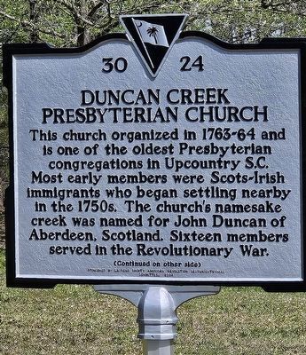
Photographed by Yvonne Vaughn, April 11, 2025
1. Duncan Creek Presbyterian Church Marker, side one
The oldest known grave in the church cemetery dates to 1776. Tradition holds members first worshipped in a log building at this site. The extant stone church was built in 1842 and renovated in 1927, when an original gallery used by enslaved people was removed. Listed in the National Register of Historic Places in 1973.
Erected 2024 by Laurens County American Revolution Sestercentennial Committee. (Marker Number 30 24.)
Topics. This historical marker is listed in these topic lists: Cemeteries & Burial Sites • Religion & Religious Structures. A significant historical year for this entry is 1764.
Location. 34° 31.208′ N, 81° 48.486′ W. Marker is in Clinton, South Carolina, in Laurens County. It is on Golden Acres Road 0.8 miles east of Barrel Stave Road (County Route 44-22),
this page online

Regionally, this marker is in Upstate. It is also in the American South and specifically in the Deep South. Globally, it is in North America, the Western Hemisphere, the Western World, and the Anglosphere. Historically, it finds itself in what was once the territory of the Mississippian Culture, one of the original Thirteen Colonies, one of the Confederate States of America, and the Antebellum South.
Other nearby markers. At least 8 other markers are within 6 miles of this marker, measured as the crow flies: Pinelawn Memory Gardens Veterans Monument (approx. 5.1 miles away); Eugene Blakely Sloan (1922-1969) - Eugene Blakely Sloan (approx. 5.1 miles away); A Piece of Musgrove's Mill (approx. 5.1 miles away); Eugene Blakely Sloan (approx. 5.1 miles away); Broad Street Methodist Church (approx. 5.2 miles away); Clinton Confederate Monument (approx. 5.2 miles away); Clinton Veterans Monument (approx.
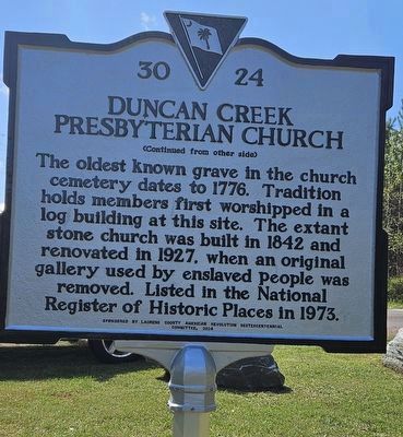
Photographed by Yvonne Vaughn, April 11, 2025
2. Duncan Creek Presbyterian Church Marker, side two

Photographed by Yvonne Vaughn, April 11, 2025
3. Duncan Creek Presbyterian Church Marker with the Church and Cemetery in the Distance
Credits. This page was last revised on July 20, 2025. It was originally submitted on April 11, 2025, by Yvonne Vaughn of Elgin, South Carolina. This page has been viewed 315 times since then and 59 times this year. Photos: 1, 2, 3. submitted on April 11, 2025, by Yvonne Vaughn of Elgin, South Carolina. • J. J. Prats was the editor who published this page.
