Green Township near Loudonville in Ashland County, Ohio — The American Midwest (Great Lakes)
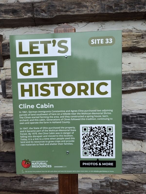
Cline Cabin
Let's Get Historic
Photographed by Craig Doda, April 5, 2025
1. Cline Cabin Marker
In 1947, the State of Ohio purchased the property, and it became part of the Mohican-Memorial State Forest. By 1979, the Cline Cabin was in danger of falling into disrepair and moved to this location. Today, it is a link to a time when people used this land and its resources to grow crops and provide raw materials to feed and shelter their families.
Erected by Ohio Department Of Natural Resources. (Marker Number Site 33.)
Topics. This historical marker is listed in these topic lists: Agriculture • Architecture • Settlements & Settlers. A significant historical year for this entry is 1861.
Location. 40° 36.614′ N, 82° 15.572′ W. Marker is near Loudonville, Ohio, in Ashland County. It is in Green Township. It is at the intersection of Ohio Route
this page online

Regionally, this marker is in Amish Country. It is also in the American Midwest. Globally, it is in North America, the Western Hemisphere, the Western World, and the Anglosphere. Historically, it finds itself in what was once the Haudenosaunee (Iroquois) Confederacy, the territory of the Mississippian Culture, and the Northwest Territory.
Other nearby markers. At least 8 other markers are within walking distance of this marker: Loudonville (approx. 0.4 miles away); High Water Mark (approx. 0.4 miles away); The Smokehouse (approx. half a mile away); The Outhouse (approx. half a mile away); The Corn Crib (approx. 0.6 miles away); The Henhouse (approx. 0.6 miles away); The Sorghum Press (approx. 0.6 miles away); The Plow (approx. 0.6 miles away). Touch for a list and map of all markers in Loudonville.

Photographed by Craig Doda, April 5, 2025
2. Cline Cabin Marker

Photographed by Craig Doda, April 5, 2025
3. Cline Cabin Marker
Credits. This page was last revised on April 18, 2025. It was originally submitted on April 11, 2025, by Craig Doda of Napoleon, Ohio. This page has been viewed 127 times since then and 35 times this year. Photos: 1, 2, 3. submitted on April 11, 2025, by Craig Doda of Napoleon, Ohio. • Andrew Ruppenstein was the editor who published this page.
