Crab Orchard in Cumberland County, Tennessee — The American South (East South Central)
Tennessee Civil War Trails
Create Some History of Your Own

Photographed by Mark Parker, March 27, 2025
1. Tennessee Civil War Trails Marker
Get ready to visit small towns with big stories.
Tennessee Civil War Trails tells riveting stories of battles and leaders, and much more. You'll learn about some of the state's 275,000 enslaved men and women who self-emancipated, and the 20,000 self-liberated warriors who fought for freedom in the U.S. Colored Troops.
Your explorations will take you to houses and mills that played a role in the war, and small towns and farms where families found themselves swept up in the conflict. Some communities found themselves divided over secession and slavery, causing a "war within a war" that left deep, lingering scars.
Though the state seceded and supplied 120,000 soldiers to Confederate armies, United States sentiment was also strong here, particularly in the eastern part of the state. 31,000 white Tennesseans fought for the Union, more than any other Confederate state. And more battles were fought in Tennessee than any other state except Virginia.
Enjoy scenic byways, historic main streets, rivers and railroads, and explore the fascinating stories all around you. Walk in the footsteps
this page online
(Captions)
Federal artillery in East Tennessee mountains, Harper's Weekly, Nov. 21, 1863
Guerillas attacking train Courtesy Tennessee State Library & Archives
Topics. This historical marker is listed in this topic list: War, US Civil. A significant historical date for this entry is November 21, 1863.
Location. 35° 55.71′ N, 84° 54.829′ W. Marker is in Crab Orchard, Tennessee, in Cumberland County. It is on Interstate 40 at milepost 326, 2½ miles west of Market Street, on the right when traveling west. The marker is at the Cumberland County I-40 West Rest Area, west of Exit 329. Touch for map. Marker is at or near this postal address: 32650 40 W, Crossville TN 38571, United States of America. Touch for directions.

Regionally, this marker is in Tennessee’s Cumberland Plateau. It is also in the American South, specifically in the Upper South, in Appalachia, and specifically in Southern Appalachia. Globally, it is in North America, the Western Hemisphere, the Western World, and the Anglosphere. Historically,

Photographed by Mark Parker, March 27, 2025
2. Tennessee Civil War Trails Marker in front to the Rest Area building
Other nearby markers. At least 8 other markers are within 6 miles of this marker, measured as the crow flies: Kemmer Stand / Tavern (a few steps from this marker); Veteran's Memorial (approx. 1.7 miles away); a different marker also named Tennessee Civil War Trails (approx. 2.1 miles away); Cumberland Homesteads Historic District (approx. 4.3 miles away); Cumberland County Families (approx. 5.1 miles away); Thomas "Big Foot" Spencer (approx. 5.1 miles away); Cumberland Mountain State Park Bridge (approx. 5.1 miles away); a different marker also named Veterans Memorial (approx. 5½ miles away). Touch for a list and map of all markers in Crab Orchard.
Other markers no longer nearby. Champ Ferguson (was within shouting distance of this marker but has been replaced with another marker now near it); "Tinker Dave" Beaty (was approx. 2.1 miles away but has been permanently removed).
Photographed by Mark Parker, March 27, 2025
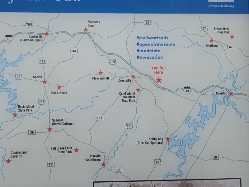
3. Map of other Tennessee Civil War Trails Marker
Credits. This page was last revised on April 14, 2025. It was originally submitted on April 14, 2025, by Mark Parker of Hickory, North Carolina. This page has been viewed 243 times since then and 35 times this year. Photos: 1, 2, 3. submitted on April 14, 2025, by Mark Parker of Hickory, North Carolina. • James Hulse was the editor who published this page.
