Hartford in Cocke County, Tennessee — The American South (East South Central)
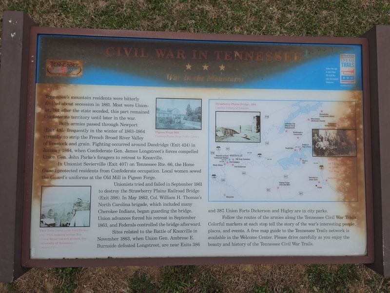
Civil War in Tennessee
War in the Mountains
| — | Tennessee Civil War Trails | — |
Photographed by Mark Parker, March 27, 2025
1. Civil War in Tennessee Marker
Both armies passed through Newport (Exit 435) frequently in the winter of 1863-1864 virtually to strip the French Broad River Valley of livestock and grain. Fighting occurred around Dandridge (Exit 424) in January 1864, when Confederate Gen. James Longstreet's forces compelled Union Gen. John Parke's foragers to retreat to Knoxville.
In Unionist Sevierville (Exit 407) on Tennessee Rte. 66, the Home Guard protected residents from Confederate occupation. Local women sewed the Guard's uniforms at the Old Mill in Pigeon Forge.
Unionists tried and failed in September 1861 to destroy the Strawberry Plains Railroad Bridge (Exit 398). In May 1862, Col. William H. Thomas's North Carolina brigade, which included many Cherokee Indians, began guarding the bridge. Union advances forced his retreat in September 1863, and Federals controlled the bridge afterward.
Sites related to the Battle of Knoxville in November 1863, when Union
this page online
Follow the routes of the armies along the Tennessee Civil War Trails. Colorful markers at each stop tell the story of the war's interesting people, places, and events. A free map guide to the Tennessee Trails network is available in the Welcome Center. Please drive carefully as you enjoy the beauty and history of the Tennessee Civil War Trails.
(Captions)
View from camp near Fort Dickerson, 1864, looking across Tennessee River towards present day University of Tennessee Courtesy Library of Congress
Pigeon Forge Mill courtesy Pigeon Forge Public Library
Strawberry Plains Bridge, 1864courtesy Library of Congress
Topics. This historical marker is listed in this topic list: War, US Civil. A significant historical year for this entry is 1861.
Location. 35° 49.148′ N, 83° 9.542′ W. Marker is in Hartford, Tennessee, in Cocke County. It is on Interstate 40 at milepost 446 west of Big Creek Road, on the right when traveling west. Marker is at the Tennessee Welcome Center, west of Exit 447. Touch for map. Marker

Photographed by Mark Parker, March 27, 2025
2. Civil War in Tennessee Marker, near the parking lot for the Tennessee Welcome Center

Regionally, this marker is in East Tennessee and in the Great Smoky Mountains. It is also in the American South, specifically in the Upper South, in Appalachia, and specifically in Southern Appalachia. Globally, it is in North America, the Western Hemisphere, the Western World, and the Anglosphere. Historically, it finds itself in what was once the original Cherokee Nation, the territory of the Mississippian Culture, one of the Confederate States of America, the State of Franklin, and the Antebellum South.
Other nearby markers. At least 8 other markers are within 10 miles of this marker, measured as the crow flies: Tennessee Veterans Memorial (a few steps from this marker); Ben W. Hooper (approx. 4.7 miles away); A Hidden Family Quilt During the War Between the States (approx. 4.9 miles away); The Battle of Shultz Mill on Cosby Creek (approx. 4.9 miles away); Capture of General Robert Vance (approx. 4.9 miles away); Francis Asbury Trail (approx. 5 miles away in North Carolina); Whitson’s Fort (approx. 5.1 miles away); Governor Ben Walter Hooper (approx. 9.2 miles away).
Credits. This page was last revised on April 14, 2025. It was originally submitted on April 14, 2025, by Mark Parker of Hickory, North Carolina. This page has been viewed 465 times since then and 51 times this year. Photos: 1, 2. submitted on April 14, 2025, by Mark Parker of Hickory, North Carolina. • James Hulse was the editor who published this page.
