Latin Quarter in Galway in County Galway, Connacht, Ireland — Irish West ((Éire) North Atlantic Ocean)
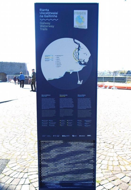
Galway Waterway Trails
⎯⎯⎯
Rianta Uiscebhealaí na Gaillimhe

Photographed by William Fischer, Jr., April 9, 2025
1. Galway Waterway Trails/Rianta Uiscebhealaí na Gaillimhe Marker Detail

River Trail
Although one of the shortest rivers in Europe at only 6km, the River Corrib is one of the fastest flowing. It is the heartbeat of Galway city, linking Lough Corrib to the wild Atlantic Ocean. Follow this trail to uncover some of its stories; from its bridges to the industries that used its strong current to create power, from some of the people associated with it, to the wide variety of wildlife that make the river their home.
Canal Trail
Opened in 1852, the Eglinton Canal was an important link to the sea, a fresh water supply and an industrial 'highway' for many businesses. While once it echoed to the sounds of barges and voices carrying passengers and goods, today it is an oasis of calm as it meanders through Galway. This trail will take you on a journey through the heritage of the city, where you'll encounter stories of daily life, industry and wildlife.
Coastal Trail
Galway city and port was, and still is, a gateway to the world and it developed as an important trading post on the edge of the Atlantic Ocean. The Coastal Trail will take you from the Claddagh, along Salthill
this page online
GALWAY
Since its foundation Galway has developed and flourished around its waterways. The waters that surround it are full of stories and experiences that reflect all the layers that make up this beautiful place. We hope you enjoy discovering our city.
The Fishmarket
This area is known locally as the Fishmarket. It was here that the women from the Claddagh area of the city, just across the river, sold their fish. Built around 1800, it replaced an older market on the town side of O'Brien's Bridge, which is further along the river. Once the site of Galway's medieval docks, it also became known as Spanish Parade, because of its location close tonish Arch.
The Origins of Galway
The origin of the name Galway, from the Irish word Gaillimh, is uncertain. Some say it comes from the Irish words 'gal and 'amh', which mean 'stony river, and the River Gaillimh was the original name

Photographed by William Fischer, Jr., April 7, 2025
2. Galway Waterway Trails/Rianta Uiscebhealaí na Gaillimhe Marker
Christopher Columbus
Before Christopher Columbus began his journey west across the Atlantic Ocean with the hope of finding a passage through to the Indies, records show that he visited Galway in 1477. During his stay he observed that he had found sure evidenge that 'men of Cathay [China] have come from the West', as he noted in his copy of Imago Mundi, one of the most important geographical works of the time.
Cé go bhfuil Abhainn na Gaillimhe i measc na n-aibhneacha is giorra de chuid na hEorpa, gan i a bheith ach 6km ar fad, tá sí i measc na n-aibhneacha is tapa i dtaca le luas sreabhaidh de. Tá sí i gcroilár chathair na Gaillimhe agus nascann si Loch Coirib leis an Aigéan Atlantach. Déan do bhealach trid an rian seo chun teacht ar chuid de na scéalta a bhaineann leis an gcathair, is é sin le rá, scéalta faoina droichid agus faoi na tionscail a d'úsáid
Photographed by William Fischer, Jr., April 9, 2025
3. Galway Waterway Trails/Rianta Uiscebhealaí na Gaillimhe Marker
Rian na Canála
Osclaíodh Canáil Eglinton sa bhliain 1852 agus ba nasc tábhachtach leis an bhfarraige i, b'ionann í agus soláthar fionnuisce agus ba 'bealach mór' tionscail í le haghaidh cuid mhór gnóthaí. Cé go mbíodh fuaim báirsí agus glórtha daoine a d'iompair paisinéirí agus earraí le cloisteáil uirthi tráth is ionann i, sa lá atá inniu ann, agus tearmann suaimhnis agus i ag fánaíocht trí Ghaillimh. Seolfaidh an rian seo thú arthuras tri oidhreacht na cathrach agus, le linn an turais sin, gheobhaidh tú spléachadh ar shaol laethúil, ar chúrsaí tionscail agus ar fhiadhúlra na cathrach.
Rian an Chósta
Bhí cathair agus calafort na Gaillimhe riamh, agus tá siad fós, ina dtairseach chuig an domhan mór agus tháinig siad chun bheith ina n-áit thábhachtach agus forbraíodh iad mar ionad tábhachtach trádála ar imeall an Aigéin Atlantaigh. Seolfaidh an Rian an Chósta thú ón gCladach, feadh Phromanáid Bhóthar na Trá, go dtí an Charraig Dhubh

Photographed by William Fischer, Jr., April 7, 2025
4. Galway Waterway Trails/Rianta Uiscebhealaí na Gaillimhe Marker
GAILLIMH
Ón tráth a bunaíodh Gaillimh, tá forbairt agus bisiú tagtha uirthi sa cheantar thart ar a cuid uiscebhealaí. Tá na huiscí a thimpeallaíonn í lán de scéalta agus d'eispéiris trína léirítear na sraitheanna go léir a bhaineann leis an ionad álainn seo. Tá súil againn go mbainfidh tú taitneamh as ár gcathair.
Margadh an Éisc
Tugtar margadh an éisc ar an gceantar seo go logánta. Is anseo ba ghnách le mná cheantar an Chladaigh sa chathair, go díreach trasna na habhann uaidh seo, a gcuid éisc a dhíol. Tógadh an margadh thart ar an mbliain 1800, agus ghlac sé ionad margadh níos sine ar thaobh an bhaile de Dhroichead Uí Bhriain atá suite in ionad níos falde ar aghaidh ar an abhainn. Ba é suíomh dhugaí meánaoiseacha na Gaillimhe é tráth agus, sa deireadh, tosaíodh ar Pharáid na Spáinneach a thabhairt air.
Luathstair na Gaillimhe
Nítear cinnte céard í bunbhrí ainm chathair na Gaillimhe. Deir roinnt daoine go mbaineann sé leis na focail 'gall' agus 'amh' a léiríonn 'abhainn charraigeach' agus gurbh é Abhainn na Gaillimhe an t-ainm a bhí ar an abhainn i dtosach. Tá daoine eile ann a mhaíonn go mbaineann an t-ainm le cúrsaí miotaseolalochta. De réir an traidisiúin, tugtar Gaillimh nó Galvia ar an gcathair ar bhonn ainm iníon an Ri mhiotasaigh Breasal. Deirtear gur bádh í san abhainn.
Críostóir Colambas
Sular chuir Críostóir Colambas tús lena thuras siar trasna an Aigéin Atlantaigh, agus é ag súil le teacht ar phasáiste chuig na hlndiacha, is léir, de réir na dtaifead atá ann, gur thug sé cuairt ar Ghaillimh

Photographed by William Fischer, Jr., April 7, 2025
5. Galway Waterway Trails/Rianta Uiscebhealaí na Gaillimhe Marker
Erected by Government of Ireland, Fáitle Ireland, Galway City Council, and Wild Atlantic Way.
Topics. This historical marker is listed in these topic lists: Industry & Commerce • Settlements & Settlers • Waterways & Vessels. A significant historical year for this entry is 1852.
Location. 53° 16.216′ N, 9° 3.268′ W. Marker is in Galway, Connacht, in County Galway. It is in the Latin Quarter. It can be reached from Spanish Arch. Marker is on the Spanish Parade plaza between the Wolfe Tone Bridge and the Spanish Arch. Touch for map. Marker is in this post office area: Galway, Connacht H91 P58E, Ireland. Touch for directions.

Regionally, it is on the Atlantic Ocean, in the North Atlantic Region, on the Atlantic Arc, in Europe, on the Island of Ireland, on the Celtic Fringe, in the European Union, in Atlantic Europe, on one of the British Isles, in the Western World, and in the Anglosphere.
Other nearby markers. At least 8 other markers are within walking distance of this marker: Spanish Arch/An Póirse Caoch (a few steps from this marker); In Memory of Mariners Lost at Sea / Captain William J. Woolley (within shouting distance of this marker); Cristoforo Colombo (within shouting distance of this marker); Seattle Stone (within shouting distance of this marker); Galway Democratic Republic (within shouting distance of this marker); Blake's Castle/
Credits. This page was last revised on December 3, 2025. It was originally submitted on April 20, 2025, by William Fischer, Jr. of Reynoldsburg, Ohio. This page has been viewed 281 times since then and 40 times this year. Photos: 1. submitted on April 20, 2025, by William Fischer, Jr. of Reynoldsburg, Ohio. 2. submitted on April 21, 2025, by William Fischer, Jr. of Reynoldsburg, Ohio. 3. submitted on April 20, 2025, by William Fischer, Jr. of Reynoldsburg, Ohio. 4, 5. submitted on April 21, 2025, by William Fischer, Jr. of Reynoldsburg, Ohio.
