Moab in Grand County, Utah — The American Mountains (Southwest)
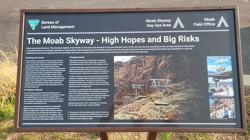
The Moab Skyway - High Hopes and Big Risks
Photographed by James Hulse, March 29, 2025
1. The Moab Skyway - High Hopes and Big Risks Marker
Realizing the Dream
Emmett Mays purchased this 160 acre parcel of land in 1973. Over the next 25 years, he and his oldest son Van secured the permits and investments needed to realize their ambitious dream: The Moab Skyway. Using a modified ski lift, the shuttle service would carry customers up the nearly 1,000 foot (300 meter) rim overlooking Moab Valley and Spanish Valley. Construction of the lift was completed within a year with the help of fellow family members Blake Atkins and Greg Nelson. Emmett and his family held the grand opening of The Moab Skyway in April 1999 to much excitement. The lift initially found success providing
this page online
No Expense Spared
One of the primary goals of the Moab Skyway was to provide opportunities for individuals of all abilities to enjoy the outstanding views from the rim of Moab Valley. It featured accessible ramps leading to the lift, a first-of-its-kind wheelchair accessible chair, and boardwalks leading to viewpoints overlooking the rim.
Safety and environmental assessments, including bird habitat surveys, noise pollution assessments for the adjacent neighborhood, vehicle fluid catchment systems for the parking lot, and relocating the chair lift to avoid overhead power lines, drove up costs. In addition, special earth tone striping was painted on the support structures and chairs to reduce their visual impact against the red rocks.
Changing Hands
Although the Skyway was a captivating and enjoyable experience for most visitors, ticket sales remained low. Some blamed the lift's fear factor for the lagging revenue.
In 2002, Emmett Mays sold the Moab Skyway and it was renamed the Moab Rim Adventure Park

Photographed by James Hulse, March 29, 2025
2. The Moab Skyway - High Hopes and Big Risks Marker
In 2005, The Nature Conservancy purchased the property. Volunteers rehabilitated the land and dismantled the chair lift and other structures. The chair lift was sold to the Whitefish Mountain Resort in Montana, where it continues to operate as the Easy Rider Quad and retains its earthtone striped paint from its Moab days.
The Bureau of Land Management purchased the property in December 2008 using The Land and Water Conservation Fund. The remaining buildings, now deteriorated, were removed, and the lower portion of the property refurbished and improved with shade structures, vault toilets, and informational signs for the public day use area.
Emmett passed away in 2011 at the age of 77, knowing that his "impossible dream" had been fulfilled.
Have you ever had an ambitious idea, dream, or business model? Were you able to do it? What lessons can we learn from the ever-changing landscape of both Moab and the businesses that occupy its valley?
Captions
(Photo #1) Two visitors riding the Skyway, April 1999.
(Photo #2) Emmett helps grand opening visitors, April 1999.
(Photo #3) Van and Emmett Mays, April 1999.
Erected by Bureau

Photographed by James Hulse, March 29, 2025
3. The view of the former Moab Skyway along the canyon wall
Topics. This historical marker is listed in these topic lists: Entertainment • Industry & Commerce • Parks & Recreational Areas. A significant historical month for this entry is April 1999.
Location. 38° 34.319′ N, 109° 34.263′ W. Marker is in Moab, Utah, in Grand County. It is on Kane Creek Boulevard half a mile east of 500 West, on the left when traveling west. The marker is located at a small BLM park at the parking lot. Touch for map. Marker is at or near this postal address: 934 Kane Creek Blvd, Moab UT 84532, United States of America. Touch for directions.

Regionally, this marker is in Canyon Country. It is also in the American Mountain West, on the Colorado Plateau, and at the Four Corners. Globally, it is in North America, the Western Hemisphere, the Western World, and the Anglosphere. Historically, it finds itself in what was once New Spain and also Mexico’s Alta California.

Other nearby markers. At least 8 other markers are within 2 miles of this marker, measured as the crow flies: Scott M. Matheson (about 400 feet away, measured in a direct line); Back of Beyond Books and Edward Abbey (approx. 1.1 miles away); Star Hall History (approx. 1.3 miles away); Star Hall (approx. 1.3 miles away); The Old Log Cabin (approx. 1.3 miles away); Moab L.D.S. Church (approx. 1.3 miles away); Early L.D.S. Church (approx. 1.3 miles away); Elk Mountain Mission (approx. 1.3 miles away). Touch for a list and map of all markers in Moab.
Credits. This page was last revised on April 24, 2025. It was originally submitted on April 24, 2025, by James Hulse of Medina, Texas. This page has been viewed 189 times since then and 43 times this year. Photos: 1, 2, 3. submitted on April 24, 2025, by James Hulse of Medina, Texas.
