Cong in County Mayo, Connacht, Ireland — Irish West ((Éire) North Atlantic Ocean)
The Guinness Tower
⎯⎯⎯
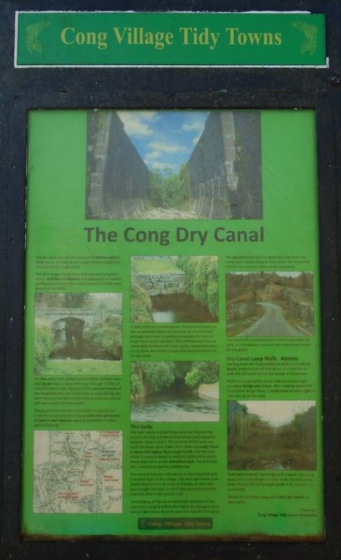
The Cong Dry Canal

Photographed by William Fischer, Jr., April 8, 2025
1. The Guinness Tower Marker
(or locally known as Leonard's Tower and also the Keeper's Tower)
Built in 1864 by Benjamin Lee Guinness
It was built in 1864 by Benjamin Lee Guinness so he could view all of his estate for the top of the tower.
There was once great views from the tower, Lough Corrib[,] Lough Mask and the Partry Mountains.
Today with some of the trees over 60 feet tall they now reach higher than the tower itself.
Apart from it's usefulness as a viewing tower for Ashford Castle's gamekeeper, it is nothing more than a rich man's folly, but the stonework is incredibly good.
The tower is unusual in that there is practically nothing inside except a stone spiral stairway and small octagonal room below the roof. There are 83 steps in the spiral stairway up to the rooftop of Cong woods.
How to get to the Guinness Tower
Firstly, walk through the Abbey grounds to the Monk's Fishing House and across the big Abbey bridge.
Next, cross over the big Abbey bridge and turn left and walk the path down along the river bank.
When you reach an old irongate, turn right and walk up path until you reach a large green gate on your left.
Continue straight on past this green gate on your left and follow walkway in to the wood.
You will after 5 minutes walking pass Teach Aille Cave on your right. Keep walking straight and follow pathway.
The pathway soon starts to turn right, at this point you will see a small path on your left leading to the Guinness Tower. Remember to mind the little children on the stairway up and also to leave no litter in our woods or on your walk.
Leave no Trace, Thank you.
The dry canal was started as a work of famine relief in 1848 and its aim was to link Lough Mask to Lough Corrib (and also to Lough Carra).
The scheme was to combine drainage and
this page online
For five years both skilled and unskilled workers were paid 4p per day to blast their way through 4 miles of solid limestone rock. Because of the porous nature of the limestone this was to become an engineering disaster because the bed of the canal proved too porous and was unable to retain water.
The government would not provide money to concrete the canal as by this time canals were going out of fashion and railways were in operation in many parts of Ireland.
In April 1854 the commissioners directed that work on the navigational aspect of the canal be discontinued; drainage work was to continue to enable the level of [L]ough [M]ask to be regulated. This artificial waterway so elaborately finished with sluice-gates, substantial locks of cut stone and arched bridges has become known as the dry canal.
The locks
The main works include three locks[,] two stone bridges (one at Cong and one at Drumsheel) and aqueduct between locks 2 and 3. The purpose of the locks was to lift the boats up
Photographed by William Fischer, Jr., April 8, 2025
2. The Cong Dry Canal Marker
The second lock was referred to as the Cong lock and is located right in the village. This lock was never completed and there is no trace of it today as Lord Ardilaun bought the land in 1876 and closed the section from the first to the second lock.
The building of the canal meant the direction of the road from Cong to Ballinrobe had to be changed and a new bridge had to be built over this road for the canal.
The aqueduct was built to allow the river from the rising water below Cong to flow under the new canal. This [is] all that remains today of the aqueduct.
The third lock is located close to the Cong public car park, on the Galway road and was completed except for the gates.
Dry Canal Loop Walk. 40mins
Starting from the Cong public car park, and walking North, down to the old lock gates, it is possible to walk the old canal bed to the bridge at Drumsheel.
Walk the length of the canal until you reach large cut stone bridge over head. After walking under the Drumsheel bridge there is stone steps on your right to take you up to the road.
Turn back towards the bridge and cross it, returning back in to Cong village in a loop walk. You will arrive down School Hill to the duck pond at O'Connor's supermarket.
Please do not litter Cong and LEAVE NO TRACE on your walks.
Erected by Cong Tidy Towns Committee and Cong Fóroige Youth Group.
Topics. This historical marker is listed in these topic lists: Architecture • Charity & Public Work • Settlements & Settlers • Waterways & Vessels. A significant historical month for this entry is April 1854.
Location. 53° 32.433′ N, 9° 17.219′ W.

Photographed by William Fischer, Jr., April 8, 2025
3. The Guinness Tower / The Cong Dry Canal Marker

Regionally, it is on the Atlantic Ocean, in the North Atlantic Region, on the Atlantic Arc, in Europe, on the Island of Ireland, on the Celtic Fringe, in the European Union, in Atlantic Europe, on one of the British Isles, in the Western World, and in the Anglosphere.
Other nearby markers. At least 8 other markers are within walking distance of this marker: The Quiet Man (a few steps from this marker); Cong Hands of Fame Award (a few steps from this marker); Proclamation of the Irish Republic (a few steps from this marker); Cong Abbey/
Credits. This page was last revised on December 3, 2025. It was originally submitted on April 24, 2025, by William Fischer, Jr. of Reynoldsburg, Ohio. This page has been viewed 204 times since then and 51 times this year. Photos: 1, 2, 3. submitted on April 24, 2025, by William Fischer, Jr. of Reynoldsburg, Ohio.
