
Richmond on Staten Island in Richmond County, New York — The American Northeast (Mid-Atlantic)
Where Does Your Grain Go?
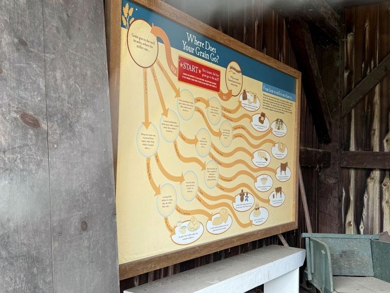
From farm to mill to merchant to…
wheat grown by Staten Island farmers was processed in Mills in a variety of ways. By adjusting the space between the millstones, the same sack of wheat could be ground into white flour, whole wheat flour, cracked wheat and more. The varieties of flour were sold to Staten Islanders or sent to Manhattan and New Jersey markets. There, the flour was bought by residents or shipped to international destinations.
★ Start ★
Hey farmer, did that grain go to the mill?
Choose an answer to each question. Follow your answers to see where flour from Staten Island might have ended up.
No: What a waste! Unused grain becomes worm food.
Yes: Grain goes to the mill in sacks, where the miller can…
Grind it: Finely grinding the whole grain makes whole-wheat flour, which travels aboard a…
Sloop: Made for sailing short distances quickly, the sloop crosses…Crack It: Coarsely grinding the whole grain makes cracked wheat flour, which is hauled by…
Kill Van Kull: A shoemaker in Elizabeth, NJ trades a leather apron for a month's supply of flour.Sailing Ship: From Peck's Slip near South Street,
New York Harbor: A Manhattan dockworker brings a roll for midday meal.the flour barrel travels…
Click or scan to see
this page online
South to the Caribbean: An English plantation owner in Jamaica gives rations to his slaves.
East to Europe: A Paris-bound sailing crew on a hard tack meal.
Oxcart: Leaving Richmond, the oxcart turns left at…Grind and sift it: Sifting two parts out of ground flour makes white flour, which is loaded onto a…
The Amboy Road: Just a mile away, a local farmer feeds slop to his pigs.Steam Ferry: Across the harbor, the flour is unloaded at Manhattan's Whitehall Ferry Landing and takes…
The King's Highway: On the long trip to Tompkinville Ferry Landing the driver feeds his oxen.
to Lower Manhattan: At the grocery, immigrants trade the flour to make porridge.
Uptown: North of the city, a farmer buys food at the store for his dairy cattle.
Train: From the closest station the new S.I.R.R. Co. tracks go…
North: A wealthy Clifton Heights family buys flour from the grocer to bake Christmas treats.Sailing Ship: Leaving Perth Amboy in a large ship, the white flour sails…
South: A child in Tottenville eats a very special birthday cake.
South to Charleston: A South Carolina plantation owner saves white flour for his own family.
East to Europe: An upper class London couple eats crumpets at high tea.
Erected by New York State Council on the Arts.
Topics. This historical marker is listed in these topic lists: Agriculture • Industry & Commerce.
Location. 40° 34.337′ N, 74° 8.788′ W. Marker is on Staten Island, New York, in Richmond County. It is in Richmond. It is at the intersection of Richmond Road and Richmond Hill Road, on the right when traveling west on Richmond Road. Touch for map. Marker is at or near this postal address: 3747 Richmond Rd, Staten Island NY 10306, United States of America. Touch for directions.

Regionally, this marker is in New York City. It is also in the American Northeast, in the Mid-Atlantic, and on the Eastern Seaboard. Globally, it is in the North Atlantic Region, North America, the Western Hemisphere, the Western World, and the Anglosphere. Historically, it finds itself in what was once New Netherland and also one of the original Thirteen Colonies.
Other nearby markers. At least 8 other markers are within walking distance of this marker: "Grist" for the Mills (here, next to this marker); Mills of Staten Island: Making Use of Natural Resources (here, next to this marker); Staten Island Connections (a few steps from this marker); Site of the Lighthouse Restaurant (within shouting distance of this marker); Site of 18th century structures (within shouting distance of this marker); Site of Richmond County Hall and the Parish House of St. Andrew's Church (within shouting distance of this marker); St. Andrew’s Church (within shouting distance of this marker); Treasure House (within shouting distance of this marker). Touch for a list and map of all markers in Staten Island.
Credits. This page was last revised on April 26, 2025. It was originally submitted on April 26, 2025, by Devry Becker Jones of Washington, District of Columbia. This page has been viewed 122 times since then and 24 times this year. Photo 1. submitted on April 26, 2025, by Devry Becker Jones of Washington, District of Columbia.
