Near Powhatan in Powhatan County, Virginia — The American South (Mid-Atlantic)
Lee’s Last Bivouac
April 14, 1865
Photographed by Bernard Fisher, April 26, 2009
1. Lee’s Last Bivouac CWT Marker
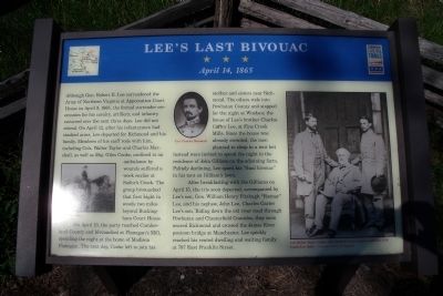
On April 13, the party reached Cumberland County and bivouacked at Flanagan’s Mill, spending the night at the home of Madison Flanagan. The next day, Cooke left to join his mother and sisters near Richmond. The others rode into Powhatan County and stopped for the night at Windsor, the house of Lee’s brother Charles Carter Lee, at Fine Creek Mills. Since the house was already crowded, the men planned to sleep in a tent but instead were invited to spend the night in the residence of John Gilliam on the adjoining
this page online
After breakfasting with the Gilliams on April 15, the trio soon departed, accompanied by Lee’s son, Gen. William Henry Fitzhugh “Rooney” Lee, and his nephew, John Lee, Charles Carter Lee’s son. Riding down the old river road through Powhatan and Chesterfield Counties, they soon neared Richmond and crossed the James River pontoon bridge at Manchester. Lee quickly reached his rented dwelling and waiting family at 707 East Franklin Street.
(captions)
Lee on Traveller
Col. Charles Marshall
Col. Walter Taylor (right), Gen. Robert E. Lee (center), and Gen. G.W. Custis Lee (left). - Courtesy Library of Congress
Erected by Virginia Civil War Trails.
Topics and series. This historical marker is listed in this topic list: War, US Civil. In addition, it is included in the Virginia Civil War Trails series list. A significant historical date for this entry is April 13, 1862.
Location. This marker has been replaced by another marker nearby. It was located near 37° 36.079′ N, 77° 49.686′ W. Marker was near Powhatan, Virginia, in Powhatan County. It was on Huguenot
Photographed by Bernard Fisher, April 26, 2009
2. Lee’s Last Bivouac CWT Marker

Regionally, this marker was in Virginia’s Piedmont, in Central Virginia, and in the Richmond Metropolitan Area. It was also in the American South and specifically in the Upper South. Globally, it was in North America, the Western Hemisphere, the Western World, and the Anglosphere. Historically, it found itself in what was once the territory of the Mississippian Culture, one of the original Thirteen Colonies, one of the Confederate States of America, and the Antebellum South.
Other nearby markers. At least 8 other markers are within 4 miles of this location, measured as the crow flies: Lee's Last Camp (here, next to this marker); a different marker also named Lee's Last Camp (here, next to this marker); Lee's Final Bivouac (a few steps from this marker); Shiloh Baptist Church (approx. 2.6 miles away); James Pleasants (approx. 2.7 miles away); The 1936 Virginia Prison Recordings (approx. 3.3 miles away); Dahlgren's Raid (approx. 3½ miles away); Tanglewood Ordinary (approx. 3.7 miles away). Touch for a list and map of all markers in Powhatan.
Related marker. Click here for another marker that is related to this marker. New Replacement CWT Marker At This Location titled "Lee's Last Camp"
Credits. This page was last revised on April 30, 2025. It was originally submitted on April 27, 2009, by Bernard Fisher of Richmond, Virginia. This page has been viewed 3,991 times since then and 176 times this year. Last updated on April 28, 2025, by Mike McKeown of Baltimore, Maryland. Photos: 1, 2. submitted on April 27, 2009, by Bernard Fisher of Richmond, Virginia.
