Penn Township near Jeannette in Westmoreland County, Pennsylvania — The American Northeast (Mid-Atlantic)
Rescue
Bushy Run Battlefield
Photographed by Bradley Owen, April 9, 2025
1. Rescue Marker
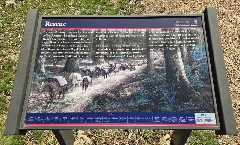
As news of the uprising reached General Jeffrey Amherst, he ordered Colonel Henry Bouquet to Fort Pitt to lift the siege. Bouquet's force consisted of men from the 42nd and 77th Highlanders, 60th Royal Americans, Royal Artillery gunners, and frontiersmen. In addition to the approximately 500 soldiers, his expedition included 50 civilians to move 60,000 pounds of flour, 100 cattle, and 200 sheep.
The condition of the British troops, the weather, bad road conditions, and movement of the livestock all worked to slow the relief army. At Fort Ligonier, Bouquet decided to leave his wagons and livestock and use 340 pack horses to transport provisions. His plan was to march to Bushy Run Station, rest the troops and then set out for Fort Pitt under cover of night.
(Timeline at the bottom of the marker)
• May 16 Fort Sandusky falls
• May 25 Fort St. Joseph falls
• May 27 Fort Miami falls
• May 29 Siege of Fort Pitt
• June 1 Fort Ouiatenon falls
• June 2 Fort Michilimackinac falls
• June 2 Fort Ligonier attacked
• June 4 Fort Pitt’s help request reaches Col. Bouquet
• June 12 Amhearst orders the 42nd and 77th to Bouquet
• June 16 Fort Venango falls
• June 18 Fort Le Boeuf falls
• June 22 Fort Pesque Isle falls
• July 15 Bouquet leaves Carlisle
• July 25 Bouquet arrives at Fort Bedford
• August 2 Bouquet arrives at Fort Ligonier
• August 4 Bouquet leaves Fort Ligonier
• August 5 Natives attack Bouquet relief forces
• August 6 British defeat the Natives at Bushy Run
• August 10 British arrive at Fort Pitt
• October 25 Natives sign treaty and release their British prisoners
Topics.
this page online
Location. 40° 21.343′ N, 79° 37.277′ W. Marker is near Jeannette, Pennsylvania, in Westmoreland County. It is in Penn Township. It can be reached from Bushy Run Road (Pennsylvania Route 993) 0.6 miles east of Gongaware Road, on the left when traveling east. Marker is located on the grounds of the Bushy Run Battlefield. Touch for map. Marker is at or near this postal address: 1253 Bushy Run Road, Jeannette PA 15644, United States of America. Touch for directions.

Regionally, this marker is in the Laurel Highlands and in Greater Pittsburgh. It is also in the American Northeast, in the Mid-Atlantic, in Appalachia, and specifically in Northern Appalachia. Globally, it is in North America, the Western Hemisphere, the Western World, and the Anglosphere. Historically, it finds itself in what was once the Viceroyalty of New France, the Haudenosaunee (Iroquois) Confederacy, and one of the original Thirteen Colonies.
Other nearby markers. At least 8 other markers are within walking distance of this marker: Flour Bag Fort
Photographed by Bradley Owen, April 9, 2025
2. Rescue Marker
Credits. This page was last revised on May 2, 2025. It was originally submitted on May 2, 2025, by Bradley Owen of Morgantown, West Virginia. This page has been viewed 120 times since then and 24 times this year. Photos: 1, 2. submitted on May 2, 2025, by Bradley Owen of Morgantown, West Virginia.
