Penn Township near Jeannette in Westmoreland County, Pennsylvania — The American Northeast (Mid-Atlantic)
The Central Fire
Bushy Run Battlefield
Photographed by Bradley Owen, April 9, 2025
1. The Central Fire Marker
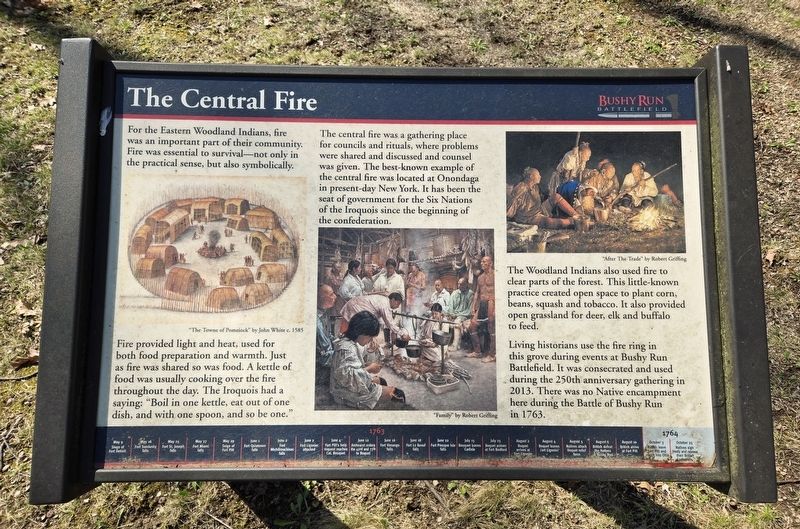
For the Eastern Woodland Indians, fire was an important part of their community. Fire was essential to survival-not only in the practical sense, but also symbolicaIlly. Fire provided light and heat, used for both food preparation and warmth. Just as fire was shared so was food. A kettle of food was usually cooking over the fire throughout the day. The Iroquois had a saying: "Boil in one kettle, eat out of one dish, and with one spoon, and so be one." The central fire was a gathering place for councils and rituals, where problems were shared and discussed and counsel was given. The best-known example of the central fire was located at Onondaga in present-day New York. It has been the seat of government for the Six Nations of the Iroquois since the beginning of the confederation.
The Woodland Indians also used fire to clear parts of the forest. This little-known practice created open space to plant corn, beans, squash and tobacco. It also provided open grassland for deer, elk and buffalo to feed.
Living historians use the fire ring in this grove during events at Bushy Run Battlefield. It was consecrated and used during
this page online
(Captions):
"The Towne of Pomeiock" by John White c. 1585
"Family" by Robert Griffing
"After The Trade" by Robert Griffing
(Timeline at the bottom of the marker)
• May 16 Fort Sandusky falls
• May 25 Fort St. Joseph falls
• May 27 Fort Miami falls
• May 29 Siege of Fort Pitt
• June 1 Fort Ouiatenon falls
• June 2 Fort Michilimackinac falls
• June 2 Fort Ligonier attacked
• June 4 Fort Pitt’s help request reaches Col. Bouquet
• June 12 Amhearst orders the 42nd and 77th to Bouquet
• June 16 Fort Venango falls
• June 18 Fort Le Boeuf falls
• June 22 Fort Pesque Isle falls
• July 15 Bouquet leaves Carlisle
• July 25 Bouquet arrives at Fort Bedford
• August 2 Bouquet arrives at Fort Ligonier
• August 4 Bouquet leaves Fort Ligonier
• August 5 Natives attack Bouquet relief forces
• August 6 British defeat the Natives at Bushy Run
• August 10 British arrive at Fort Pitt
• October 25 Natives sign treaty and release their British prisoners
Topics.
Photographed by Bradley Owen
2. The Central Fire Marker
Location. 40° 21.527′ N, 79° 37.542′ W. Marker is near Jeannette, Pennsylvania, in Westmoreland County. It is in Penn Township. It can be reached from Bushy Run Road (Pennsylvania Route 993) 0.6 miles east of Gongaware Road, on the left when traveling east. Marker is located on the grounds of Bushy Run Battlefield. Touch for map. Marker is at or near this postal address: 1253 Bushy Run Road, Jeannette PA 15644, United States of America. Touch for directions.

Regionally, this marker is in the Laurel Highlands and in Greater Pittsburgh. It is also in the American Northeast, in the Mid-Atlantic, in Appalachia, and specifically in Northern Appalachia. Globally, it is in North America, the Western Hemisphere, the Western World, and the Anglosphere. Historically, it finds itself in what was once the Viceroyalty of New France, the Haudenosaunee (Iroquois) Confederacy, and one of the original Thirteen Colonies.
Other nearby markers. At least 8 other markers are within walking distance of this marker: C. Martin Bomberger (within shouting distance of this marker); Pontiac's War (within shouting distance of this marker); The Iroquois Nature Trail (within shouting distance of this marker); Andrew Byerly's Spring (about 300 feet away, measured in a direct line); Welcome to Bushy Run Battlefield (about 600 feet away); Ambushed (approx. 0.2 miles away); After The Battle (approx. 0.2 miles away); Bushy Run Battle 250th Anniversary Monument (approx. 0.2 miles away). Touch for a list and map of all markers in Jeannette.
Credits. This page was last revised on May 3, 2025. It was originally submitted on May 3, 2025, by Bradley Owen of Morgantown, West Virginia. This page has been viewed 117 times since then and 15 times this year. Photos: 1, 2. submitted on May 3, 2025, by Bradley Owen of Morgantown, West Virginia.
