Fort Howard in Edgemere in Baltimore County, Maryland — The American Northeast (Mid-Atlantic)
Fort Howard
"The Bulldog at Baltimore's Gate"
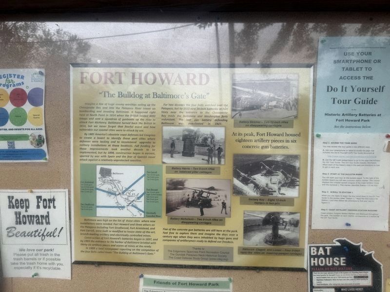
Imagine a line of huge enemy warships sailing up the Chesapeake Bay and into the Patapsco River intent on bombarding and invading Baltimore. It happened right here at North Point in 1814 when the British landed 4000 troops and sent a squadron of gunboats up the river to attack Fort McHenry. Baltimore turned back the British in 1814, but we never forgot that fearful event and how vulnerable our coastal cities were to attack by sea.
By 1885 America's obsolete coast defenses led Congress to create a board to identify those port cities where defenses were lacking and to recommend upgrades to military installations at those locations. Full funding for those improvements took another decade to be implemented, but by 1898, construction began in earnest, spurred by war with Spain and the fear of Spanish naval attack against a relatively unprotected coastline.
Baltimore was high on the list of those cities where new installations were needed. Fort Howard and three others on the Patapsco including Fort Smallwood, Fort Armistead, and Fort Carroll, were built or modified to house state-of-the-art, breech-loading artillery and
this page online
Construction of Fort Howard's batteries began in 1897, ad by 1903 the entrance tot he harbor of Baltimore bristled with thirty-six artillery pieces and scores of mines at the ready.
In 1908 a local newspaper reporting on the completion of the four forts called "The Bulldog at Baltimore's Gate."
For two decades the four forts watched over the Patapsco, but by 1922 new 16-inch batteries at Fort Story near the entrance to the Chesapeake Bay made the Baltimore and Washington forts redundant. The last gun battery defending Baltimore was deactivated in 1927.
Five of the concrete gun batteries are still here at the park. Feel free to explore them and imagine the days over a century ago when they were inhabited by huge guns and companies of artillerymen ready to defend our freedom.
Erected by The Edgemere Sparrows Point Recreation Council; The Dundalk Patapsco Neck Historical Society; The Coast Defense Study Group.
Topics. This historical marker is listed in these topic lists: Forts and Castles • War of 1812 • War, Spanish-American • Waterways & Vessels. A significant historical year for this entry is 1814.
Location. 39° 11.888′ N,

Regionally, this marker is in the Baltimore Metro Region and in Central Maryland. It is also in the American Mid-Atlantic, in the Chesapeake Bay Region, and on the Eastern Seaboard. Globally, it is in the North Atlantic Region, North America, the Western Hemisphere, the Western World, and the Anglosphere. Historically, it finds itself in what was once one of the original Thirteen Colonies and also the Antebellum South.
Other nearby markers. At least 8 other markers are within walking distance of this marker: Life at Fort Howard 1898-1917 (about 300 feet away, measured in a direct line); Battery Key (about 300 feet away); Power House (about 400 feet away); Harbor Defense: Controlled Mines and the Mine Casemate (about 400 feet away); Fort Howard During World War I (about 400 feet away); Life at Fort Howard 1920-1940 - The 12th Infantry (about 500 feet away); Duc Huc (about 600 feet away); Searchlight Power House (about 600 feet away). Touch for a list and map of all markers in Edgemere.
Another marker is no longer nearby. Fort Howard (was within shouting distance of this marker but has been replaced with another marker now near it).
Related marker. Click here for another marker that is related to this marker. This marker has replaced the linked marker.
Credits. This page was last revised on May 4, 2025. It was originally submitted on May 4, 2025, by Devry Becker Jones of Washington, District of Columbia. This page has been viewed 138 times since then and 38 times this year. Photos: 1, 2. submitted on May 4, 2025, by Devry Becker Jones of Washington, District of Columbia.
