Appomattox in Appomattox County, Virginia — The American South (Mid-Atlantic)
Walker's Last Stand
Custer's Charges
Photographed by Bernard Fisher, June 26, 2015
1. Walker's Last Stand Marker
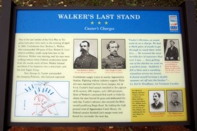
One of the last battles of the Civil War in Virginia took place here early in the evening of April 8, 1865. Confederate Gen. Reuben L. Walker, who commanded 100 guns of Gen. Robert E. Lee’s reserve artillery, made camp here late in the afternoon. Walker was shaving, and his men were cooking rations when Federal cavalrymen burst from the woods south of here. Walker formed one-third of his batteries into a semicircle, and his men began firing.
Gen. George A. Custer commanded the charging Federals, who had just captured Confederate supply trains at nearby Appomattox Station. Fighting without infantry support, Walker’s men repulsed the first three charges, but at 8 P.M. Custer’s final assault resulted in the capture of 25 cannon, 200 wagons, and 1,000 prisoners. Most of Walker’s command fled north to Oakville where the men buried 54 guns and disbanded the next day. Custer’s advance also secured the Richmond-Lynchburg Stage Road. By holding the high ground west of Appomattox Court House, the Federal cavalry blocked Lee’s escape route and forced his surrender the next day.
“Custer’s Division, as usual, went in on a charge. We had a thick piece of woods to get through to reach their Artillery. … We received the most terrible fire of cannister that ever I saw. … Soon getting out of the thicket we went on a perfect jump. Suddenly I felt a blow and a numbing sensation across my breast, & found myself turning a double summer set off into the bushes.”—Lt. Eri D. Woodbury, 1st Vermont Cavalry
Click or scan to see
this page online
(sidebar)
Pvt. Bernard Shields, 2nd West Virginia Cavalry, received the Medal of Honor for striking down Pvt. William Davis, 2nd Co., Washington Artillery of New Orleans, and capturing the battery's flag from Davis.
Pvt. Bernard Shields Courtesy John Elder Pvt. William Davis Courtesy Tulane University
Erected by Virginia Civil War Trails.
Topics and series. This historical marker is listed in this topic list: War, US Civil. In addition, it is included in the Virginia Civil War Trails series list. A significant historical date for this entry is April 8, 1865.
Location. 37° 21.914′ N, 78° 49.595′ W. Marker is in Appomattox, Virginia, in Appomattox County. It can be reached from the intersection of Jamerson Lane (Virginia Route 1014) and Jones Street ( Route 1012). Touch for map. Marker is in this post office area: Appomattox VA 24522, United States of America. Touch for directions.

Regionally, this marker is in the Piedmont and in Central Virginia. It is also in the American South and specifically in the Upper South. Globally, it is in North America, the Western Hemisphere, the Western
Photographed by Bernard Fisher
2. Battle of Appomattox Station CWT Markers
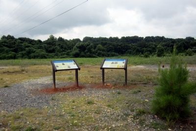
Other nearby markers. At least 8 other markers are within walking distance of this marker: Confederate Artillery Position (here, next to this marker); Battle of Appomattox Station (within shouting distance of this marker); Appomattox Campaign (within shouting distance of this marker); a different marker also named Battle of Appomattox Station (within shouting distance of this marker); Carver-Price School (approx. 0.4 miles away); Winonah Camp / Mozella Price Home (approx. 0.4 miles away); Heritage Garden (approx. 0.4 miles away); Fighting to the End (approx. 0.4 miles away). Touch for a list and map of all markers in Appomattox.
Other markers no longer nearby. Custer's Third Brigade (was within shouting distance of this marker but has been permanently removed); a different marker also named Winonah Camp / Mozella Price Home (was approx. 0.4 miles away but has been replaced with another marker now
Photographed by Bernard Fisher
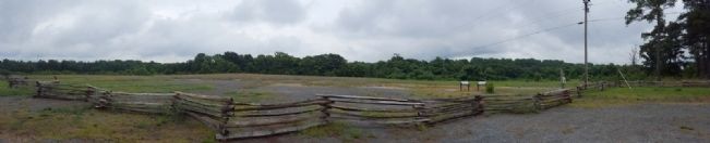
3. Battle of Appomattox Station Confederate Position
Also see . . . Appomattox Court House National Historical Park. (Submitted on June 27, 2015.)

June 26, 2015
4. Battle of Appomattox Station
Photographed by Bradley Owen, October 16, 2017
5. Welcome Sign To The Battlefield

Photographed by Evan Dwyer, December 13, 2025
6. Walker's Last Stand Marker
Marker has been mounted temporarily in the wooden interpretive kiosk on-site.
Credits. This page was last revised on January 16, 2026. It was originally submitted on June 27, 2015, by Bernard Fisher of Richmond, Virginia. This page has been viewed 1,532 times since then and 64 times this year. Last updated on May 5, 2025, by Mike McKeown of Baltimore, Maryland. Photos: 1, 2, 3, 4. submitted on June 27, 2015, by Bernard Fisher of Richmond, Virginia. 5. submitted on March 24, 2021, by Bradley Owen of Morgantown, West Virginia. 6. submitted on January 14, 2026, by Evan Dwyer of Richmond, Virginia. • Devry Becker Jones was the editor who published this page.
