
Fort Howard in Edgemere in Baltimore County, Maryland — The American Northeast (Mid-Atlantic)
Fort Howard During World War I
1917 - 1919
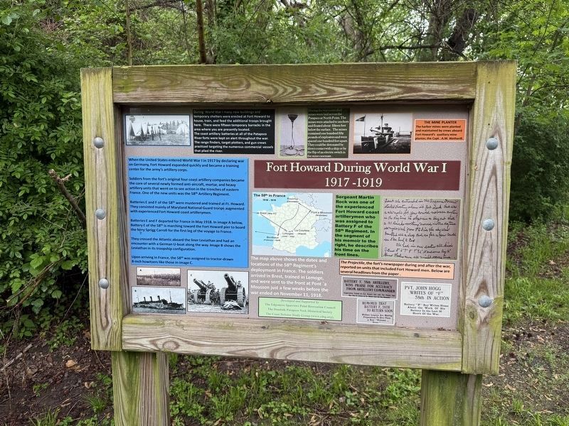
During World War I many new buildings and temporary shelters were erected at Fort Howard to house, train, and feed the additional troops brought here. There were fifteen temporary barracks in the area where you are presently located. The coast artillery batteries at all of the Patapsco River forts were kept on alert throughout the war. The range finders, target plotters, and gun crews practiced targeting the numerous commercial vessels that plied the river.
During the war controlled mines were laid across the Patapsco at North Point. The mines were attached to anchors and floated about fifteen feet below the surface. The mines contained one hundred fifty pounds of explosives and were spaced one hundred feet apart. They could be detonated by direct contact with a ship or by the flip of an electric switch in the mine casemate.
When the United States entered World War I in 1917 by declaring war on Germany, Fort Howard expanded quickly and became a training center for the
this page online
Soldiers from the fort's original four coast artillery companies became the core of several newly formed anti-aircraft, mortar, and heavy artillery units that went on to see action in the trenches of eastern France. One of the new units was the 58th Artillery Regiment.
Batteries E and F of the 58th were mustered and trained at Ft. Howard. They consisted mainly of Maryland National Guard troops augmented with experienced Fort Howard coast artillerymen.
Batteries E and F departed for France in May 1918. In image A below, Battery E of the 58th is marching toward the Fort Howard pier to board the ferry Sprigg Carroll for the first leg of the voyage to France.
They crossed the Atlantic aboard the liner Leviathan and had an encounter with a German U-boat along the way. Image B shows the Leviathan shows the Leviathan in its troopship configuration.
Upon arriving in France, the 58th was assigned to tractor-down 8-inch howitzers like those in image C.
The map above shows the dates and locations of the 58th Regiment's deployment in France. The soldiers arrived in Brest, trained in Lemoge, and were sent
Sergeant Martin Rock was one of the experienced Fort Howard coast artillerymen who was assigned to Battery F of the 58th Regiment. In the segment of his memoir to the right, he describes his time on the front lines.
The Projectile, the fort's newspaper during and after the war, reported on units that included Fort Howard men. Below are several headlines from the paper.
Erected by The Edgemere Sparrows Point Recreation Council; The Dundalk Patapsco Neck Historical Society; The Coast Defense Study Group.
Topics. This historical marker is listed in these topic lists: Education • Forts and Castles • War, World I • Waterways & Vessels. A significant historical month for this entry is May 1918.
Location. 39° 11.837′ N, 76° 26.541′ W. Marker is in Edgemere, Maryland, in Baltimore County. It is in Fort Howard. It is on Key Street near Fort Howard Park Road, on the right when traveling north. Touch for map. Marker is in this post office area: Fort Howard MD 21052, United States of America. Touch for directions.

Regionally, this marker is in the Baltimore Metro Region and in Central Maryland. It is also in the American Mid-Atlantic, in the Chesapeake Bay Region, and on the Eastern Seaboard. Globally, it is in the North Atlantic Region, North America, the Western Hemisphere, the Western World, and the Anglosphere. Historically, it finds itself in what was once one of the original Thirteen Colonies and also the Antebellum South.
Other nearby markers. At least 8 other markers are within walking distance of this marker: Life at Fort Howard 1920-1940 - The 12th Infantry (within shouting distance of this marker); Life at Fort Howard 1898-1917 (within shouting distance of this marker); Battery Key (within shouting distance of this marker); Artillery District of Baltimore 1899-1920 (about 300 feet away, measured in a direct line); Power House (about 300 feet away); Harbor Defense: Controlled Mines and the Mine Casemate (about 300 feet away); Battery Harris (about 300 feet away); This Maple (about 400 feet away). Touch for a list and map of all markers in Edgemere.
Another marker is no longer nearby. Fort Howard (was about 300 feet away but has been replaced with another marker now near it).
Credits. This page was last revised on May 5, 2025. It was originally submitted on May 5, 2025, by Devry Becker Jones of Washington, District of Columbia. This page has been viewed 208 times since then and 51 times this year. Photos: 1, 2. submitted on May 5, 2025, by Devry Becker Jones of Washington, District of Columbia.
