Schiller Park in Cook County, Illinois — The American Midwest (Great Lakes)
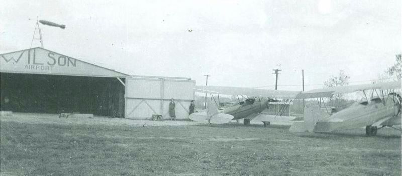
Former Site of Wilson Airport

Photographed by Sean P. Flynn, May 13, 2025
1. Former Site of Wilson Airport Marker
Erected by Schiller Park Historical Commission.
Topics. This historical marker is listed in these topic lists: Air & Space • Women. A significant historical year for this entry is 1922.
Location. 41° 57.946′ N, 87° 51.707′ W. Marker is in Schiller Park, Illinois, in Cook County. It is at the intersection of River Road (Illinois Route 171) and Lawrence Avenue on River Road. The marker is at the southwest corner of the intersection, next to the sign for the Shell gas station. Touch for map. Marker is at or near this postal address: 4758 River Road, Schiller Park IL 60176, United States of America. Touch for directions.

Regionally, this marker is in Greater Chicago. It is also in the American Midwest. Globally, it is in North America, on the Great Lakes, in the Western Hemisphere, in the Western World, and in the Anglosphere. Historically, it finds itself in what was once the Viceroyalty of New France, the territory of the Mississippian Culture, and the Northwest Territory.
this page online
Other nearby markers. At least 8 other markers are within walking distance of this marker: Henry Brockman’s Farm & Grist Mill (approx. ¼ mile away); Former Site of the Motykiewicz Farm (approx. half a mile away); Alexander Robinson (approx. ¾ mile away); Great Escape Restaurant Building (approx. ¾ mile away); Former Site of Soo Line Hotel (approx. 0.8 miles away); 9/11 Memorial (approx. 0.8 miles away); Horse-Shoe Inn (approx. 0.8 miles away); Schiller Park Military Service Wall of Honor (approx. 0.8 miles away). Touch for a list and map of all markers in Schiller Park.
Also see . . . Schiller Park Historic Sites map.
Excerpt: "From the 1930s to the mid-1940s, Wilson Airport occupied 37 acres of land at River Road and Lawrence Avenue. It was a popular place for wannabe pilots willing to work to pay for flying lessons. Mae Wilson was the flight instructor."(Submitted on May 13, 2025, by Sean P. Flynn of Oak Park, Illinois.)

Photographed by Sean P. Flynn, May 13, 2025
2. Former Site of Wilson Airport Marker

Photographed by Sean P. Flynn, May 13, 2025
3. River Road-Lawrence Avenue intersection
The back of the marker is visible near the intersection.
February 27, 2026
4. Wilson Airport when in operation.
Credits. This page was last revised on February 28, 2026. It was originally submitted on May 13, 2025, by Sean P. Flynn of Oak Park, Illinois. This page has been viewed 275 times since then and 86 times this year. Photos: 1, 2, 3. submitted on May 13, 2025, by Sean P. Flynn of Oak Park, Illinois. 4. submitted on February 27, 2026.
