
Near Columbia in Boone County, Missouri — The American Midwest (Upper Plains)
Roche Percée Natural Arch
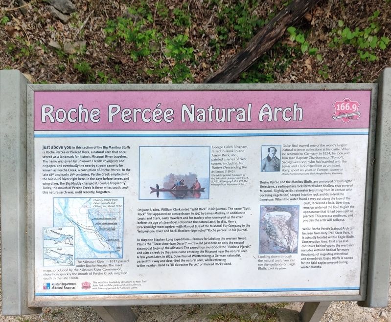
Photographed by John Ridley, April 27, 2023
1. Roche Percée Natural Arch Marker
Just above you in this section of the Big Manitou Bluffs is Roche Percée or Pierced Rock, a natural arch that once served as a landmark for historic Missouri River travelers. The name was given by unknown French voyageurs and engages, and eventually the nearby stream came to be known as Perche Creek, a corruption of Roche Percée. In the late 18th and early 19th centuries, Perche Creek emptied into the Missouri River right here. In the days before levees and wing dikes, the Big Muddy changed its course frequently. Today, the mouth of Perche Creek is three miles south, and this natural arch was, until recently, forgotten.
On June 6, 1804, William Clark noted "Split Rock" in his journal. The name "Split Rock" first appeared on a map drawn in 1797 by James Mackay. In addition to Lewis and Clark, early travelers and fur traders who journeyed up the river before the age of steamboats observed the natural arch. In 1811, Henry Brackenridge went upriver with Manuel Lisa of the Missouri Fur Company to the Yellowstone River and back. Brackenridge noted "Roche percée" in his journal.
In 1819, the Stephen Long expedition–famous
this page online
Roche Percée and the Manitou Bluffs are composed of Burlington limestone, a sedimentary rock formed when shallow seas covered Missouri. Slightly acidic rainwater (resulting from its contact with decaying vegetation) seeped into the rock and dissolved the limestone. When the water found a way out along the face of the bluff, it created a hole. Over time, erosion widened the hole to give the appearance that it had been split or pierced. This process continues, and one day the arch will collapse.
While Roche Percée Natural Arch can be seen from the Katy Trail State Park, it is actually located within Eagle Bluffs Conservation Area. That area also continues behind you to the west and includes wetland habitat for many thousands of migrating waterfowl and shorebirds. Eagle Bluffs is named for the bald eagles present during winter months.
Erected by Missouri Department of Natural Resources.
Topics. This historical marker is listed in these topic lists: Environment • Exploration • Settlements & Settlers. A significant historical date for this entry is June 6, 1804.
Location. 38° 53.249′ N, 92° 26.783′ W. Marker is near Columbia, Missouri, in Boone County. It can be reached from Katy Trail north of Perche Avenue (County Highway K), on the right when traveling north. Touch for map. Marker is at or near this postal address: 6347 Katy Trail, Columbia MO 65203, United States of America. Touch for directions.

Regionally, this marker is in Little Dixie and in the Missouri River Corridor. It is also in the American Midwest, in the Lewis & Clark Corridor, and in the Corn Belt. Globally, it is in North America, the Western Hemisphere, the Western World, and the Anglosphere. Historically, it finds itself in what was once the territory of the Mississippian Culture, the Louisiana Purchase, and the Antebellum South.
Other nearby markers. At least 8 other markers are within 8 miles of this marker, measured as the crow flies: The Lewis and Clark Expedition Across Missouri (here, next to this marker); McBaine to Rocheport (here, next to this marker); The Plank Road, Columbia-Providence (here, next to this marker); History of McBaine (here, next to this marker); a different marker also named The Lewis and Clark Expedition Across Missouri (approx. 4.9 miles away); Jewell Cemetery State Historic Site (approx. 6.3 miles away); Don Faurot / Faurot Field (approx. 7 miles away); Smithton - 1818 (approx. 7.1 miles away). Touch for a list and map of all markers in Columbia.
Another marker is no longer nearby. Jewell Cemetery (was approx. 6.3 miles away but has been replaced with another marker now near it).
Credits. This page was last revised on February 23, 2026. It was originally submitted on May 14, 2025, by John Ridley of Chelsea, Michigan. This page has been viewed 509 times since then and 122 times this year. Photo 1. submitted on May 14, 2025, by John Ridley of Chelsea, Michigan. • Devry Becker Jones was the editor who published this page.
Editor’s want-list for this marker. A wide shot of the marker in context. • Can you help?
