Canyon Rim in Millcreek in Salt Lake County, Utah — The American Mountains (Southwest)
The Golden Pass Road and Tollhouse
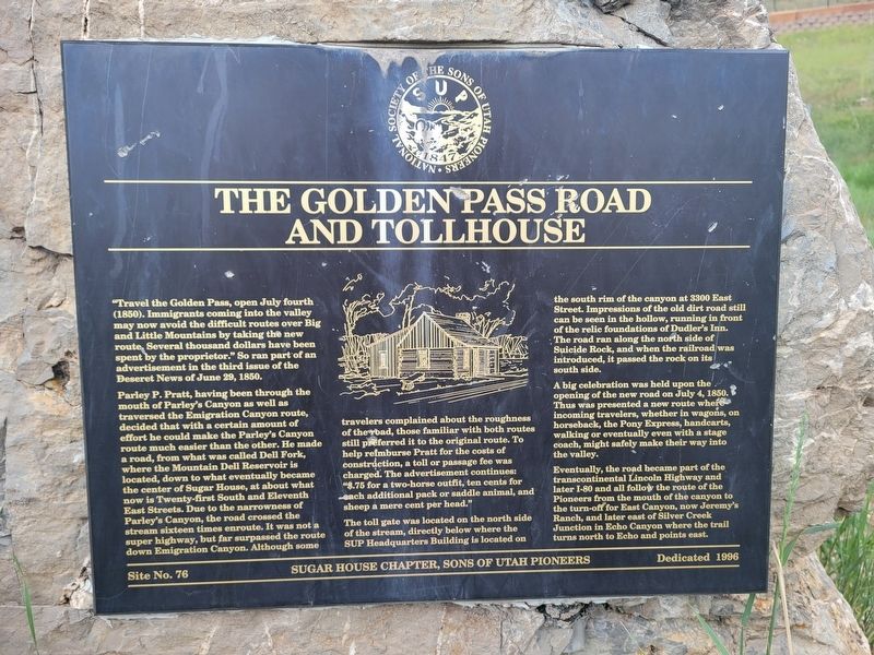
Photographed by Jeremy Snow, May 19, 2025
1. The Golden Pass Road and Tollhouse Marker
"Travel the Golden Pass, open July fourth (1850). Immigrants coming into the valley may now avoid the difficult routes over Big and Little Mountains by taking the new route. Several thousand dollars have been spent by the proprietor." So ran part of an advertisement in the third issue of the Deseret News of June 29, 1850.
Parley P. Pratt, having been through the mouth of Parley's Canyon as well as traversed the Emigration Canyon route, decided that with a certain amount of effort he could make the Parley's Canyon route much easier than the other. He made a road, from what was called Dell Fork, where the Mountain Dell Reservoir is located, down to what eventually became the center of Sugar House, at about what now is Twenty-first South and Eleventh East Streets. Due to the narrowness of Parley's Canyon, the road crossed the stream sixteen times enroute. It was not a super highway, but far surpassed the route down Emigration Canyon. Although some travelers complained about the roughness of the road, those familiar with both routes still preferred it to the original route. To help reimburse Pratt for the costs of
this page online
The toll gate was located on the north side of the stream, directly below where the SUP Headquarters Building is located on the south rim of the canyon at 3300 East Street. Impressions of the old dirt road still can be seen in the hollow, running in front of the relic foundations of Dudler's Inn. The road ran along the north side of Suicide Rock, and when the railroad was introduced, it passed the rock on its south side.
A big celebration was held upon the opening of the new road on July 4, 1850. Thus was presented a new route where incoming travelers, whether in wagons, on horseback, the Pony Express, handcarts, walking or eventually even with a stage coach, might safely make their way into the valley.
Eventually, the road became part of the transcontinental Lincoln Highway and later I-80 and all follow the route of the Pioneers from the mouth of the canyon to the turn-off for East Canyon, now Jeremy's Ranch, and later east of Silver

Photographed by Jeremy Snow, May 19, 2025
2. The Golden Pass Road and Tollhouse Marker
Erected 1996 by Sons of Utah PioneersSugar House Chapter. (Marker Number 76.)
Topics and series. This historical marker is listed in this topic list: Roads & Vehicles. In addition, it is included in the Sons of Utah Pioneers series list. A significant historical date for this entry is July 4, 1850.
Location. 40° 42.627′ N, 111° 48.193′ W. Marker is in Millcreek, Utah, in Salt Lake County. It is in Canyon Rim. It can be reached from Parley's Trail. Marker located along the trail in Parley's Historic Nature Park. Touch for map. Marker is at or near this postal address: Parley's Trail, Salt Lake City UT 84109, United States of America. Touch for directions.

Regionally, this marker is in the Wasatch Front and in Greater Salt Lake. It is also in the American Mountain West and on the Colorado Plateau. Globally, it is in North America, the Rocky Mountains, the Western Hemisphere, the Western World, and the Anglosphere. Historically, it finds itself in what was once New Spain and also Mexico’s Alta California.
Other nearby markers. At least 8 other markers are within 2 miles of this marker, measured as the crow flies: The Railroad (about 300 feet away, measured in a direct line); Dudler's Inn (about 800 feet away); Dudler's Wine Cellar (about 800 feet away); Sandstone Wall & Aquaduct (approx. 0.2 miles away); Early East Millcreek Schools (approx. 1.1 miles away); Pioneer Flour-Mill Site (approx. 1.1 miles away); Legacy of the Black Pioneer (approx. 1.6 miles away); Brigham Young Industrial Center (approx. 1.7 miles away).
Credits. This page was last revised on May 24, 2025. It was originally submitted on May 24, 2025, by Jeremy Snow of Cedar City, Utah. This page has been viewed 268 times since then and 59 times this year. Photos: 1, 2. submitted on May 24, 2025, by Jeremy Snow of Cedar City, Utah. • Andrew Ruppenstein was the editor who published this page.
