Totnes in Devon, England, United Kingdom — Northwestern Europe (the British Isles)
The Shady Garden
A peaceful place at the heart of town.
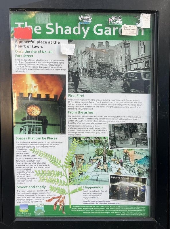
Photographed by Ray Gurganus, April 6, 2025
1. The Shady Garden Marker
Once the site of No. 49, Fore Street
Since mediaeval times a building stood on what is now the Shady Garden site. It was probably once the home of a wealthy merchant. We know its history from the 1870s, as a homeopathic dispensary, then a milliner and draper's, a sweet shop, and finally an antiques shop (photo, right).
Fire! Fire!
One winter's night in 1954 the ancient building caught fire, with flames leaping 50 feet above the roof. Totnes Fire Brigade turned out in just 3 minutes, and was helped by townsfolk and Torbay fire service. Luckily a strong wind had died down shortly before the fire started, and heroic firefighting prevented the blaze from spreading along Fore Street.
From the ashes
The shell of No. 49 had to be demolished. The following year another fire destroyed the Totnes Pannier Market building in 1990 the iconic East Gate was burnt down (photo, left). Such events have been common in ancient towns, the Great Fire of London being a famous example.
Totnes responded creatively to these challenges, establishing much-needed public spaces in Shady Garden and the Market Place restoring East Gate to its
this page online
Spaces that can be Places
The site became a public garden. It had various names but was often called the shady garden because of the large tree growing there. Despite several renovations, it eventually became down at heel and little used.
In 2011 a Totnes community forum set out to turn such spaces into enjoyable places for townsfolk and visitors. A Shady Garden community project was formed, which eventually came under the umbrella of Totnes Trust By 2015 a small yet inviting new piazza had been created for the town.
Sweet and shady
The Honey Locust tree at the heart of this garden originates as a species from the USA, it is named for the sweet taste of its seed pods, which were eaten by native American peoples and can be used to make a type of beer!
Topics. This historical marker is listed in these topic lists: Disasters • Parks & Recreational Areas.
Location. 50° 25.879′ N, 3° 41.146′ W. Marker is in Totnes, England, in Devon. It is on Fore Street, on the right when traveling west. Touch for map. Marker is at or near this postal address: 50B Fore St, Totnes, England TQ9 5RP, United Kingdom. Touch for directions.

Regionally, this marker is in South West England. Globally, it is on the Atlantic Ocean, in the North Atlantic Region, in Europe, in Atlantic Europe, on one of the British Isles, in the Western World, and in the Anglosphere. Historically, it finds itself in what was once the Roman Empire.
Other nearby markers. At least 8 other markers are within 10 kilometers of this marker, measured as the crow flies: Ann Ball (about 150 meters away, measured in a direct line); Totnes Town Mill (about 210 meters away); The Posts of the Town Marsh Gate (about 210 meters away); Welcome to The Market Square (approx. 0.3 kilometers away); The Medieval Town of Totnes (approx. 0.4 kilometers away); The Shell Keep (approx. 0.4 kilometers away); The Castle Bailey (approx. 0.4 kilometers away); Paignton: Episcopal Manor, Town and Palace (approx. 8.2 kilometers away). Touch for a list and map of all markers in Totnes.
Credits. This page was last revised on May 28, 2025. It was originally submitted on May 25, 2025, by Ray Gurganus of Washington, District of Columbia. This page has been viewed 100 times since then and 22 times this year. Photo 1. submitted on May 25, 2025, by Ray Gurganus of Washington, District of Columbia. • Andrew Ruppenstein was the editor who published this page.
Editor’s want-list for this marker. photo of the marker within its surroundings • Can you help?
