Delaware Airpark & Kenton Hundred near Cheswold in Kent County, Delaware — The American Northeast (Mid-Atlantic)
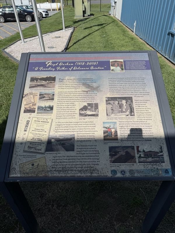
Floyd Durham (1918-2010)
"A Founding Father of Delaware Aviation"
"Floyd Durham has achieved in Delaware what is considered nearly impossible in the entire field of aviation. He built a privately-owned, public use airport, complete with hard-surface runway, taxiway and ramp, instrument approach, operations building, service hangar, storage hangar, and lighting entirely from personal family income, and he survived (to tell about it)."
George J. Frebert, Delaware Aviation History
Floyd H.L. Durham (1918-2010) created Delaware Airpark. A Lenape Indian, the middle child of seven, he was raised on a tenant farm east of Dover where he learned to be self-sufficient and independent. When a teenager, Floyd saw airplanes flying overhead and fell in love with the dream of owning and flying his own airplane.
Unable to pass the physical for the Civilian Pilot Training Programs (CPTP), Floyd learned instead the skills of plumbing, starting a business in a small building in the back yard of the Cheswold family home. In 1950, Floyd passed the civilian pilot physical and earned his pilot's license. Floyd's dream of lying was about to come true. He bought a hangar at the former Sunglo Airfield
this page online
In 1954, Hurricane Hazel damaged the Sunglo Airfield, collapsing the hangar on Floyd's plane, and permanently closing the airfield. Undaunted, Floyd moved his Ercoupe to his home garage for repairs. At about that time, some land became available adjoining Floyd's Cheswold property, and he purchased it with the intention of clearing the land and creating his own private airstrip.
Thus Delaware Airpark had its beginning as a place to support Floyd's love for flying his Ercoupe, but it evolved into much more. The 1,800-foot-long strip was expanded as time and personal funds permitted. Floyd did this while running a one-man plumbing operation, his sole means of income, and raising a family with his schoolteacher wife, Doris. Originally called "Little Acres," the field was private, government funds weren't available, and the Durhams did not have any wealthy family members or friends from whom to borrow.
As the airport developed,

Floyd's love of aviation and of the airfield was recognized in 1988 when he received the Air Force Assocaition's "Miss Mary Biggs Award for Excellence in Aviation Community Services." In 2000, recognizing Floyd as one of the "founding fathers of general aviation in Delaware," the Delaware Aviation Hall of Fame made him an inaugural inductee. That same year, Floyd retired when he sold the airfield to the state of Delaware. Floyd Durham passed away at age 92 in 2010. The Quiet Birdsmen and the Federal Aviation Administration honored him by recommending renaming Runway 9 Waypoint,

Photographed by Devry Becker Jones (CC0), May 24, 2025
3. Signage inside the building
Since 2004, the Delaware Airpark has been jointly administered by Delaware State University and the Delaware River and Bay Authority.
Erected by Delaware River and Bay Authority; U.S. Department of Transportation; Delaware State University; John Milner Associates, Inc.; Delaware Department of Transportation Cultural Resources.
Topics and series. This historical marker is listed in these topic lists: Air & Space • Indigenous Peoples and Communities • Industry & Commerce. In addition, it is included in the Historically Black Colleges and Universities series list. A significant historical year for this entry is 1950.
Location. 39° 13.056′ N, 75° 35.765′ W. Marker is near Cheswold, Delaware, in Kent County. It is in Delaware Airpark & Kenton Hundred. It is on Durham Lane north of 7 Hickories Road (Delaware Route 42), on the right when traveling north. Touch for map. Marker is at or near this postal address: 127 Durham Ln, Dover DE 19904, United States of America. Touch for directions.

Regionally, this marker is in the American Mid-Atlantic, on the Delmarva Peninsula, and on the Eastern Seaboard. Globally, it is in the North Atlantic Region, North America, the Western Hemisphere, the Western World, and the Anglosphere. Historically, it finds itself in what was once New Netherland, one of the original Thirteen Colonies, and the Antebellum South.
Other nearby markers. At least 8 other markers are within 3 miles of this marker, measured as the crow flies: Lenape Indian Tribe of Delaware (here, next to this marker); Kenton Hundred (approx. half a mile away); Little Creek Hundred (approx. 0.6 miles away); Cheswold Volunteer Fire Company (approx. 0.7 miles away); a different marker also named Little Creek Hundred (approx. 1.8 miles away); Fork Branch Nature Preserve (approx. 2.6 miles away); a different marker also named Fork Branch Nature Preserve (approx. 2.7 miles away); Welcome to Fork Branch Nature Preserve (approx. 2.9 miles away). Touch for a list and map of all markers in Cheswold.
Credits. This page was last revised on May 15, 2026. It was originally submitted on May 25, 2025, by Devry Becker Jones of Washington, District of Columbia. This page has been viewed 206 times since then and 48 times this year. Photos: 1, 2, 3. submitted on May 25, 2025, by Devry Becker Jones of Washington, District of Columbia.
