
Calstock in Cornwall, England, United Kingdom — Northwestern Europe (the British Isles)
Calstock Roman Fort
Photographed by Ray Gurganus, April 9, 2025
1. Calstock Roman Fort Marker
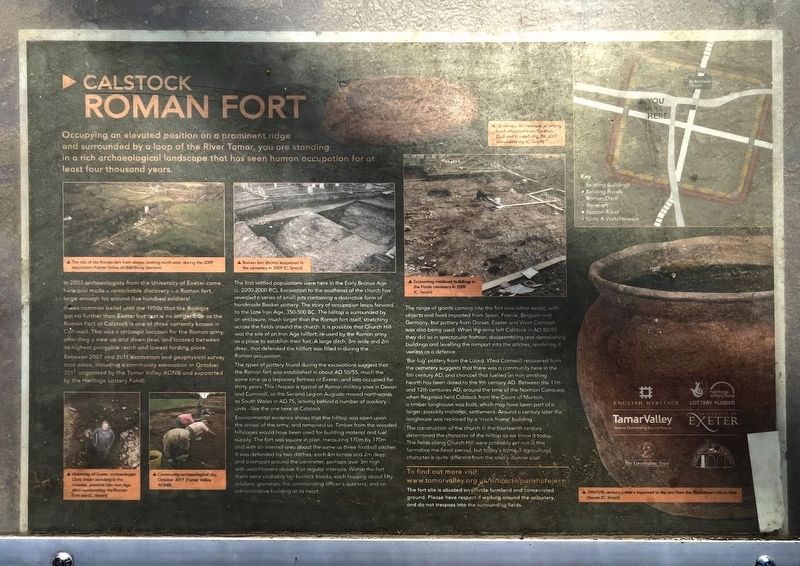
In 2007 archaeologists from the University of Exeter came here and made a remarkable discovery — a Roman fort, large enough for around five hundred soldiers! It was common belief until the 1950s that the Romans got no further than Exeter but that is no longer true as the Roman Fort at Calstock is one of three currently known in Cornwall. This was a strategic location for the Roman army, providing a view up and down river, and located between its highest navigable reach and lowest fording place. Between 2007 and 2011 excavation and geophysical survey took place, including a community excavation in October 2011 (organised by the Tamar Valley AONB and supported by the Heritage Lottery Fund).
The first settled populations were here in the Early Bronze Age (c 2200-2000 BC). Excavation to the southeast of the church has revealed a series of small pits containing a distinctive form of handmade Beaker pottery. The
this page online
The types of pottery found during the excavations suggest that the Roman fort was established in about AD 50/55, much the same time as a legionary fortress of Exeter, and was occupied for thirty years. This lifespan is typical of Roman military sites in Devon and Cornwall, as the Second Legion Augusta moved northwards to South Wales in AD 75, leaving behind a number of auxiliary units - like the one here of Calstock.
Environmental evidence shows that the hilltop was open upon the arrival of the army, and remained so. Timber from the wooded hillslopes would hove been used for building material and fuel supply. The fort was square in plan, measuring 170m by 170m and with on internal area about the some as three football pitches. It was defended by two ditches, each 4m across and 2m deep, and a rampart around the perimeter, perhaps over 3m high with watchtowers above it at regular intervals. Within The fort there were probably ten barrack blocks, each housing about fifty soldiers; granaries; the commanding officer's quarters, and on administrative building at its heart.
The range of goods coming into the fort was rather exotic, with objects and food imported from Spain, France, Belgium and Germany, but pottery from Dorset, Exeter and West Cornwall was also being used. When the army left Calstock in AD 80/85 they did so in spectacular fashion, disassembling and demolishing buildings and levelling the rampart into the ditches, rendering it useless as a defence.
'Bar-lug' pottery from the Lizard, West Cornwell recovered from the cemetery suggests that there was a community here in the 8th century AD, and charcoal that fuelled an iron-smithing hearth has been doted to the 9th century AD. Between the 11th and 12th centuries AD, around the time of the Norman Conquest, when Reginald held Calstock from the Count of Morton, a timber longhouse was built, which may hove been part of a larger, possibly manorial, settlement. Around a century later the longhouse was replaced by a 'cruck-frame' building.
The construction of the church in the fourteenth century determined the character of the hilltop as we know it today. The fields along Church Hill were probably set out in this formative medieval period, but today's tranquil agricultural character is quite different from the area's diverse past.
The fort site is situated on private farmland and consecrated ground. Please hove respect if walking around the cemetery, and do not trespass into the surrounding fields.
Erected by English Heritage.
Topics. This historical marker is listed in these topic lists: Anthropology & Archaeology • Forts and Castles.
Location. 50° 30.121′ N, 4° 12.434′ W. Marker is in Calstock, England, in Cornwall. It is on Glebelands. Touch for map. Marker is at or near this postal address: 3 Glebelands, Calstock, England PL18, United Kingdom. Touch for directions.

Regionally, this marker is in South West England. Globally, it is on the Atlantic Ocean, in the North Atlantic Region, on the Atlantic Arc, in Europe, on the Celtic Fringe, in Atlantic Europe, on one of the British Isles, in the Western World, and in the Anglosphere. Historically, it finds itself in what was once the Roman Empire.
Other nearby markers. At least 8 other markers are within 16 kilometers of this marker, measured as the crow flies: Accident at Bere Ferrers Station (approx. 6 kilometers away); Bere Ferrers War Memorial (approx. 6.2 kilometers away); Lower Lodge and Navy Memorials (approx. 14.5 kilometers away); Richard Dunning 1761-1851 (approx. 14.5 kilometers away); Stoke Damerel Parish Church (approx. 14.5 kilometers away); Those that Fell -- DHS in World War One (approx. 14.5 kilometers away); The Name "Briton Side" (approx. 15.5 kilometers away); Twinning of Plymouth and Donostia-San Sebastian (approx. 15.5 kilometers away).
Credits. This page was last revised on June 4, 2025. It was originally submitted on May 27, 2025, by Ray Gurganus of Washington, District of Columbia. This page has been viewed 117 times since then and 33 times this year. Photo 1. submitted on May 27, 2025, by Ray Gurganus of Washington, District of Columbia. • Andrew Ruppenstein was the editor who published this page.
Editor’s want-list for this marker. photo of the marker within its surroundings • Can you help?
