Mackinaw City in Cheboygan County, Michigan — The American Midwest (Great Lakes)
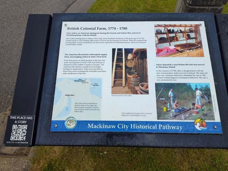
British Colonial Farm, 1774 - 1780
Mackinaw City Historical Pathway
Photographed by Craig Doda, May 25, 2025
1. British Colonial Farm, 1774 - 1780 Marker
John Askin, an American immigrant during the French and Indian War, arrived at Michilimackinac with the British.
John Askin immigrated to Albany, New York, from Northern Ireland in 1758 at the age of 19. He started work in a fur trading office and in 1763 set up his business in Detroit. There he acquired the paid position of post commissary for the newly captured Fort Michilimackinac where he amassed considerable wealth.
The American Revolution interrupted supply lines, encouraging Askin to start a local farm.
Food was grown in small gardens at the fort, but most was acquired in trade with local Indians or shipped in from eastern Canada or Europe. The American Revolution caused food shortages. Perhaps in desperation, Askin received title to about four acres of marginally farmable land three miles southwest of the fort.
Askin departed a year before the fort was moved to Mackinac Island.
In the summer of 1780, after a disagreement with the new commandant, Askin moved to Detroit. The farm fell into ruin. Amateur historians identified the site in 1981. A short archaeological investigation followed. The site is now protected
this page online
[Captions:]
John Askin lived occassionally at the farm based on the upper class dish remnants excavated. The farm was worked by Askin's servants and Indian slaves.
Food was stored in cool cellars.
A few exploratory trenches and a resistivity study led to a preliminary site plan.
Erected 2021.
Topics. This historical marker is listed in these topic lists: Colonial Era • Forts and Castles • Industry & Commerce. A significant historical year for this entry is 1758.
Location. 45° 46.907′ N, 84° 43.929′ W. Marker is in Mackinaw City, Michigan, in Cheboygan County. It is at the intersection of East Central Street and North Nicolet Street, on the right when traveling west on East Central Street. Touch for map. Marker is at or near this postal address: 106 N Nicolet St, Mackinaw City MI 49701, United States of America. Touch for directions.

Regionally, this marker is in Northern Michigan Lower Peninsula, on the Straits of Mackinac, and in one of the Lake Huron Shore counties. It is also in the American Midwest. Globally, it is in North America, in the Great North Woods, on the Great Lakes, in the Western

Photographed by Craig Doda, May 25, 2025
2. British Colonial Farm, 1774 - 1780 Marker
Other nearby markers. At least 8 other markers are within walking distance of this marker: Indians at the Straits (within shouting distance of this marker); French House Ruin, 1765 - 1781 (about 400 feet away, measured in a direct line); a different marker also named French House Ruin (about 400 feet away); Hattie Stimpson 1875-1948 (about 500 feet away); Tourism at Mackinac (about 600 feet away); Missionaries at Mackinac (about 600 feet away); The Barnett Building (approx. 0.2 miles away); The Courageous Members of Organized Labor (approx. 0.2 miles away). Touch for a list and map of all markers in Mackinaw City.
Other markers no longer nearby. British Colonial Farm 1774 - 1780 (was a few steps from this marker but has been replaced with another marker now near it); a different marker also named Tourism at Mackinac (was about 600 feet away but has been permanently removed).
Credits. This page was last revised on May 29, 2025. It was originally submitted on May 29, 2025, by Craig Doda of Napoleon, Ohio. This page has been viewed 173 times since then and 28 times this year. Photos: 1, 2. submitted on May 29, 2025, by Craig Doda of Napoleon, Ohio. • Devry Becker Jones was the editor who published this page.
