Parowan in Iron County, Utah — The American Mountains (Southwest)
Old Spanish National Historic Trail
Photographed by Jeremy Snow, May 31, 2025
1. Old Spanish National Historic Trail Marker
...the longest, crookedost, most arduous pack mule route in the history of America...
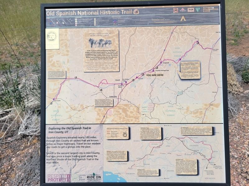
Profit could be made transporting New Mexico serapes and other woolen goods to Los Angeles, and wrangling California-bred horses and mules back to Santa Fe. A viable overland route across the remote deserts and mountains of what was then Mexico's far northern frontier had to be found.
It took the vision and courage of Mexican trader Antonio Armijo to lead the first successful commercial caravan in 1829. Following a combination of indigenous footpaths, and early trade and exploration routes, he forged a trail network that collectively became known as the Old Spanish Trail (OST).
Traveling east back from California in 1844 John C. Fremont followed the OST all the way to the Parowan Valley before deviating from it. His maps and diaries of the western section of the OST guided the Mormon Settlers who heavily developed the trail into a path passable by wagon all the way to Los Angeles in 1847.
One of the better documented trips along the OST is from Orville Pratt's expedition in 1848. He described his descent of Little Creek as
"up the steepest of hills, then down places it would seem almost impossible to descend, again in deep and precipitious canions.
However,
this page online
"suddenly broke upon us one the finest and most extensive valleys I have seen in the whole western country!"
Cedar City contains fantastic collections of artifacts and information from the period of the Old Spanah Trail's significance. Southern Utah University hosts the Palmer Western History Collection, and the Iron Mission State Historical Monument is also worth a visit and boasts over 100 horse drawn vehicles in its collection.
Exploring the Old Spanish Trail in Iron County, UT
Spanish Explorers traveled nearly 100 miles through Iron County on routes that are known today as major highways. Travel on our modern day roads to get a glimps into the past.
Enoch is the second largest city in Iron County, and was once a major trading post along the Northern Route of the Old Spanish Trail in the mid-1800s.
All Routes: came together at Fork of Roads, east of present-day Barstow in the Mojave desert, and then crossed Cajon Pass between the San Gabriel and San Bernadino Mountains to Coastal California. After negotiating the pass, traders had

Photographed by Jeremy Snow, May 31, 2025
2. Old Spanish National Historic Trail Marker
The Northern Route:
First blazed by William Wolfskill and George C. Yount in 1831, this route veered northwest from Abiquiú through southern Colorado and central Utah. It avoided the rugged canyons of the Colorado River that the Armijo party had encountered and took advantage of the better water and pastore resources across central Utah before returning to the Colorado River and Armijo's route not far from Las Vegas.
The Mojave Road:
A 188-mile crossing of the Mojave Desert long used by Indians and by Spanish explorers and missionaries, it was first traveled by Jedediah Smith, an American trapper in 1826.
The North Branch:
This route followed well-known trapper and trade routes north through the Rio Grande Gorge to Taos and into southern Colorado. It then went west through Cochetona Pass, largely open during the winter when other passes were snowed in and up the Gunnison River Valley, rejoining the Northern Route near present-day Green River, Utah.
The Armijo Route:
The first complete trip across the trail began in Abiquiú, northwest of Santa Fe. The Armijo party followed well-known trails northwest to the San Juan River, then nearly due west to the Virgin River. They used the Crossing of the Fathers, cut into rock canyon wall some 75 years earlier by the Dominguez-Escalante party. Armijo's caravan went down the Muddy River and across the Mojave Desert to the Amargosa and Mojave Rivers, through Cajon Pass and down to Mission San Gabriel.
Erected by Old Spanish Trail Association, Recreation, Iron County, U.S. Department of the Interior.
Topics and series. This historical marker is listed in these topic lists: Exploration • Roads & Vehicles. In addition, it is included in the Old Spanish National Trail series list. A significant historical year for this entry is 1829.
Location. 37° 48.889′ N, 112° 54.335′ W. Marker is in Parowan, Utah, in Iron County. It is on West Old US Highway 91, on the right when traveling south. Touch for map. Marker is at or near this postal address: 3945 W Old US Highway 91, Summit UT 84772, United States of America. Touch for directions.

Regionally, this marker is in Color Country. It is also in the American Mountain West and on the Colorado Plateau. Globally, it is in North America, the Rocky Mountains, the Western Hemisphere, the Western World, and the Anglosphere. Historically, it finds itself in what was once New Spain and also Mexico’s Alta California.
Other nearby markers. At least 8 other markers are within 5 miles of this marker, measured as the crow flies: A different marker also named Old Spanish National Historic Trail (approx. 0.9 miles away); Sylvanus Cyrus Hulet (approx. 1.9 miles away); Meeks/Green Pioneer Farmstead (approx. 4.2 miles away); Parowan Adobe Fort (approx. 4.4 miles away); Center Creek Hydroelectric Power Plant (approx. 4.4 miles away); First Iron County Log School House (approx. 4.4 miles away); Pioneer Industrial Center (approx. 4.4 miles away); Old Comedy Hall (approx. 4.4 miles away). Touch for a list and map of all markers in Parowan.
Credits. This page was last revised on June 4, 2025. It was originally submitted on May 31, 2025, by Jeremy Snow of Cedar City, Utah. This page has been viewed 171 times since then and 30 times this year. Photos: 1, 2. submitted on May 31, 2025, by Jeremy Snow of Cedar City, Utah. • Andrew Ruppenstein was the editor who published this page.
