Near Kearney in Buffalo County, Nebraska — The American Midwest (Upper Plains)
The Mormon Pioneer Trail
⎯⎯⎯
Frontier Mail Carriers
| — | Mormon Pioneer National Historic Trail | — |
Photographed by Sam Skeen, August 6, 2024
1. Pioneer Trail / Frontier Mail Carriers Marker
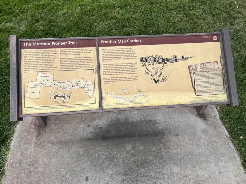
The Mormon Pioneer Trail. Fleeing heated religious and political hostility and persecution, many members of The Church of Jesus Christ of Latter-day Saints (widely known as Mormons) abruptly fled their homes in Nauvoo, Illinois, in February 1846. Unprepared for the Cold of winter, these pioneers traveled 265 agonizing miles in four months. Heavy spring rains that year turned the rolling plains of southern Iowa into a quagmire of axle-deep mud. Sheer exhaustion and lack of provisions continually hampered their efforts triggering he decision to stop and winter over near the banks of the Missouri River. In the spring of 1847, after a respite and an opportunity to make better travel plans, 143 men, three women and two boys stayed across Nebraska for the new Zion on the western slopes of the Rocky Mountains.
Following a rough trace blazed by earlier explorers, fur traders and missionaries, this pioneering group began laying out a route to the West that would later be used by thousands of other Mormons and Forty-niners. These first pioneers established ferries, campsites, bridges, and supply depots—improvements that earned
this page online
Frontier Mail Carriers. Before the postal service established mail routes on the frontier, wagon trains and travelers often exchanged letters to be carried to their destinations or to a post office. On May 4, 1847, the Mormon Pioneer Company and a small band of fur traders from Fort Laramie made such an exchange about eight miles west of this location. Fur trader Charles Beaumont crossed the Platte River and offered to carry letters east to the Missouri River.
John Brown and two other men later crossed the Platte to talk with the traders. Brown reported that the traders said the grass was better on the south side and recommended that the Mormons cross over. Brigham Young called a council, which voted to stay on the north side until they got to Fort Laramie for the sake of those who would follow, showing that the Latter-day Saints were determined to have their own road west.
Farther west, the pioneers wrote messages on scraps of paper for travelers who would come later and stuck them to trees, posts, and the bleached skulls of buffalo—the famous "Bulletin of the Plains."
(sidebar)
These excerpts, selected from thousands of faded Pioneer journals, tell us how it was on the trail for the Mormon Pioneers, who in spite of daily toil, hardships, and death, left us a thousand windows into the past.
Wilford Woodruff, May 4, 1847. “We traveled 3 miles & saw some wagons on the opposite side of the river going down the Platt. Soon one of the men waded the Platt & came to us to see who we were & c. Informed us they were traders from fort Laramie. ... He would take letters to us to Sarpet who lived near winter quarters. So the camp stopped & wrote 52 letters to our familys.”
Wilford Woodruff, May 4, 1847. “We took into consideration the situation of the next company * thousands that would follow after ... we thought it best to keep on the north side of the river & brave the difficulties of Burning Prairies & make A road that should stand as a parmanant rout for the saints indipendant of the old emmigration road ...”
Thomas Bullock, June 8, 1847. “I left a Buffalo Skull written on ‘Pioneers,—Double Teams—8 June 1947. Camp all well. Hail Storm last night. Fine morning. T. Bullock. No accident.’”
Topics. This historical marker is listed in these topic lists: Exploration • Religion & Religious Structures • Roads & Vehicles. A significant historical month for this entry is February 1846.
Location. 40° 40.228′ N, 99° 9.456′ W. Marker is near Kearney, Nebraska, in Buffalo County. It is on the Kearny Eastbound Rest Area (Interstate 80 at milepost 269), 16½ miles east of the Odessa Road interchange (Nebraska Route 108), on the right when traveling east. Touch for map. Marker is at or near this postal address: 23375 I-80, Kearney NE 68845, United States of America. Touch for directions.

Regionally, this marker is in Central Nebraska and in the Platte River Valley. It is also in the American Midwest, in the Corn Belt, and on the prairies. Globally, it is in North America, the Western Hemisphere, the Western World, and the Anglosphere. Historically, it finds itself in what was once the Louisiana Purchase.
Other nearby markers. At least 8 other markers are within 4 miles of this marker, measured as the crow flies: Kearney-Fort Kearny (here, next to this marker); Frontier Forts in Nebraska (within shouting distance of this marker); The Great Plains (approx. 1.9 miles away); The Watson Ranch (approx. 2 miles away); Kearney Cotton Mill (approx. 2.2 miles away); The Frank House (approx. 3.3 miles away); Buffalo County’s Lincoln Highway Seedling Mile (approx. 3.4 miles away); German Baptist Church of the Brethren (approx. 3.6 miles away). Touch for a list and map of all markers in Kearney.
More about this marker. The Mormon Pioneer Trail marker is illustrated with a map of five connected states—Utah, Wyoming, Nebraska, Iowa, and Illinois—showing the trail from Nauvoo to Salt Lake City. An inset map of the United States’ lower 48 shows the location of these five states. The map is captioned
The pioneers of the Mormon trail struggled acros mid-America crossing the Iowa prairie, traversing the Great Plains across Nebraska, climbing the backbone of the continental divide at South Pass, Wyoming, and descending the western slopes of the Rocky Mountains to the Great Salt Lake Valley of Utah.The Frontier Mail Carriers marker is illustrated with maps of Nebraska showing the trail, and a drawing of the pioneers and their wagon at a stop with a bleached buffalo skull in the foreground with this message written on it,
I left a Buffalo Skull written on ‘Pioneers Double Teams 8 June 1947 Camp all well / Hail storm last night / fine morning / T. Bullock / No accident.The map is captioned
The arrow indicates your present location and the dots mark the sites of other interpretive panels across the state. For a brochure with more detailed route information, contact the nearest tourist information office.
Credits. This page was last revised on March 5, 2026. It was originally submitted on June 19, 2025, by Sam Skeen of State College, Pennsylvania. This page has been viewed 205 times since then and 42 times this year. Photo 1. submitted on June 19, 2025, by Sam Skeen of State College, Pennsylvania. • J. J. Prats was the editor who published this page.
Editor’s want-list for this marker. A wide shot of the marker showing it and its environment • Can you help?
