Bloomfield in Davis County, Iowa — The American Midwest (Upper Plains)
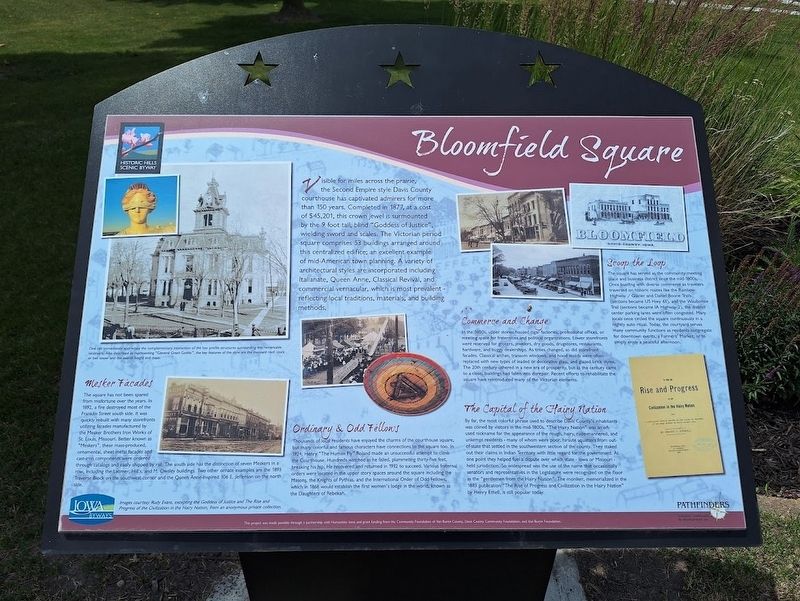
Bloomfield Square
Historic Hills Scenic Byway
Photographed by Jason Voigt, June 16, 2025
1. Bloomfield Square Marker
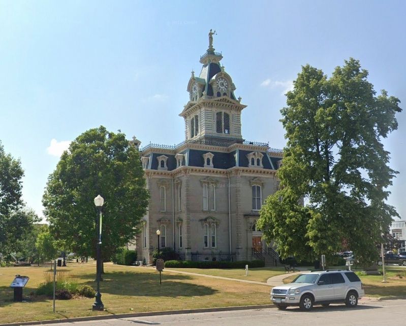
Visible for miles across the prairie, the Second Empire style Davis County courthouse has captivated admirers for more than 150 years. Completed in 1877, at a cost of $45,201, this crown jewel is surmounted by the 9 foot tall, blind "Goddess of Justice", wielding sword and scales. The Victorian period square comprises 53 buildings arranged around this centralized edifice; an excellent example of mid-American town planning. A variety of architectural styles are incorporated including Italianate, Queen Anne, Classical Revival, and commercial vernacular, which is most prevalent - reflecting local traditions, materials, and building methods.
Mesker Facades
The square has not been spared from misfortune over the years. In 1892, a fire destroyed most of the Franklin Street south side. It was quickly rebuilt with many storefronts utilizing facades manufactured by the Meaker Brothers Iron Works of St. Louis, Missouri. Better known as "Meskers", these mass-produced, ornamental, sheet-metal facades and cast-iron components were ordered through catalogs and easily shipped by rail. The south side has the distinction of seven Meskers
this page online
Ordinary & Odd Fellows
Thousands of local residents have enjoyed the charms of the courthouse square, but many colorful and famous characters have connections to the square too. In 1924, Henry "The Human Fly" Roland made an unsuccessful attempt to climb the Courthouse. Hundreds watched as he failed, plummeting thirty-five feet, breaking his hip. He recovered and returned in 1932 to succeed. Various fraternal orders were located in the upper story spaces around the square including the Masons, the Knights of Pythias, and the International Order of Odd Fellows, which in 1868 would establish the first women's lodge in the world, known as the Daughters of Rebekah.
Commerce and Change
In the 1800s, upper stories housed cigar factories, professional offices, or meeting space for fraternities and political organizations. Lower storefronts were reserved for grocers, jewelers, dry goods, drugstores, restaurants, hardware, and buggy
Photographed by Jason Voigt, June 16, 2025
2. Bloomfield Square Marker
Marker is on the southwest corner of Davis County Courthouse grounds.
The Capital of the Hairy Nation
By far, the most colorful phrase used to describe Davis County's inhabitants was coined by visitors in the mid-1800s. "The Hairy Nation" was an oft-used nickname for the appearance of the rough, hairy, rude-mannered, and unkempt residents - many of whom were poor, hirsute squatters from out-of-state that settled in the southwestern section of the county. They staked out their claims in Indian Territory with little regard for the government. At one point they helped fuel a dispute over which state - Iowa or Missouri - held jurisdiction. So widespread was the use of the name that occasionally senators and representatives in the Legislature were recognized on the floor as the "gentlemen from the Hairy Nation". The moniker, memorialized in the 1883 publication "The Rise of Progress and Civilization in the Hairy Nation" by Henry Ethell, is still popular today.
Scoop the Loop
The square has served as the community meeting place and business district since the mid-1800s. Once bustling with diverse commerce as travelers traversed on historic routes like the Rainbow Highway / Glacier and Daniel Boone Trails (sections became US Hwy 63), and the Waubonsie Trail (sections became IA Highway 2), the distinct center parking lanes were often congested. Many locals once circled the square continuously in a nightly auto ritual. Today, the courtyard serves many community functions as residents congregated for downtown events, a Farmers' Market, or to simply enjoy a peaceful afternoon.
(photo caption:)
One can immediately appreciate the complementary interaction of the low profile structures surrounding this remarkable landmark. Also described as representing "General Grant Gothic", the or bell tower and the overall height and mass.
Erected by Iowa Byways and Pathfinders.
Topics. This historical marker is listed in these topic lists: Architecture • Fraternal or Sororal Organizations • Industry & Commerce • Parks & Recreational Areas. A significant historical year for this entry is 1877.
Location. 40° 45.052′ N, 92° 24.836′ W. Marker is in Bloomfield, Iowa, in Davis County. It is at the intersection of East Franklin Street and South Washington Street (U.S. 63), on the right when traveling west on East Franklin Street. Marker is on the grounds of Davis County Courthouse. Touch for map. Marker is at or near this postal address: 111 E Franklin St, Bloomfield IA 52537, United States of America. Touch for directions.

Regionally, this marker is in Southern Iowa. It is also in the American Midwest and in the Corn Belt. Globally, it is in North America, the Western Hemisphere, the Western World, and the Anglosphere. Historically, it finds itself in what was once the territory of the Mississippian Culture and also the Louisiana Purchase.
Other nearby markers. At least 8 other markers are within 5 miles of this marker, measured as the crow flies: Davis County Courthouse (a few steps from this marker); Veterans Memorial (within shouting distance of this marker); Replica of the Statue of Liberty (within shouting distance of this marker); In Memory of General and Mrs. James B. Weaver (approx. 0.3 miles away); The Weaver House (approx. 0.3 miles away); The Confederate Invasion of Iowa Monument (approx. 0.7 miles away); A New Route (approx. 4.9 miles away); Davis County Freedom Rock (approx. 4.9 miles away). Touch for a list and map of all markers in Bloomfield.
Credits. This page was last revised on June 20, 2025. It was originally submitted on June 20, 2025, by Jason Voigt of Glen Carbon, Illinois. This page has been viewed 162 times since then and 26 times this year. Photos: 1, 2. submitted on June 20, 2025, by Jason Voigt of Glen Carbon, Illinois.
