Northwest in Virginia Beach, Virginia — The American South (Mid-Atlantic)
Battle of the Capes, September 5, 1781
Photographed by Devry Becker Jones (CC0), June 11, 2025
1. Battle of the Capes, September 5, 1781 Marker
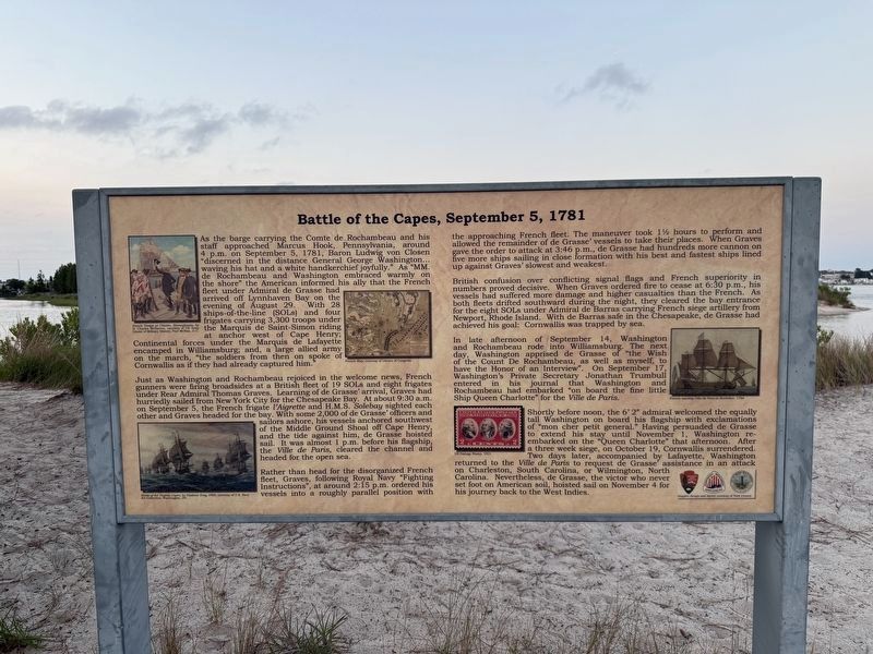
As the barge carrying the Comte de Rochambeau and his staff approached Marcus Hook, Pennsylvania, around 4 p.m. on September 5, 1781, Baron Ludwig von Closen "discerned in the distance General George Washington… waving his hat and a white handkerchief joyfully." As "MM. de Rochambeau and Washington embraced warmly on the shore" the American informed his ally that the French fleet under Admiral de Grasse had arrived off Lynnhaven Bay on the evening of August 29. With 28 ships-of-the-line (SOLs) and four frigates carrying 3,300 troops under the Marquis de Saint-Simon riding at anchor west of Cape Henry; Continental forces under the Marquis de Lafayette encamped in Williamsburg; and, a large allied army on the march, "the soldiers from then on spoke of Cornwallis as if they had already captured him."
Just as Washington and Rochambeau rejoiced in the welcome news, French gunners were firing broadsides at a British fleet of 19 SOLs and eight frigates under Rear Admiral Thomas Graves. Learning of de Grasse' arrival, Graves had hurriedly sailed from New York City for the Chesapeake Bay. At about 9:30 a.m. on September 5,
this page online
Rather than head for the disorganized French fleet, Graves, following Royal Navy "Fighting Instructions", at around 2:15 p.m. ordered vessels into a roughly parallel position with the approaching French fleet. the maneuver took 1½ hours to perform and allowed the remainder of de Grasse' vessels to take their places. When Graves gave the order to attack at 3:46 p.m., de Grasse had hundreds more cannon on five more ships sailing in close formation with his best and fastest ships lined up against Graves' slowest and weakest.
British confusion over conflicting signal flags and French superiority in numbers proved decisive. When Graves ordered fire to cease at 6:30 p.m., his vessels had suffered more damage and higher casualties than the French. As
Photographed by Devry Becker Jones (CC0), June 11, 2025
2. Battle of the Capes, September 5, 1781 Marker
In late afternoon of September 14, Washington and Rochambeau rode into Williamsburg. The next day, Washington apprised de Grasse of "the Wish of the Count De Rochambeau, as well as myself, to have the Honor of an Interview". On September 17, Washington's Private Secretary Johnathan Trumbull entered in his journal that Washington and Rochambeau had embarked "on board the fine little Ship Queen Charlotte" for the Ville de Paris.
Shortly before noon, the 6' 2" admiral welcomed the equally tall Washington on board his flagship with exclamations of "mon cher petit general." Having persuaded de Grasse to extend his stay until November 1, Washington re-embarked on the "Queen Charlotte" that afternoon. After a three week siege, on October 19, Cornwallis surrendered. Two days later, accompanied by Lafayette, Washington returned to the Ville de Paris to request de Grasse' assistance in an attack on Charleston, South Carolina, or Wilmington, North Carolina. Nevertheless, de Grasse, the victor who never set foot on American soil, hoisted sail on November 4 for his journey back to the West Indies.
Erected by National Park Service, U.S. Department of the Interior; City of Virginia beach, Virginia.
Topics. This historical marker is listed in these topic lists: War, US Revolutionary • Waterways & Vessels. A significant historical date for this entry is September 5, 1781.
Location. 36° 54.251′ N, 76° 5.757′ W. Marker is in Virginia Beach, Virginia. It is in Northwest. It can be reached from Marlin Bay Drive east of Winston Place, on the right when traveling east. Touch for map. Marker is at or near this postal address: 3608 Marlin Bay Dr, Virginia Beach VA 23455, United States of America. Touch for directions.

Regionally, this marker is in Hampton Roads, specifically in Coastal Virginia, and in the Hampton Roads Metropolitan Area. It is also in the American South, specifically in the Upper South, in the Tidewater, and on the Eastern Seaboard. Globally, it is in the North Atlantic Region, North America, the Western Hemisphere, the Western World, and the Anglosphere. Historically, it finds itself in what was once the territory of the Mississippian Culture, one of the original Thirteen Colonies, one of the Confederate States of America, and the Antebellum South.
Other nearby markers. At least 8 other markers are within 2 miles of this marker, measured as the crow flies: The Oyster Barge (within shouting distance of this marker); Fisheries / Blue Crab (within shouting distance of this marker); a different marker also named The Oyster Barge (within shouting distance of this marker); The Canoes, 2018 (approx. ¼ mile away); Protecting Our Waterways and Wildlife (approx. ¾ mile away); Meeting of Three Commanders (approx. one mile away); Church Point (approx. 1.2 miles away); Thorowgoods in the Revolution (approx. 1.2 miles away). Touch for a list and map of all markers in Virginia Beach.
Credits. This page was last revised on August 29, 2025. It was originally submitted on June 21, 2025, by Devry Becker Jones of Washington, District of Columbia. This page has been viewed 241 times since then and 69 times this year. Photos: 1, 2. submitted on June 21, 2025, by Devry Becker Jones of Washington, District of Columbia.
