
Near Keystone in Pennington County, South Dakota — The American Midwest (Upper Plains)
Significant Black Hills Native American Sites
| — | Mount Rushmore National Memorial | — |
Photographed by Mark Parker, June 30, 2025
1. Significant Black Hills Native American Sites Marker
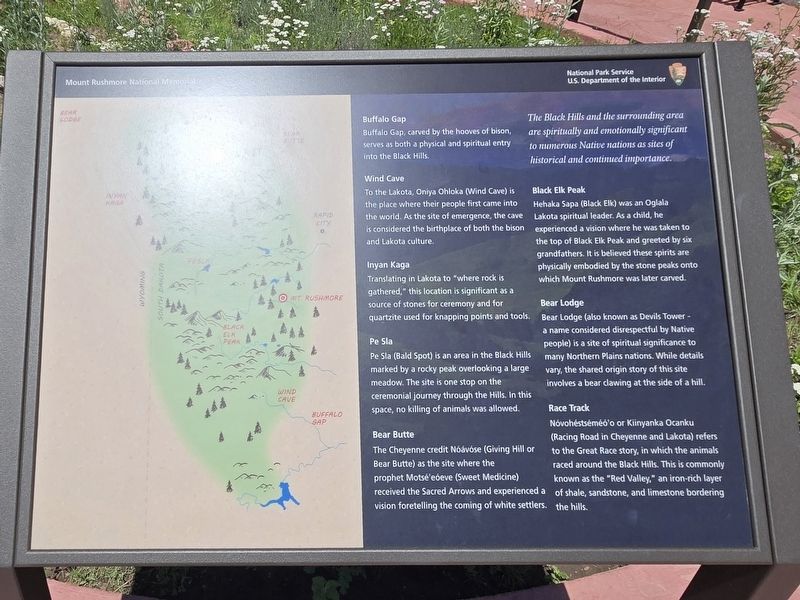
The Black Hills and the surrounding area are spiritually and emotionally significant to numerous Native nations as sites of historical and continued importance.
Buffalo Gap
Buffalo Gap, carved by the hooves of bison, serves as both a physical and spiritual entry into the Black Hills.
Wind Cave
To the Lakota, Oniya Ohloka (Wind Cave) is the place where their people first came into the world. As the site of emergence, the cave is considered the birthplace of both the bison and Lakota culture.
Inyan Kaga
Translating in Lakota to "where rock is gathered," this location is significant as a source of stones for ceremony and for quartzite used for knapping points and tools.
Pe Sla
Pe Sla (Bald Spot) is an area in the Black Hills marked by a rocky peak overlooking a large meadow. The site is one stop on the ceremonial journey through the Hills. In this space, no killing of animals was allowed.
Bear Butte
The Cheyenne credit Nóávóse (Giving Hill or Bear Butte) as the site where the prophet Motsé'eóeve (Sweet Medicine) received the Sacred Arrows and experienced a vision foretelling the coming of white settlers.
this page online
Black Elk Peak
Hehaka Sapa (Black Elk) was an Oglala Lakota spiritual leader. As a child, he experienced a vision where he was taken to the top of Black Elk Peak and greeted by six grandfathers. It is believed these spirits are physically embodied by the stone peaks onto which Mount Rushmore was later carved.
Bear Lodge
Bear Lodge (also known as Devil's Tower - a name considered disrespectful by Native people) is a site of spiritual significance to many Northern Plains nations. While details vary, the shared origin story of this site involves a bear clawing at the side of a hill.
Race Track
Nóvohéstéméó'o or Kiinyanka Ocanku (Racing Road in Cheyenne and Lakota) refers to the Great Race story, in which the animals raced around the Black Hills. This is commonly known as the "Red Valley," an iron-rich layer of shale, sandstone, and limestone bordering the hills.
Erected by National Park Service, U.S. Department of the Interior.
Topics. This historical marker is listed in this topic list: Indigenous Peoples and Communities.
Location. 43° 52.543′ N, 103° 27.223′ W.

Photographed by Mark Parker, June 30, 2025
2. Significant Black Hills Native American Sites Marker with other markers at Mt Rushmore Park entrance

Regionally, this marker is in South Dakota’s West River, in the Badlands, and in Greater Rapid City. It is also in the American Black Hills, in the Lewis & Clark Corridor, on the prairies, and on the Northern Plains. Globally, it is in North America, the Western Hemisphere, the Western World, and the Anglosphere. Historically, it finds itself in what was once Rupert’s Land and also the Louisiana Purchase.
Other nearby markers. At least 8 other markers are within walking distance of this marker: Traditional Ecological Knowledge (here, next to this marker); Ancient Stone Circles (here, next to this marker); Celestial and Earthly Locations (here, next to this marker); "We Are Still Here" (a few steps from this marker); Rushmore Workers (about 500 feet away, measured in a direct line); History of the United States of America (approx. 0.2 miles away); (Mount Rushmore) Chronology (approx. 0.2 miles away); The Power to Carve a Mountain (approx. 0.2 miles away). Touch for a list and map of all markers in Keystone.
More about this marker. The marker is at Mt. Rushmore National Memorial. It is located between the parking decks and the entrance to the park.
Credits. This page was last revised on July 5, 2025. It was originally submitted on July 2, 2025, by Mark Parker of Hickory, North Carolina. This page has been viewed 212 times since then and 86 times this year. Photos: 1, 2. submitted on July 2, 2025, by Mark Parker of Hickory, North Carolina. • J. Makali Bruton was the editor who published this page.
