Webster Station in Dayton in Montgomery County, Ohio — The American Midwest (Great Lakes)
The Rebuilding - Fire Blocks and Merchants Row
| — | Patterson Boulevard Canal Parkway | — |
Photographed by Craig Doda, June 28, 2025
1. The Rebuilding - Fire Blocks and Merchants Row Marker
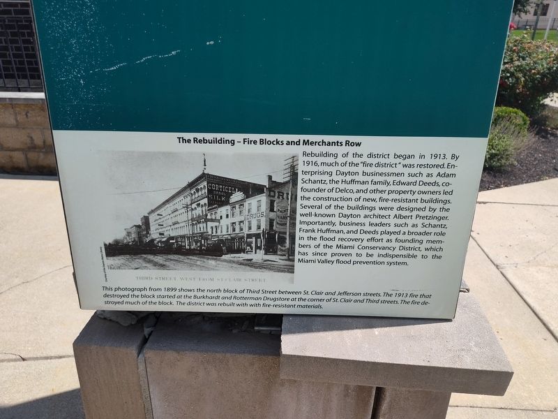
Rebuilding of the district began in 1913. By 1916, much of the "fire district" was restored. Enterprising Dayton businessmen such as Adam Schantz, the Huffman family, Edward Deeds, co-founder of Delco, and other property owners led the construction of new, fire-resistant buildings. Several of the buildings were designed by the well-known Dayton architect Albert Pretzinger. Importantly, business leaders such as Schantz, Frank Huffman, and Deeds played a broader role in the flood recovery effort as founding members of the Miami Conservancy District, which has since proven to be indispensible to the Miami Valley flood prevention system.
This photograph from 1899 shows the north block of Third Street between St. Clair and Jefferson streets. The 1913 fire that destroyed the block started at the Burkhardt and Rotterman Drugstore at the corner of St. Clair and Third streets. The fire destroyed much of the block. The district was rebuilt with with fire-resistant materials.
Topics. This historical marker is listed in these topic lists: Architecture • Industry & Commerce • Waterways & Vessels. A significant historical year for this entry is 1913.
Location. 39° 45.544′ N,
this page online

Regionally, this marker is in the Miami Valley. It is also in the American Midwest and in the Corn Belt. Globally, it is in North America, the Western Hemisphere, the Western World, and the Anglosphere. Historically, it finds itself in what was once the Haudenosaunee (Iroquois) Confederacy, the territory of the Mississippian Culture, and the Northwest Territory.
Other nearby markers. At least 8 other markers are within walking distance of this marker: The Beaver Power Building (here, next to this marker); Fire Blocks - The Flood and the Fire (here, next to this marker); The Fire Blocks - Merchants Row (here, next to this marker); Canal Buildings of the Past (here, next to this marker); Dayton Canal-Era Timeline (here, next to this marker);
Photographed by Craig Doda, June 28, 2025
2. The Rebuilding - Fire Blocks and Merchants Row Marker
Credits. This page was last revised on July 26, 2025. It was originally submitted on July 6, 2025, by Craig Doda of Napoleon, Ohio. This page has been viewed 84 times since then and 32 times this year. Photos: 1, 2. submitted on July 6, 2025, by Craig Doda of Napoleon, Ohio. • Devry Becker Jones was the editor who published this page.
