
Downtown in Dayton in Montgomery County, Ohio — The American Midwest (Great Lakes)
The Canal and the Railroad
| — | Patterson Boulevard Canal Parkway | — |
Photographed by Craig Doda, July 5, 2025
1. The Canal and the Railroad Marker
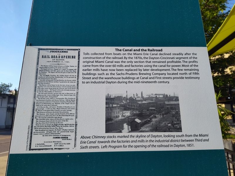
Tolls collected from boats on the Miami Erie Canal declined steadily after the construction of the railroad. By the 1870s, the Dayton-Cincinnati segment of the original Miami Canal was the only section that remained profitable. The profits came from the over 60 mills and factories using the canal for power. Most of the earlier mills have now been replaced by later development. The few remaining buildings such as the Sachs-Prudens Brewing Company located north of Fifth Street and the warehouse buildings at Canal and First streets provide testimony to an industrial Dayton during the mid-nineteenth century.
Above: Chimney stacks marked the skyline of Dayton, looking south from the Miami Erie Canal towards the factories and mills in the industrial district between Third and Sixth streets. Left: Program for the opening of the railroad in Dayton, 1851.
Topics. This historical marker is listed in these topic lists: Architecture • Industry & Commerce • Railroads & Streetcars • Waterways & Vessels. A significant historical year for this entry is 1851.
Location. 39° 45.427′ N, 84° 11.271′ W. Marker is in Dayton,
this page online

Regionally, this marker is in Ohio’s Miami Valley. It is also in the American Midwest and in the Corn Belt. Globally, it is in North America, the Western Hemisphere, the Western World, and the Anglosphere. Historically, it finds itself in what was once the Haudenosaunee (Iroquois) Confederacy, the territory of the Mississippian Culture, and the Northwest Territory.
Other nearby markers. At least 8 other markers are within walking distance of this marker: The Canal, by the Numbers (here, next to this marker); Towpaths (here, next to this marker); Aqueducts (here, next to this marker); Dayton and the Canal: Timeline (here, next to this marker); Anatomy of a Canal Lock (here, next to this marker); Constructing the Canal (here, next to this marker); Bridges (here, next to this marker); The Oregon District
Photographed by Craig Doda, July 5, 2025
2. The Canal and the Railroad Marker
Credits. This page was last revised on July 26, 2025. It was originally submitted on July 6, 2025, by Craig Doda of Napoleon, Ohio. This page has been viewed 82 times since then and 17 times this year. Photos: 1, 2. submitted on July 6, 2025, by Craig Doda of Napoleon, Ohio. • Devry Becker Jones was the editor who published this page.
