Quanah in Hardeman County, Texas — The American South (West South Central)
Quanah Commercial Historic District
Photographed by Cosmos Mariner, July 6, 2025
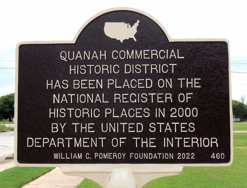
1. Quanah Commercial Historic District Marker
Has been placed on the National Register of Historic Places in 2000 by the United States Department of the Interior
Erected 2022 by William G. Pomeroy Foundation. (Marker Number 460.)
Topics and series. This historical marker is listed in these topic lists: Architecture • Industry & Commerce • Railroads & Streetcars • Roads & Vehicles. In addition, it is included in the National Register of Historic Places (NRHP), and the William G. Pomeroy Foundation series lists. A significant historical year for this entry is 1890.
Location. 34° 17.856′ N, 99° 44.371′ W. Marker is in Quanah, Texas, in Hardeman County. It is at the intersection of South Main Street and East 3rd Street, on the right when traveling north on South Main Street. The marker is located at the southeast corner of the intersection. Touch for map. Marker is at or near this postal address: 301 South Main Street, Quanah TX 79252, United States of America. Touch for directions.

Regionally, this marker is in Big Country. It is also on the American Great Plains and specifically on the Southern Plains. Globally, it is in North America, a Gulf
this page online
Other nearby markers. At least 8 other markers are within walking distance of this marker: Quanah Parker (within shouting distance of this marker); Hardeman County Courthouse (about 300 feet away, measured in a direct line); First Presbyterian Church of Quanah (about 600 feet away); Quanah Parker Trail (about 700 feet away); Quanah, Acme and Pacific Depot (about 800 feet away); Hardeman County Jail (approx. 0.2 miles away); Trinity Church of Quanah (approx. ¼ mile away); Hardeman County (approx. 0.8 miles away). Touch for a list and map of all markers in Quanah.
Regarding Quanah Commercial Historic District. National Register of Historic Places № 00000475.
From the National Register Nomination prepared by Kate Singleton and Norman Alston, 1/1999:
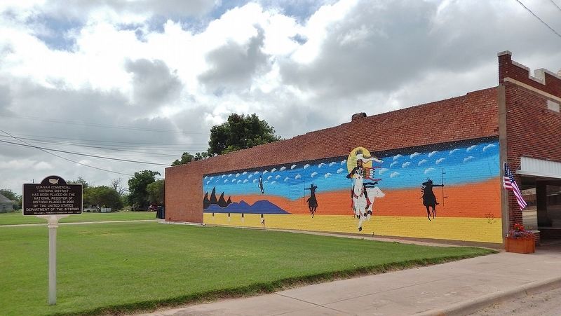
The Quanah Commercial Historic District contains the core of the community's historic downtown. The district contains a high concentration of historicproperties that represent significant periods of the physical, economic, and governmental development of Quanah and Hardeman County.Photographed by Cosmos Mariner, July 6, 20252. Quanah Commercial Historic District MarkerLooking southeast from the South Main Street and East 3rd Street intersection. The marker is located at the southeast corner of the intersection — roughly at the center of the Commercial Historic District.
The northern boundary is formed by the tracks of the Burlington Northern Railroad, creating a strong associative link between the district's commercial enterprises and the rail line. The eastern boundary delineates the commercial area from residential development. Fifth Street forms the southern boundary of the historic commercial edge of downtown. The western boundary along Fifth Street separates the historic western edge of the downtown commercial area from post-1950's development. The boundaries of the district include a small number of residential buildings that were constructed within the period of significance.
Erected primarily between 1890 and 1930, to house commercial or retail ventures, a majority of the buildings in the district are one or two-part commercial blocks composed of brick or stone. Within the district are several important non-commercial buildings, including the Hardeman County Courthouse, the Hardeman County Jail, and the First Presbyterian Church.
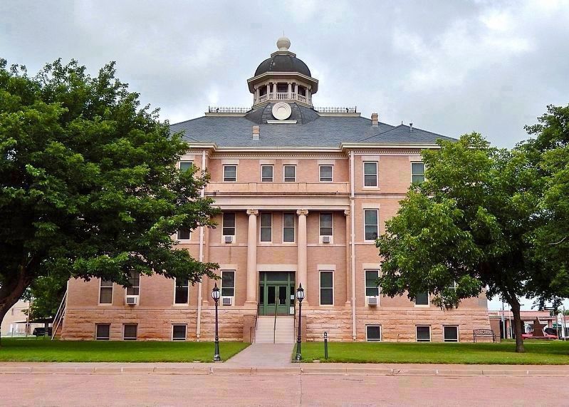
The district occupies land characterizedby a grid pattern of streets and blocks. The majority of the properties are situated along four blocks of South Main Street, a primary north-south street cutting through the center of the district. The streets within the district are generally asphalt surfaced, with isolated sections of roadway showing original brick pavers.Photographed by Cosmos Mariner, July 6, 20253. Hardeman County Courthouse (1910)
300 South Main StreetFrom the National Register Nomination: In September of 1906, the County Commissioners voted to build the current courthouse. The Hardeman County Courthouse was constructed in 1906-1907 by local contracting firm Tom Lovell and Sons Contractors, after a design of regional architect R.H. Stuckey. The building is Neo-Classical in style and is constructed of tan brick with a rusticated stone base and topped with an octagonal cupola painted silver. The three-story building presents a symmetrical facade, with a central recessed entry bay sheltered by a two-story porch. The front facade porch features Ionic columns, while the pediment on the rear porch contains a carved star. Like many Texas courthouses, it is designed on a cruciform plan.
The automobile played a significant role in the development of Quanah. U.S. Highway 287, historically known as the North Texas Highway, developed as a major east-west route through Northwest Texas during the 1930s. A number of gas stations and auto-related buildings were built along Main Street to service motorists traveling on the North Texas Highway between Wichita Falls and Amarillo. By 1930, there were seven gas stations in the downtown area.
Although the loss of the cotton gins, lumber yards, and elements of the railroad have changed the character of the area, the overall integrity of the historic district is intact. There are adequate resources remaining that were built by and tied to the economic engines of these industries to illustrate the history of Quanah.
Related markers. Click here for a list
Photographed by Cosmos Mariner, July 6, 2025
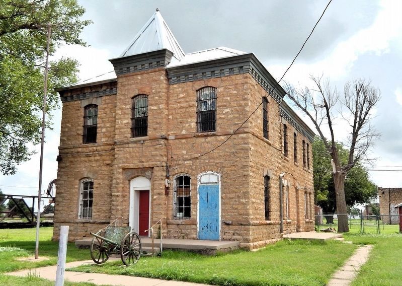
4. Hardeman County Jail (1890)
107 Green Street
107 Green Street
From the National Register Nomination: Built between 1890-1891, the County Jail is the oldest governmental building in Quanah. General Grenville Dodge, an engineer and railroad townsite promoter, purchased the land for the jail for $570. Construction began in 1890, with the Pauley Jail Building and Manufacturing Company of St. Louis, Missouri, acting as the contractor. The building cost $9,225 to construct and is made of native stone most likely taken from the nearby Pease River. The two-story structure jail features a projecting central tower topped with a pyramidal cap. The core of the building is sheltered by a hipped, metal seam roof. The front facade contains arched, wood-frame windows covered with iron bar. Decorative treatment to the building is minimal and consists mainly of a decorative brick cornice.
Photographed by Cosmos Mariner, July 6, 2025
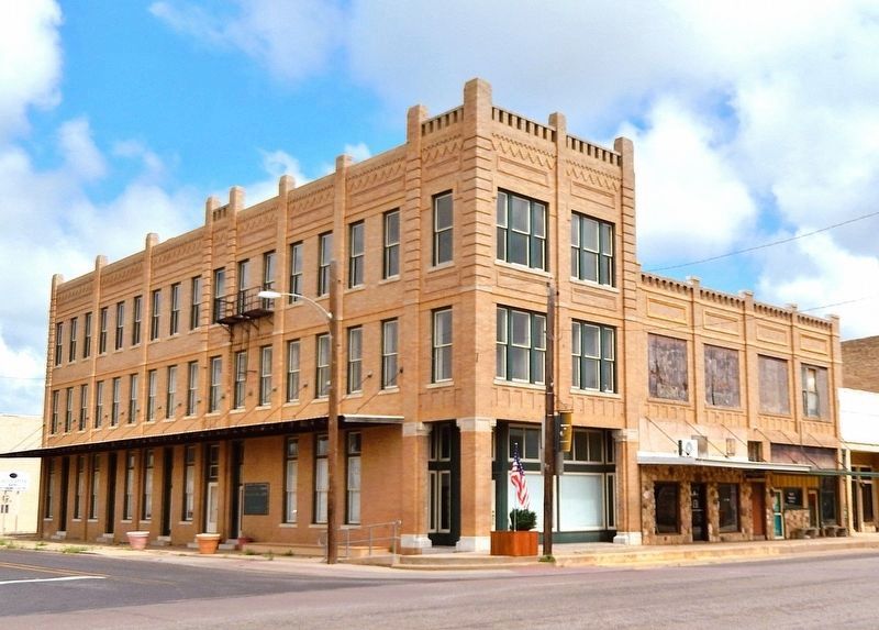
5. Simpson Building (1910)
222 South Main Street
222 South Main Street
From the National Register Nomination: Constructed in 1910 by L.E. Simpson, a prominent local citizen who owned a lumber yard and real estate company in Quanah. Situated on a major downtown corner, this three-story building is composed of tan brick and is distinguished by its corbeled frieze course. A variation of the same brick detailing carries over to 220 and 218 South Main Street erected at the same time by G.A. Vestal. Simpson and Vestal came to an agreement over the construction of the buildings, specifying that a fire wall be built between the two structures. The first-floor storefronts maintain their rhythm but have had their original walls covered with a modern stone veneer.
Photographed by Cosmos Mariner, July 6, 2025
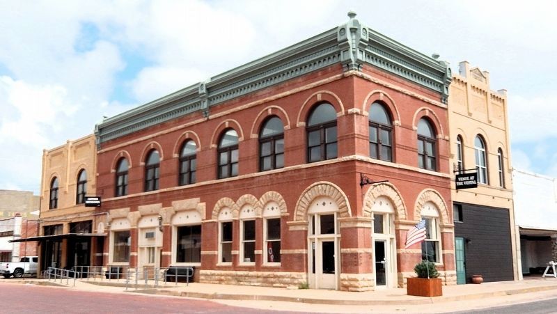
6. Citizens National Bank (1891) & Vestal Building (1910)
120 and 122 South Main Street
120 and 122 South Main Street
From the National Register Nomination: The commercial buildings at 120 and 122 South Main Street are two-part commercial structures. The first building, 122, was constructed in 1891 as the Citizens National Bank. This building features Richardsonian Romanesque elements in the relieving round arches over the entrances and windows on the first floor. The arched second floor windows reveal a similar treatment, but with less stonework. The building is capped with an ornate metal cornice. The building at 120 South Main, also known as the Vestal Building, was constructed around 1910. This two-story brick building has arched second-story windows with a decorative brick frieze and pedimented date stone above the cornice.
Photographed by Cosmos Mariner, July 6, 2025
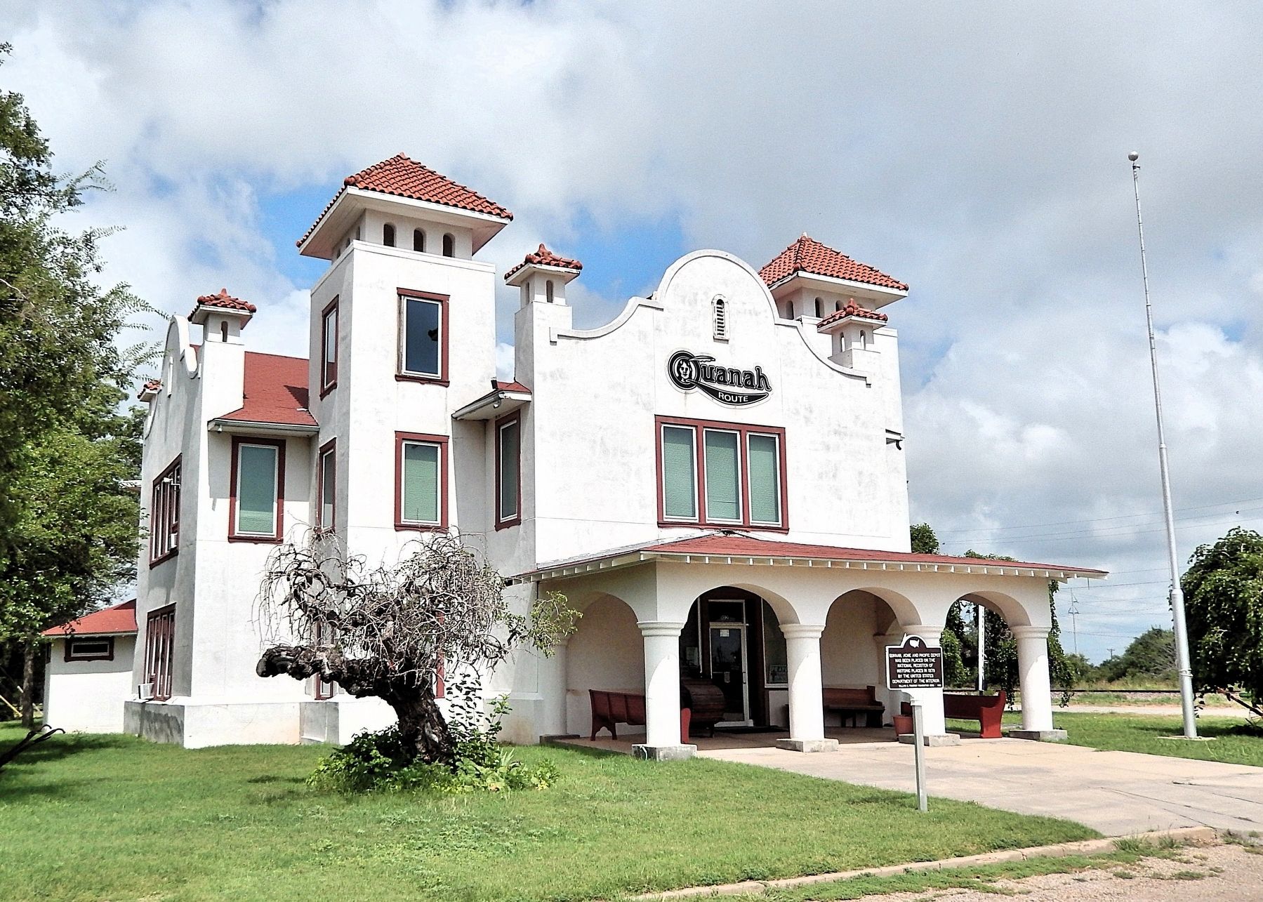
7. Quanah, Acme and Pacific Depot (1909)
102 Mercer Street
102 Mercer Street
From the National Register Nomination: The Quanah, Acme and Pacific Depot was constructed in 1909 and opened to the public on January 5, 1910. The building was designed as a passenger station and served as the offices for the Quanah, Acme and Pacific Railway. During the time of its construction, Sam Lazarus was president of the railroad, which had recently changed its name from the Acme, Red River and Northern to the QA&P. C.H. Page and Brothers of Austin designed the impressive Spanish Colonial Revival style structure, apparently reflecting the design of the Texas Pavilion at the 1893 World's Fair in Chicago. Built on a simple cross-axis plan, the building displays a symmetrical facade featuring a center Mission-shaped parapet and two small towers at either end. Two large bell towers are set back on either side of the front entry along the cross-axis. The side gables are detailed with similar Mission-shaped parapets as the front facade. The arcade front entry porch carries a hipped roof supported by four large round columns. The towers and porches are covered with red tile, while the roof of the rest of the building is of a modern composite material. At some time in its history, the station was whitewashed. Other changes to the building include the replacement of the original doors with metal designs and boarding over the upper story windows.
Credits. This page was last revised on July 8, 2025. It was originally submitted on July 7, 2025, by Cosmos Mariner of Cape Canaveral, Florida. This page has been viewed 250 times since then and 54 times this year. Photos: 1, 2, 3, 4. submitted on July 7, 2025, by Cosmos Mariner of Cape Canaveral, Florida. 5, 6, 7. submitted on July 8, 2025, by Cosmos Mariner of Cape Canaveral, Florida.
