Mackinac Island in Mackinac County, Michigan — The American Midwest (Great Lakes)
The Treaty of Washington, 1836
| — | Native American Cultural History Trail | — |
Photographed by Joel Seewald, July 1, 2025
1. The Treaty of Washington, 1836 Marker, Side One
Side 1
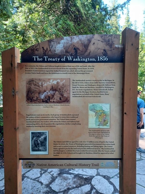
For centuries, the Odawa and Ojibway fought to control their way of life and lands. After the War of 1812, the Anishnaabek faced new threats from the expanding United States. In 1830, President Andrew Jackson signed the Indian Removal Act, which allowed the government to seize Native lands and force inhabitants to resettle west of the Mississippi River.
The Anishnaabek needed a treaty to stay in Michigan. In the fall of 1835, Odawa from the Little Traverse, Grand River, Grand Traverse, and Muskegon, along with Ojibway from Sault Ste. Marie and Mackinac, travelled to Washington, D.C. for treaty negotiations. Henry Schoolcraft, Indian agent for the Michigan Territory, handled treaty negotiations on behalf of the United States. Many Anishnaabek did not trust Schoolcraft.
Negotiations went on for weeks. Each group of Anishnaabek expressed the wishes of their communities, who hoped to retain their traditional lands and receive government annuities. The United States wanted Anishnaabek land. Fur traders, with whom the Odawa and Ojibway had outstanding debts, also frequented the negotiations, further complicating
this page online
The Odawa and Ojibway agreed to cede over 13 million acres of land to the United States. In return, the Treaty of Washington guaranteed permanent reservation lands and access to natural resources, including hunting and fishing rights. The United States agreed to pay for the land and provide additional services. The Anishnaabek left Washington confident they had avoided forced removal. After the Senate ratified the treaty in 1836, Schoolcraft brought it to Mackinac Island for approval by tribal leaders.
Top image caption: Alfred Waud sketched this Native camp at Mackinac Island's British Landing in 1853.
Middle image caption: The Anishnaabek agreed to cede much of their land, highlighted on this map in yellow, to the United States through the 1836 Treaty of Washington.
Side 2
Continued from other side
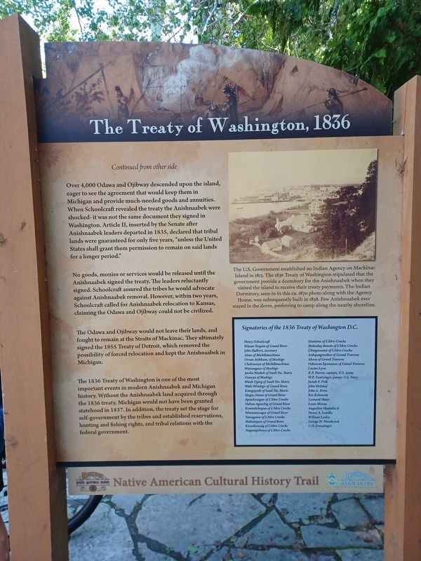
Over 4,000 Odawa and Ojibway descended upon the island, eager to see the agreement that would keep them in Michigan and provide much-needed goods and annuities. When Schoolcraft revealed the treaty the Anishnaabek were shocked- it was not the same document they signed in Washington.
Photographed by Joel Seewald, July 1, 2025
2. The Treaty of Washington, 1836 Marker, Side Two
No goods, monies or services would be released until the Anishnaabek signed the treaty. The leaders reluctantly signed. Schoolcraft assured the tribes he would advocate against Anishnaabek removal. However, within two years, Schoolcraft called for Anishnaabek relocation to Kansas, claiming the Odawa and Ojibway could not be civilized.
The Odawa and Ojibway would not leave their lands, and fought to remain at the Straits of Mackinac. They ultimately signed the 1855 Treaty of Detroit, which removed the possibility of forced relocation and kept the Anishnaabek in Michigan.
The 1836 Treaty of Washington is one of the most important events in modern Anishnaabek and Michigan history. Without the Anishnaabek land acquired through the 1836 treaty, Michigan would not have been granted statehood in 1837. In addition, the treaty set the stage for self-government by the tribes and established reservations,
Photographed by Joel Seewald, July 1, 2025
3. The Treaty of Washington, 1836 Marker
Inset box:
Signatories of the 1836 Treaty of Washington D.C.
| Henry Schoolcraft | Onaisino of L'Abre Croche |
| Wasaw Bequm of Grand River | Mukuday Benais of L'Abre Croche |
| John Hulbert, secretary | Chingassamo of L'Abre Croche |
| Ainse of Michilimackinac | Aishquagonabee of Grand Traverse |
| Oroun Aishkum, of Maskigo | Akosa of Grand Traverse |
| Chabowaya of Michilimackinac | Oshawun Epenaysee of Grand Traverse |
| Wassangaze of Maskigo | Lucius Lyon |
| Jawba Wadiek of Sault Ste. Marie | R.P. Parrot, captain, U.S. Army |
| Osawya of Maskigo | W.P. Zantzinger, purser, U.S. Navy |
| Waub Ogeeg of Sault Ste. Marie | Josiah F. Polk |
| Wabi Windego of Grand River | John Holiday |
| Kawgayosh of Sault Ste. Marie | John A. Drew |
| Megiss Ininee of Grand River | Rix Robinson |
| Apawkozigun of L'Abre Croche | Leonard Slater |
| Nabun Ageezhig of Grand River | Louis Moran |
| Keminitchagun of L'Abre Croche | Augustine Hamelin Jr. |
| Winnimissagee of Grand River | Henry A. Lenake |
| Tawaganee of L'Abre Croche | William Lasley |
| Mukutaysee of Grand River | George W. Woodward |
| Kinoshamaig of L'Abre Croche | C.O. Ermatinger |
| Naganigobowa of L'Abre Croche |
Erected 2017 by Mackinac State Historic Parks and Mackinac Associates.
Topics. This historical marker is listed in these topic lists: Indigenous Peoples and Communities • Peace. A significant historical year for this entry is 1812.
Location. 45° 51.883′ N, 84° 38.964′ W. Marker is on Mackinac Island, Michigan, in Mackinac County. It is on Lake Shore Boulevard, on the left when traveling south. Marker is about halfway between mile markers 5 and 6. Touch for map. Marker is in this post office area: Mackinac Island MI 49757, United States of America. Touch for directions.

Regionally, this marker is on the Upper Peninsula and on the Straits of Mackinac. It is also in the American Midwest. Globally, it is in North America, in the Great North Woods, on the Great Lakes, in the Western Hemisphere, in the Western World, and in the Anglosphere. Historically, it finds itself in what was once the Viceroyalty of New France and also the Northwest Territory.
Other nearby markers. At least 8 other markers are within 2 miles of this marker, measured as the crow flies: British Landing (approx. 0.9 miles away); The Ice Bridge (approx. 0.9 miles away); The Mackinac Bridge (approx. 0.9 miles away); Limestone Breccia (approx. 0.9 miles away); Contest for the Island (approx. 0.9 miles away); Devil's Kitchen (approx. one mile away); The Anishnaabek in the 21st Century (approx. 1.3 miles away); Post Cemetery (approx. 1.4 miles away). Touch for a list and map of all markers in Mackinac Island.
Also see . . .
1. Treaty of Washington (1836). Wikipedia article about the 1836 Treaty of Washington. (Submitted on July 9, 2025, by Joel Seewald of Madison Heights, Michigan.)
2. Treaty of Detroit (1855). Wikipedia article about the 1855 Treaty of Detroit. (Submitted on July 9, 2025, by Joel Seewald of Madison Heights, Michigan.)
Credits. This page was last revised on July 10, 2025. It was originally submitted on July 9, 2025, by Joel Seewald of Madison Heights, Michigan. This page has been viewed 238 times since then and 79 times this year. Photos: 1, 2, 3. submitted on July 9, 2025, by Joel Seewald of Madison Heights, Michigan.
