
Niagara Falls in Niagara Region, Ontario — Central Canada (North America)
Niagara Tunnel Project
Photographed by Kevin Westell, July 3, 2025
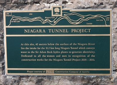
1. Niagara Tunnel Project - Marker
Erected by STRABAG Construction Company of Austria.
Topics. This historical marker is listed in these topic lists: Industry & Commerce • Waterways & Vessels. A significant historical year for this entry is 2005.
Location. 43° 4.139′ N, 79° 3.514′ W. Marker is in Niagara Falls, Ontario, in Niagara Region. It is on Niagara River Parkway, on the right when traveling west. The marker is on the Trans Canada Trail, just south of the control building for the International Control Building. Touch for map. Marker is at or near this postal address: 7700 Niagara River Pkwy, Niagara Falls ON L2G 5Y7, Canada. Touch for directions.

Regionally, this marker is on Ontario’s Golden Horseshoe and in Niagara Canada. It is also in Central Canada. Globally, it is in North America, on the Great Lakes, in
this page online
Other nearby markers. At least 8 other markers are within walking distance of this marker: Niagara Control Works (within shouting distance of this marker); Bridgewater Mills (approx. 0.7 kilometers away); Ontario Power Screen House (approx. 0.8 kilometers away); Laura (Ingersoll) Secord (approx. 0.8 kilometers away); Church of the Holy Trinity (approx. 0.8 kilometers away); Gate House (approx. 0.9 kilometers away); Raid on Fort Schlosser 1813 (approx. one kilometer away); Fort Chippawa 1791 (approx. one kilometer away). Touch for a list and map of all markers in Niagara Falls.
More about this marker. For clarity on naming: a new-ish tourist attraction just north of here is named "The Tunnel at the Niagara Parks Power Station". That was part of a "small", obsolete, now-closed generating station, and its related de-watered tunnel that people can walk through.
Regarding Niagara Tunnel Project. As

Photographed by Kevin Westell, July 3, 2025
2. Niagara Tunnel Project - Marker in context
Photo faces west. The Niagara River Parkway is in the left background.
- The Chippawa-Queenston power canal, completed 1922 for Sir Adam Beck I
- Two tunnels, completed 1954 for Sir Adam Beck II. (These are the tunnels with the two giant emergency doors nearby). These are each 13.7 metres (45 ft) in diameter.
- This additional tunnel, completed 2013, as part of upgrades to Sir Adam Beck II. It is 12.7 metres (42 ft) in diameter.
Photographed by Kevin Westell, July 3, 2025
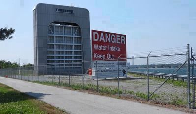
3. Emergency Gate (for one of the two older 1950's diversion tunnels)
Unrelated to this new tunnel project (described by the marker): 250 and 400 metres south, the two older 1950's diversion tunnels each has an enormous emergency gate, that can drop by gravity, to block flow through the tunnel, in the event of emergency. This illustrates the proximity of the new tunnel to the two older tunnels; and its size. For scale: that frost fence is 3 m (10 ft) high.
Credits. This page was last revised on December 22, 2025. It was originally submitted on July 11, 2025, by Kevin Westell of St. Catharines, Ontario. This page has been viewed 104 times since then and 58 times this year. Photos: 1, 2, 3. submitted on July 11, 2025, by Kevin Westell of St. Catharines, Ontario. • J. J. Prats was the editor who published this page.
