
Ball's Falls in Lincoln in Niagara Region, Ontario — Central Canada (North America)
Glen Elgin Settlement - Ball's Falls
Photographed by Kevin Westell, July 11, 2025
1. Glen Elgin Settlement - Ball's Falls Marker
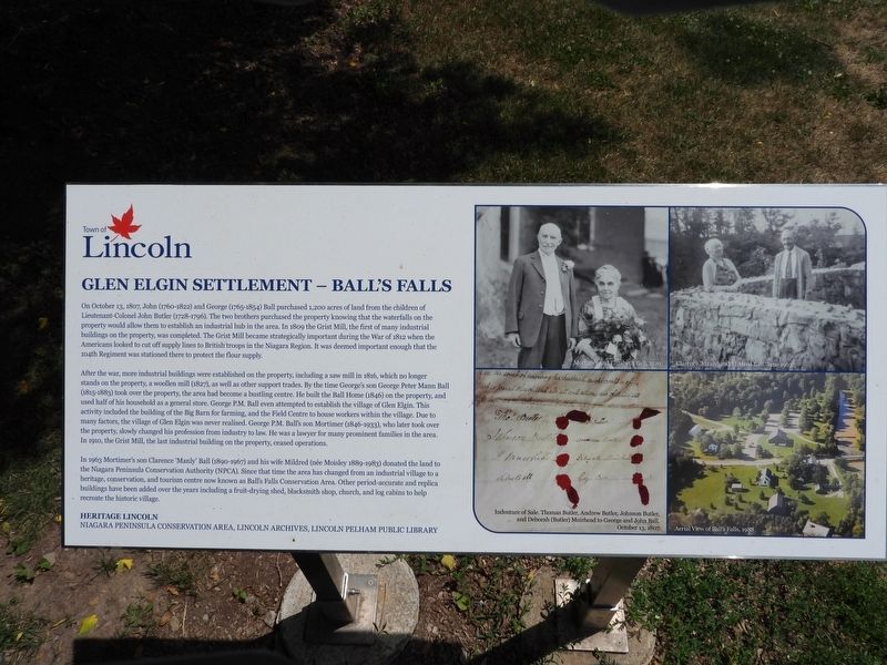
On October 13, 1807, John (1760-1822) and George (1765-1854) Ball purchased 1,200 acres of land from the children of Lieutenant-Colonel John Butler (1728-1796). The two brothers purchased the property knowing that the waterfalls on the property would allow them to establish an industrial hub in the area. In 1809 the Grist Mill, the first of many industrial buildings on the property, was completed. The Grist Mill became strategically important during the War of 1812 when the Americans looked to cut off supply lines to British troops in the Niagara Region. It was deemed important enough that the 104th Regiment was stationed there to protect the flour supply.
After the war, more industrial buildings were established on the property, including a saw mill in 1816, which no longer stands on the property, a woollen mill (1827), as well as other support trades. By the time George's son George Peter Mann Ball (1815-1883) took over the property, the area had become a bustling centre. He built the Ball Home (1846) on the property, and used half of his household as a general store. George P.M. Ball even attempted to establish
this page online
In 1963 Mortimer's son Clarence 'Manly' Ball (1890-1967) and his wife Mildred (née Moisley 1889-1983) donated the land to the Niagara Peninsula Conservation Authority (NPCA). Since that time the area has changed from an industrial village to a heritage, conservation, and tourism centre now known as Ball's Falls Conservation Area. Other period-accurate and replica buildings have been added over the years including a fruit-drying shed, blacksmith shop, church, and log cabins to help recreate the historic village.
Erected by Town of Lincoln.
Topics. This historical marker is listed in these topic lists: Colonial Era • Settlements & Settlers. A significant historical date for this entry is October 13, 1807.
Location. 43° 8.012′ N, 79° 22.963′ W. Marker is in Lincoln, Ontario, in Niagara Region. It is in Ball's Falls. It is on Sixth Avenue, on the right when traveling west. This marker is a few steps from the road, on the right side of a gravel-chip pathway. Touch for map. Marker is at or near this postal address: 3192 Sixth Avenue, Lincoln ON L0R 1S0, Canada. Touch for directions.

Regionally, this marker is on Ontario’s Golden Horseshoe and in Niagara Canada. It is also in Central Canada. Globally, it is in North America, on the Great Lakes, in the Western Hemisphere, in the Western World, and in the Anglosphere. Historically, it finds itself in what was once a British colony, the Viceroyalty of New France, the Haudenosaunee (Iroquois) Confederacy, and Rupert’s Land.
Other nearby markers. At least 8 other markers are within walking distance of this marker: The Ball Home 1846 (here, next to this marker); St. George Anglican Church 1864 (a few steps from this marker); The Village of Glen Elgin (a few steps from this marker); Fairchild Cabin c. 1800s (within shouting distance of this marker); Ball's Grist-Mill (within shouting distance of this marker); The Saw Mill 1816 (about 90 meters away, measured in a direct line); The Blacksmith Shop c. 1850s (about 90 meters away); The Grist Mill 1809 (about 90 meters away). Touch for a list and map of all markers in Lincoln.
Regarding Glen Elgin Settlement - Ball's Falls. 1. The current "Glen Elgin" is a collection of early buildings clustered within Ball's Falls Conservation Area. Some were not from the original Glen Elgin settlement; but were moved here from nearby communities.
2. Here is one map of the buildings: https://npca.ca/images/uploads/trail-maps/Balls_Falls_2023_TRAIL_BROCHURE-colour.pdf
Credits. This page was last revised on August 6, 2025. It was originally submitted on July 12, 2025, by Kevin Westell of St. Catharines, Ontario. This page has been viewed 96 times since then and 23 times this year. Photo 1. submitted on July 12, 2025, by Kevin Westell of St. Catharines, Ontario. • Andrew Ruppenstein was the editor who published this page.
