
Marquette in Marquette County, Michigan — The American Midwest (Great Lakes)
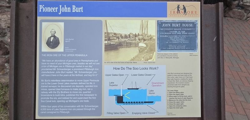
Pioneer John Burt
| — | Iron Ore Heritage Trail | — |
Photographed by Mark Parker, June 25, 2025
1. Pioneer John Burt Marker
The Iron Ore of the Upper Peninsula
"We have an abundance of good ores in Pennsylvania and have no need of your Michigan ores, besides we will not see a ton of Michigan ore in Pittsburgh market in our day", proclaimed Mr. Schoenberger a prominent Pittsburgh iron manufacturer. John Burt replied, "Mr. Schoenberger you will have it here in five years at the farthest, and beg for it."
Mr. Burt's relentless determination to move Upper Peninsula ore to the Lower Great Lakes markets defined his life. A trained surveyor, he discovered ore deposits, operated iron mines, opened blast furnaces to make pig iron, ran a railway with the Ely Brothers to move ore, quarried brownstone to build kilns, published the first newspaper to promote the ore, and lobbied for and supervised the first Soo Canal lock, opening up Michigan's ore trade.
Within four years of his conversation with Mr. Schoenberger 4,000 tons of Lake Superior iron ore passed through the canal consigned to Pittsburgh.
How the Soo Locks Work?
John Burt conceived and designed the system to raise and lower ships at the Soo Locks. Lake Huron is 21 feet lower than
this page online
To Lower Ships
1. Open the valve
2. Open the Upper Gate
3. Allow water to fill the lock, until reaches the level of Lake Superior.
4. Maneuver the ship into the lock.
5. Close the upper valve.
6. Close the upper gate.
7. Open the emptying valve.
8. Open the lower gate.
Drawing: Mike Lempinen
Captions
John Burt at age 47 Photo: Marquette Regional History Center
An 1870 view of the first locks at Sault Ste. Marie. Photo: Superior View
Historic plaque on the exterior of a sandstone structure built by John Burt, in Marquette, Michigan. Photo: Mike Lempinen
Topics. This historical marker is listed in these topic lists: Industry & Commerce • Railroads & Streetcars • Waterways & Vessels. A significant historical year for this entry is 1870.
Location. 46° 31.133′ N, 87° 23.069′ W. Marker is in Marquette, Michigan, in Marquette County. It is at the intersection of South Lake Street and South Front Street (U.S. 41), on the right when traveling

Photographed by Mark Parker, June 25, 2025
2. Pioneer John Burt Marker in front of the Carp River Furnace

Regionally, this marker is on Michigan’s Upper Peninsula. It is also in the American Midwest and on Lake Superior’s South Shore Region. Globally, it is in North America, in the Great North Woods, on the Great Lakes, in the Western Hemisphere, in the Western World, and in the Anglosphere. Historically, it finds itself in what was once the Viceroyalty of New France and also the Northwest Territory.
Other nearby markers. At least 8 other markers are within 2 miles of this marker, measured as the crow flies: Carp River Furnace (here, next to this marker); Migratory Birds of the Great Lakes Region/ Restoring Critical Coastal Habitat to Benefit Birds (approx. 1.4 miles away); A Trail to Adventure (approx. 1½ miles away); Jacques Marquette (approx. 1½ miles away); Lake Superior Art Association (approx. 1½ miles away); Bishop Baraga House (approx. 1.6 miles away); Lower Harbor Ore Dock (approx. 1.6 miles away); Marquette County Courthouse (approx. 1.7 miles

Photographed by Mark Parker, June 25, 2025
3. Pioneer John Burt Marker (left) and Carp River Furnace
Credits. This page was last revised on July 18, 2025. It was originally submitted on July 13, 2025, by Mark Parker of Hickory, North Carolina. This page has been viewed 170 times since then and 42 times this year. Photos: 1, 2, 3. submitted on July 13, 2025, by Mark Parker of Hickory, North Carolina. • J. Makali Bruton was the editor who published this page.
