
Allanburg in Thorold in Niagara Region, Ontario — Central Canada (North America)
Celebrating 200 Years of the Welland Canal
Célébrons 200 ans du Canal Welland
Photographed by Kevin Westell, July 13, 2025
1. Celebrating 200 Years of the Welland Canal - Marker

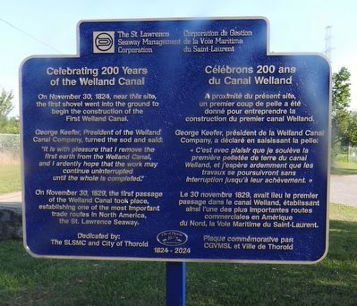
Celebrating 200 Years of the Welland Canal
On November 30, 1824, near this site, the first shovel went into the ground to begin the construction of the First Welland Canal.
George Keefer, President of the Welland Canal Company, turned the sod and said: "It is with pleasure that I remove the first earth from the Welland Canal, and I ardently hope that the work may continue uninterrupted until the whole is completed."
On November 30, 1829, the first passage of the Welland Canal took place, establishing one of the most important trade routes in North America, the St. Lawrence Seaway.
Dedicated by: The SLSMC and City of Thorold
Célébrons 200 ans du Canal Welland
A proximité du présent site, un premier coup de pelle a été donné pour entreprendre la construction du premier canal Welland.
George Keefer, président de la Welland Canal Company, a déclaré en saisissant la pelle: « C'est avec plaisir que je soulève la première pelletée de terre du canal Welland, et j'espère ardemment que les travaux se poursuivront sans interruption jusqu'à leur achèvement. »
Le
this page online
Plaque commémorative par: CGVMSL et Ville de Thorold
1824 - 2024
Erected 2024 by The St. Lawrence Seaway Management Corporation.
Topics and series. This historical marker is listed in these topic lists: Industry & Commerce • Waterways & Vessels. In addition, it is included in the The Welland Canals series list. A significant historical year for this entry is 1824.
Location. 43° 4.585′ N, 79° 12.681′ W. Marker is in Thorold, Ontario, in Niagara Region. It is in Allanburg. It is on Lundy's Lane, on the right when traveling east. This plaque is 20 metres south-west of the Allanburg lift-bridge, and beside a stone cairn. Touch for map. Marker is at or near this postal address: Lundy's Lane, Thorold ON L0S 1A0, Canada. Touch for directions.

Regionally, this marker is on Ontario’s Golden Horseshoe and in Niagara Canada. It is also in Central Canada. Globally, it is in North America, on the Great Lakes,
Photographed by Kevin Westell, July 13, 2025
2. Celebrating 200 Years of the Welland Canal - Marker in context
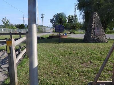
Photo looks south from Lundy's Lane (Hwy 20), just west of the Allanburg Bridge.
Other nearby markers. At least 8 other markers are within 5 kilometers of this marker, measured as the crow flies: The Old Welland Canal (here, next to this marker); Allanburg United Church 1876 (approx. 0.3 kilometers away); Allanburg Village Cemetery c.1813 (approx. 0.4 kilometers away); The Beaverdams Church 1832 (approx. 3.3 kilometers away); Bouk Family Homestead 1855 (approx. 3.4 kilometers away); Old Beaverdams Burying Ground (Smith Cemetery) 1801 (approx. 3.4 kilometers away); Robert Ross House (approx. 3.9 kilometers away); Camp House (approx. 4 kilometers away). Touch for a list and map of all markers in Thorold.
Another marker is no longer nearby. Griffiths House c. 1922 (was approx. 3.5 kilometers away but has been confirmed missing).
Photographed by Kevin Westell, July 13, 2025
3. Celebrating 200 Years of the Welland Canal - Marker in context
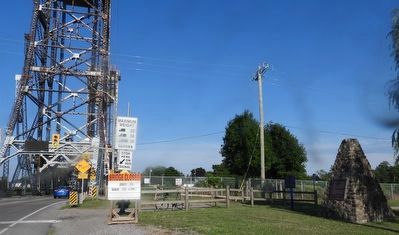
Photo faces east along Lundy's Lane (Hwy 20). The marker is on the right, just left of the stone cairn. The vertical lift bridge carries Lundy's Lane over the Welland Canal.
Credits. This page was last revised on July 16, 2025. It was originally submitted on July 13, 2025, by Kevin Westell of St. Catharines, Ontario. This page has been viewed 85 times since then and 19 times this year. Photos: 1. submitted on July 13, 2025, by Kevin Westell of St. Catharines, Ontario. 2, 3. submitted on July 14, 2025, by Kevin Westell of St. Catharines, Ontario. • Andrew Ruppenstein was the editor who published this page.
