Kure Beach in New Hanover County, North Carolina — The American South (South Atlantic)
"How Grand a Fame It Watches Over": The Fort Fisher Monument
Photographed by Evan Dwyer, January 24, 2025
1. "How Grand a Fame It Watches Over": The Fort Fisher Monument Marker
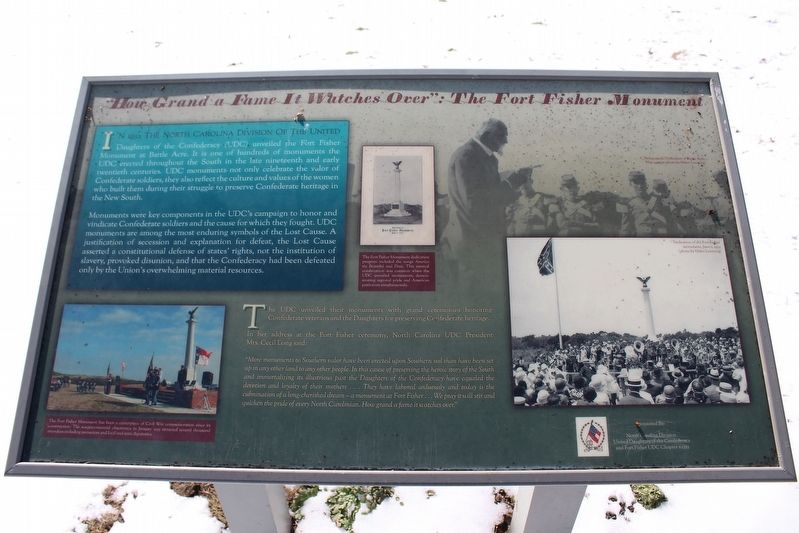
Monuments were key components in the UDC's campaign to honor and vindicate Confederate soldiers and the cause for which they fought. UDC monuments are among the most enduring symbols of the Lost Cause. A justification of secession and explanation for defeat, the Lost Cause asserted a constitutional defense of states' rights, not the institution of slavery, provoked disunion, and that the Confederacy had been defeated only by the Union's overwhelming material resources.
The UDC unveiled their monuments with grand ceremonies honoring Confederate veterans and the Daughters for preserving Confederate heritage.
In her address at the Fort Fisher ceremony,
this page online
"More monuments to Southern valor have been erected upon Southern soil than have been set up in any other land to any other people. In this cause of preserving the heroic story of the South and immortalizing its illustrious past the Daughters of the Confederacy have equaled the devotion and loyalty of their mothers... They have labored arduously and today is the culmination of a long-cherished dream - a monument at Fort Fisher... We pray it will stir and quicken the pride of every North Carolinian. How grand a fame it watches over."
Sponsored By:
North Carolina Division United Daughters of the Confederacy and Fort Fisher UDC Chapter #2325
(captions)
Background: Dedication of Battle Acre, May 24, 1931 (photo by Helen Lovering)
The Fort Fisher Monument has been a centerpiece of Civil War commemoration since its construction. The sesquicentennial observance in January 2015 attracted several thousand attendees including reenactors and local and state dignitaries.
The Fort Fisher Monument dedication program included the songs America the Beautiful and Dixie. This musical combination was common when the UDC unveiled monuments, demonstrating regional pride and American patriotism simultaneously.
Dedication of the Fort Fisher monument, June 2, 1932 (photo by Helen Lovering)"
Erected 2017

Photographed by Evan Dwyer, January 24, 2025
2. The 1932 Fort Fisher Monument
Marker is at left.
Topics. This historical marker and monument is listed in this topic list: War, US Civil. A significant historical date for this entry is June 2, 1932.
Location. 33° 58.158′ N, 77° 55.092′ W. Marker is in Kure Beach, North Carolina, in New Hanover County. It is at the intersection of Battle Acre Road and Fort Fisher Boulevard South (U.S. 421), on the right when traveling south on Battle Acre Road. Marker is at the Battle Acre driving tour stop across southeast of the Fort Fisher Historic Site Visitor Center. Touch for map. Marker is at or near this postal address: 1610 Fort Fisher Blvd S, Kure Beach NC 28449, United States of America. Touch for directions.

Regionally, this marker and monument is in the Coastal Plain and on the Cape Fear Coast. It is also in the American South, specifically in the Upper South, in the Tidewater, and on the Eastern Seaboard. Globally, it is in the North Atlantic Region, North America, the Western Hemisphere, the Western World, and the Anglosphere. Historically, it finds itself in what was once the territory of the Mississippian Culture, one of the original Thirteen Colonies, one of the Confederate States of America, and the Antebellum South.
Other nearby markers. At least 8 other markers are within walking distance of this marker: Fort Fisher Monument (a few steps from this marker); …A Light House And Dwelling House At Federal Point (a few steps from this marker); Headquarters of Fort Fisher (a few steps from this marker); Fort Fisher (within shouting distance of this marker); W.H.C. Whiting (about 300 feet away, measured in a direct line); The Columbiad Battery (about 400 feet away); a different marker also named Fort Fisher (about 500 feet away); Our Occupation Of The Fort, Was Not Equivalent To Its Possession. (about 600 feet away). Touch for a list and map of all markers in Kure Beach.
Other markers no longer nearby. Fighting the Sea - Saving the Fort (was about 600 feet away but has been confirmed missing); Blockade-Running (was about 600 feet away but has been confirmed missing); Fort Fisher Since 1865 (was about 600 feet away but has been replaced with another marker now near it).
Additional commentary.
1. 2015 Series of Markers
The following markers were placed at Fort Fisher State Historic Site on the site walking trail as part of the 150th Anniversary of the battles in 2015:
278788
278793
278799
278843
278848
278856
278903
278907
278909
278913
278919
278923
278926
278936
This marker (278761) is in the same style but was placed at the Fort Fisher monument at Battle Acre in 2017. Three other markers outside of the site history trail (278940, 278774, and 278764) are all the same styling and may also be part of the 2015 re-signing effort.
— Submitted July 17, 2025, by Evan Dwyer of Richmond, Virginia.
Credits. This page was last revised on July 27, 2025. It was originally submitted on July 15, 2025, by Evan Dwyer of Richmond, Virginia. This page has been viewed 216 times since then and 30 times this year. Photos: 1, 2. submitted on July 15, 2025, by Evan Dwyer of Richmond, Virginia. • Bernard Fisher was the editor who published this page.
