Kure Beach in New Hanover County, North Carolina — The American South (South Atlantic)
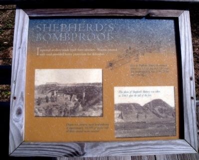
Shepherd’s Bombproof
Photographed by Bernard Fisher, March 11, 2010
1. Shepherd’s Bombproof Marker
Improved artillery made brick forts obsolete. Rooms covered with sand provided better protection for defenders.
(captions)
Here at Shepherd’s Battery the entrance tunnel was 63 feet long and 3 feet wide. The bombproof itself was 15 by 18 feet and 5 feet high.
Despite two immense naval bombardments of approximately 20,000 projectiles each, all thirty covered rooms survived.
This photo of Shepherd’s Battery was taken in 1865 after the fall of the fort.
Erected by Fort Fisher State Historic Site. (Marker Number 9.)
Topics. This historical marker is listed in these topic lists: Forts and Castles • War, US Civil.
Location. Marker has been reported missing. It was located near 33° 58.321′ N, 77° 55.199′ W. Marker was in Kure Beach, North Carolina, in New Hanover County. It could be reached from Fort Fisher Boulevard South (U.S. 421) near Battle Acre Road. This marker is located along the quarter-mile tour trail at Fort Fisher State Historic Site. Touch for map. Marker was at or near this postal address: 1610 Fort Fisher Boulevard South,
this page online

Regionally, this marker was in the Coastal Plain and on the Cape Fear Coast. It was also in the American South, specifically in the Upper South, in the Tidewater, and on the Eastern Seaboard. Globally, it was in the North Atlantic Region, North America, the Western Hemisphere, the Western World, and the Anglosphere. Historically, it found itself in what was once the territory of the Mississippian Culture, one of the original Thirteen Colonies, one of the Confederate States of America, and the Antebellum South.
Other nearby markers. At least 8 other markers are within walking distance of this location: War Never Witnessed More Determined Bravery. (a few steps from this marker); Not Fortifications, But Fiftyfications At Least (within shouting distance of this marker); Shepherd's Battery #1 (within shouting distance of this marker); The One Weak Point In The 'Malakoff' Was The Gate (within shouting distance of this marker); Every Charge Was Death Or Surrender. (within shouting distance of this marker); A Work Of More Labor Than The Pyramids (about 300
Photographed by Bernard Fisher, March 11, 2010
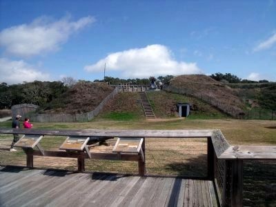
2. View of Shepherd’s Bombproof.
Other markers no longer nearby. Shepherd’s Battery (was here, next to this marker but has been confirmed missing); Restoration of Shepherd’s Battery (was here, next to this marker but has been confirmed missing); a different marker also named Shepherd’s Battery (was within shouting distance of this marker but has been confirmed missing); River Road Sally Port (was within shouting distance of this marker but has been replaced with another marker now near it); Union Fiasco - The First Battle (was about 300 feet away, measured in a direct line but has been replaced with another marker now near it).
Also see . . . Fort Fisher. North Carolina Historic Sites (Submitted on March 15, 2010, by Bernard Fisher of Richmond, Virginia.)
Photographed by Bernard Fisher, March 11, 2010
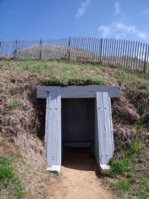
3. Shepherd’s Bombproof
Photographed by Timothy H. O'Sullivan, Jan 1865
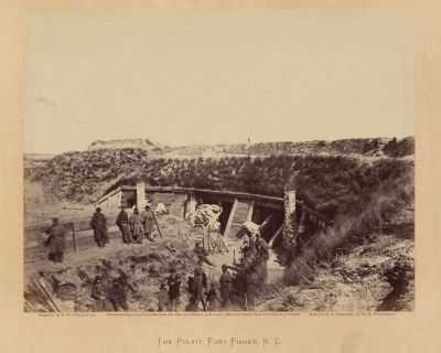
4. The pulpit, Fort Fisher, N.C.
Positive by Alexander Gardner. Library of Congress [LC-DIG-ppmsca-12600]
Credits. This page was last revised on July 17, 2025. It was originally submitted on March 15, 2010, by Bernard Fisher of Richmond, Virginia. This page has been viewed 994 times since then and 26 times this year. Last updated on July 16, 2025, by Evan Dwyer of Richmond, Virginia. Photos: 1, 2, 3. submitted on March 15, 2010, by Bernard Fisher of Richmond, Virginia. 4. submitted on March 16, 2010, by Bernard Fisher of Richmond, Virginia.
