Marker Logo
THE HISTORICAL
MARKER DATABASE
“Bite-Size Bits of Local, National, and Global History”
Fort Erie in Niagara Region, Ontario — Central Canada (North America)
 

Bertie Hall
 
 
Bertie Hall - Marker image. Click for full size.
Photographed by Kevin Westell, July 18, 2025
1. Bertie Hall - Marker
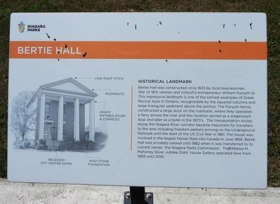
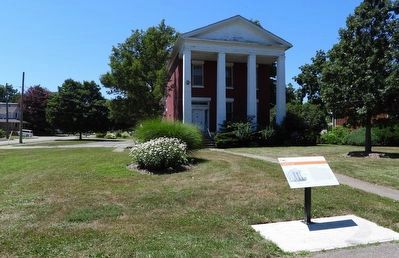
Inscription. Bertie Hall was constructed circa 1833 by local businessman, War of 1812 veteran and colourful entrepreneur William Forsyth Sr. This impressive landmark is one of the earliest examples of Greek Revival style in Ontario, recognizable by the squared columns and large triangular pediment above the portico. The Forsyth family constructed a large dock on the riverbank, where they operated a ferry across the river and this location served as a stagecoach stop and later as a hotel in the 1870's. The transportation routes along the Niagara River corridor became important for travellers to the area including freedom seekers arriving on the Underground Railroad until the start of the US Civil War in 1861. The house was involved in the largest Fenian Raid into Canada in June 1866. Bertie Hall was privately owned until 1982 when it was transferred to its current owner, The Niagara Parks Commission. The Mildred M. Mahoney Silver Jubilee Dolls' House Gallery operated here from 1983 until 2010.
 
Erected by Niagara Parks.
 
Topics. This historical marker is listed in these topic lists: ArchitectureNotable Buildings
Paid Advertisement
Click or scan to see
this page online
Waterways & Vessels. A significant historical year for this entry is 1833.
 
Location. 42° 55.911′ N, 78° 54.898′ W. Marker is in Fort Erie, Ontario, in Niagara Region. It is on Niagara Boulevard, on the right when traveling south. Touch for map. Marker is at or near this postal address: 657 Niagara Boulevard, Fort Erie ON L2A 3H9, Canada. Touch for directions.

Regionally, this marker is on Ontario’s Golden Horseshoe and in Niagara Canada. It is also in Central Canada. Globally, it is in North America, the Western Hemisphere, the Western World, and the Anglosphere. Historically, it finds itself in what was once a British colony, the Viceroyalty of New France, the Haudenosaunee (Iroquois) Confederacy, and Rupert’s Land.

Other nearby markers. At least 8 other markers are within walking distance of this marker: 202 Dufferin Street (approx. 0.4 kilometers away); 1873 - 1973 International Railway Bridge (approx. 0.4 kilometers away); Sir Casimir Gzowski (approx. 0.4 kilometers away); The Mentholatum Company of Canada, Ltd. (approx. half a kilometer away); Niagara River and her Ships (approx. 0.7 kilometers away in
Bertie Hall image. Click for full size.
Photographed by Kevin Westell, July 18, 2025
2. Bertie Hall
the U.S.); Black Rock Lock (approx. 0.7 kilometers away in the U.S.); Thunder Over the Niagara (approx. 0.8 kilometers away in the U.S.); The Fenian Invasion of 1866 (approx. one kilometer away in the U.S.). Touch for a list and map of all markers in Fort Erie.
 
 
Credits. This page was last revised on July 21, 2025. It was originally submitted on July 19, 2025, by Kevin Westell of St. Catharines, Ontario. This page has been viewed 161 times since then and 55 times this year. Photos:   1, 2. submitted on July 19, 2025, by Kevin Westell of St. Catharines, Ontario. • Andrew Ruppenstein was the editor who published this page.

m=279096

CeraNet Cloud Computing sponsors the Historical Marker Database.
This website earns income from purchases you make after using our links to Amazon.com. We appreciate your support.
Paid Advertisement
Jul. 8, 2026