
Welland in Niagara Region, Ontario — Central Canada (North America)
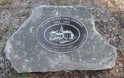
Welland Canal Second Aqueduct
1842 - 1850
Photographed by Kevin Westell, July 21, 2025
1. Welland Canal Second Aqueduct Marker
1842 - 1850
Designated 2022
City of Welland Heritage Advisory Committee
Erected 2022 by City of Welland Heritage Advisory Committee.
Topics and series. This historical marker is listed in this topic list: Waterways & Vessels. In addition, it is included in the The Welland Canals series list. A significant historical year for this entry is 1842.
Location. 42° 59.6′ N, 79° 14.963′ W. Marker is in Welland, Ontario, in Niagara Region. It is at the intersection of Cross Street and The Boardwalk, on the right when traveling south on Cross Street. Touch for map. Marker is in this post office area: Welland ON L3B 3E9, Canada. Touch for directions.

Regionally, this marker is on Ontario’s Golden Horseshoe and in Niagara Canada. It is also in Central Canada. Globally, it is in North America, on the Great Lakes, in the Western Hemisphere, in the Western World, and in the Anglosphere. Historically, it finds itself in what was once a British colony, the Viceroyalty of New France, the Haudenosaunee (Iroquois) Confederacy, and Rupert’s Land.
Other nearby markers. At least
this page online
Regarding Welland Canal Second Aqueduct. The aqueduct was a "bridge" for the Welland canal over the Welland River. (The path for the river to go underneath was called a "syphon culvert".) This was required because the canal was at a higher water level than the river. From overhead, it is shaped similar to a lock.
Ships travelled over this 2nd canal aqueduct from c.1845 - c.1883, when the 3rd Welland canal started carrying traffic. The waterway
Photographed by Kevin Westell, July 21, 2025
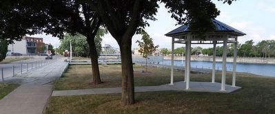
2. Welland Canal Second Aqueduct Marker
The marker is next to the sapling, beyond the gazebo.
Also see . . . Welland Canal (Wikipedia). (Submitted on August 23, 2025, by Michael Herrick of Southbury, Connecticut.)

Photographed by Kevin Westell, July 21, 2025
3. Welland Canal Second Aqueduct
Photo faces north-east, along the length of the former aqueduct. (The marker and gazebo are distantly visible.) A boardwalk leads across the aqueduct to a viewing platform. In the distant left, the wall of the 4th canal's aqueduct is left of the recreational canal.
Photographed by Kevin Westell, August 1, 2025
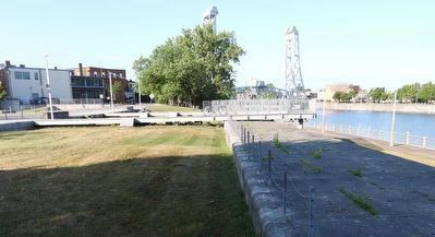
4. Welland Canal Second Aqueduct
Photo faces south-west. The boardwalk crosses and extends beyond the aqueduct's wall. Welland's recreational canal is on the right; Bridge 13 (the Main Street bridge) is in the background.

Photographed by Kevin Westell, July 21, 2025
5. Fourth Welland Canal Aqueduct
Photo faces north. This is the east side of the aqueduct, and the downstream side of the Welland River. Water level varies seasonally; highest in early spring.
Credits. This page was last revised on August 23, 2025. It was originally submitted on July 22, 2025, by Kevin Westell of St. Catharines, Ontario. This page has been viewed 92 times since then and 12 times this year. Photos: 1, 2, 3. submitted on July 22, 2025, by Kevin Westell of St. Catharines, Ontario. 4. submitted on August 2, 2025, by Kevin Westell of St. Catharines, Ontario. 5. submitted on July 22, 2025, by Kevin Westell of St. Catharines, Ontario. • Michael Herrick was the editor who published this page.
