
Crowland in Welland in Niagara Region, Ontario — Central Canada (North America)
Crowland Centennial Project
Centennial of Confederation

Photographed by Kevin Westell, July 21, 2025
1. Crowland Centennial Project Marker
Erected by the Township of Crowland in permanent commemoration of the Centennial of Confederation in Canada in 1967.
Construction was made possible through the co-operation of the Province of Ontario and the Government of Canada.
Erected 1967.
Topics. This historical marker is listed in these topic lists: Parks & Recreational Areas • Patriots & Patriotism. A significant historical year for this entry is 1867.
Location. 42° 59.615′ N, 79° 11.372′ W. Marker is in Welland, Ontario, in Niagara Region. It is in Crowland. It is on Lyons Creek Road east of Darby Road, on the left when traveling east. Touch for map. Marker is at or near this postal address: 595 Lyons Creek Rd, Welland ON L3B 5N4, Canada. Touch for directions.

Regionally, this marker is on Ontario’s Golden Horseshoe and in Niagara Canada. It is also in Central Canada. Globally, it is in North America, the Western Hemisphere, the Western World, and the Anglosphere. Historically, it finds itself in what was once a British colony, the Viceroyalty of New France, the Haudenosaunee (Iroquois) Confederacy, and Rupert’s Land.
Other nearby markers. At
this page online
Regarding Crowland Centennial Project. Named after a town in Great Britain, the Township of Crowland spent its centennial money beautifying Cook's Mill park, which currently sports a playground, baseball diamond, cricket pitch and plenty of flat green grass for seasonal festive events.

Photographed by Kevin Westell, July 21, 2025
2. Crowland Centennial Project Marker
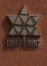
Photographed by Kevin Westell, July 21, 2025
3. The Canada Centennial Logo
Credits. This page was last revised on August 23, 2025. It was originally submitted on July 23, 2025, by Kevin Westell of St. Catharines, Ontario. This page has been viewed 61 times since then and 12 times this year. Photos: 1, 2, 3. submitted on July 23, 2025, by Kevin Westell of St. Catharines, Ontario. • Michael Herrick was the editor who published this page.
